You need a hankie to clean your desk now? ![]()
7 Likes
ROFLMAO- no I kept all inside my pants
5 Likes
HERE:
We are proud to share some work in progress on the A-6E’s radar and Terrain Clearance mode.
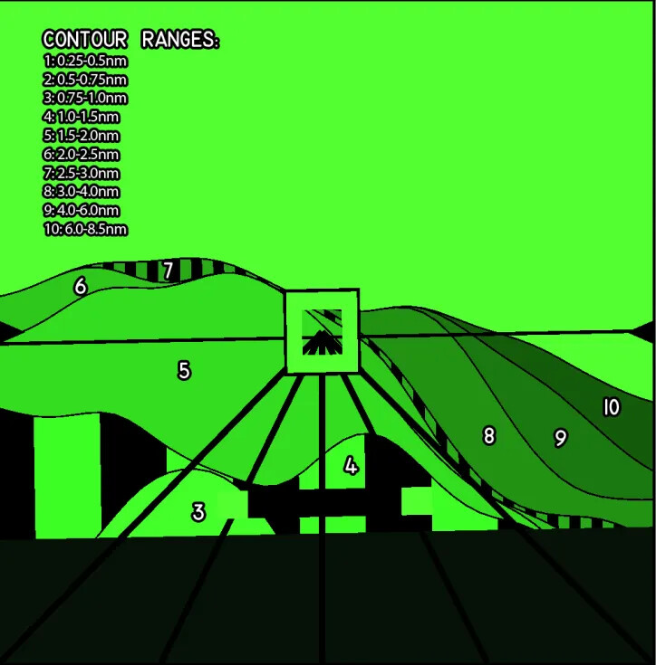
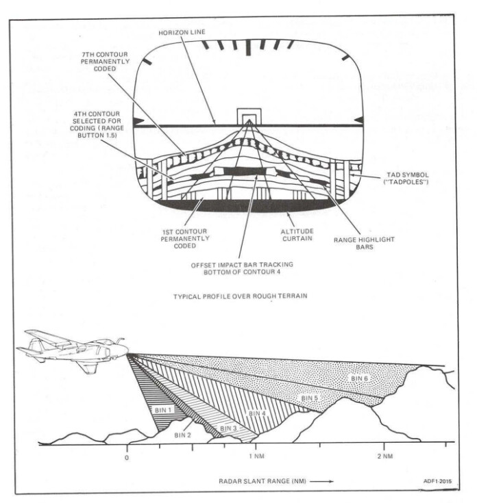
Since we are not blessed with the eyes of chameleons, we’ve pulled the Bombardier/Navigator’s Radar Display and the Pilot’s Analog Display Indicator (ADI) into debug windows that allow us to see both side by side, as well as the terrain outside the cockpit for comparison. Please note that the cockpit model is a placeholder and not representative of the final product. In this example, the radar is in Terrain Clearance (TC) mode, which restricts the display to ~8.5nm and the minimum scan angle to ~60°. In this mode, the radar’s primary purpose is to drive the display on the ADI. During normal flight, the Pilot’s ADI is almost identical to the similar display in the F-14 Tomcat, the VDI, however when TC mode is selected, it displays a 53° (horizontal) x 26° (vertical) pictorial representation of the terrain ahead of the aircraft based on the data supplied by the radar. On the ADI we see the black Horizon Line and Fiducial Markers that help mark our pitch and bank attitude. In the center are the Steering Symbol and Flight Path Lines, currently locked to the aircraft heading. Behind this symbology are displayed ten discreet bands, each representing a range contour, from ~0.25nm out to 8.5nm. Bands 1 and 7 are permanently coded with range coding bars for identification, while bands 3-6 may be selected for coding - that is to display the vertical black bars - based on Pilot input. In the example below, band 4 is selected for coding by the Pilot. The Pilot maintains clearance over the terrain by flying the aircraft so that the Offset Impact Bar (black and green, fixed near bottom of screen) is situated above one of the coded bands 3-6 - the selected band determines the clearance height and smoothness of the ride. Finally, at the bottom of the screen is the dark green Altitude Curtain. This moves up and down the screen relative to the Horizon Line to represent the radar altitude. Its range is not linear and does not correspond to the terrain contour bands, but serves as a visual guide to aide piloting. More symbology remains to be added but we hope this demonstration gives some insight into our progress on a rather unique feature of the DCS A-6E Intruder.
Your Heatblur Team
EDIT: Sorry for the embed fail
14 Likes
No worries, I got the ping this afternoon. Just FYI, discord links will stop working after a short time. You might want to share it via another platform if possible.
4 Likes
That’s awesome.
Here it is, freed from the whims of an unstable CDN URL, from a 55MB GIF bloat that stutters on my phone, rendered in all its beauty as a smooth 1.4MB WEBM, on catbox.moe, hosted by a friendly, generous stranger:
![]()
9 Likes