Well, at least that Fokker isn’t flying a Messerschmitt!
Sorry, someone had to. ![]()
Looooove it…soooo many steam gauges. ![]()
Well, at least that Fokker isn’t flying a Messerschmitt!
Sorry, someone had to. ![]()
Looooove it…soooo many steam gauges. ![]()
Nice job getting the first leg done. Nice AAR.
Nice AAR @TheAlmightySnark . I have to admit I saw it on sale and I am tempted to pick it up.
You could also wait for the 70/100 if you enjoy a more modern flightdeck, much like the BAE-146/Avro series.
That’s the Fenix A320, it’s a superb addon.
Part 11 - Is that a Rocket in your Pocket, or…
I was starting to feel bad about potentially putting Paul’s Bad Influencer tag in jeopardy and was about to add the Hot Start TBM 900 to my hangar (even though it has very similar performance, range and even looks a bit like the Epic E1000), when this caught my eye:
I present to you, TorqueSim’s Pocket Rocket
OK, this isn’t a real aircraft. But I’m not a real pilot, so I guess it evens out?
But with the following specs, it will give me a bit more choice for some of those longer legs:
Engine: PT6A-28
Takeoff Distance: < 500 ft
Landing Distance: < 300 ft
Fuel Capacity: 1155 lbs
Range @ High-Speed Cruise (Mach 0.595 / FL 250): 1310 NM
Range @ Economy Cruise (Mach 0.570 / FL 250): 1580 NM
Service Ceiling: FL250
And, it is rated for aerobatics.
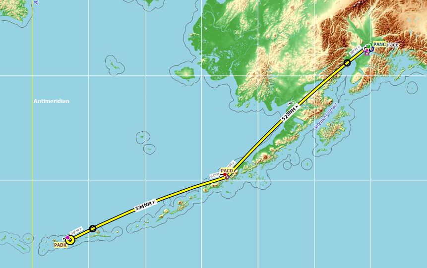
PADK to PANC (with PACD as an ALT/WPT)
And the Pocket Rocket takes off like… a rocket!
It is fun to fly. Did I mention that it is rated for aerobatics ![]()
Once again, I have a nice chain of islands to follow VFR, but this time I’m letting the AP do most of the work. At my age toilet breaks are more important.
Passing my waypoint at PACD
The best thing about X-Plane 11 is that while I don’t get the eye candy of MSFS, I get a great VR experience.
In synthetic vision we trust. Without the flightpath marker, if I was relying on the Mk.1 Eyeball I would have sworn I was going to run into that peak!
I think next time I fly this I will use the tricycle/retractable gear version… I’m still getting to grips with landing a tail dragger and used most of the runway.
Parked at the the exec ramp. Now to decide where to head next?
Edit: I have just discovered that this Pocket Rocket is based on a real aircraft ![]() albeit with an Allison turbine, not a PT6:
albeit with an Allison turbine, not a PT6:

However, TorqueSim may have taken a bit of ‘poetic licence’ with it, especially the ceiling and range, and I am still not a real pilot ![]()
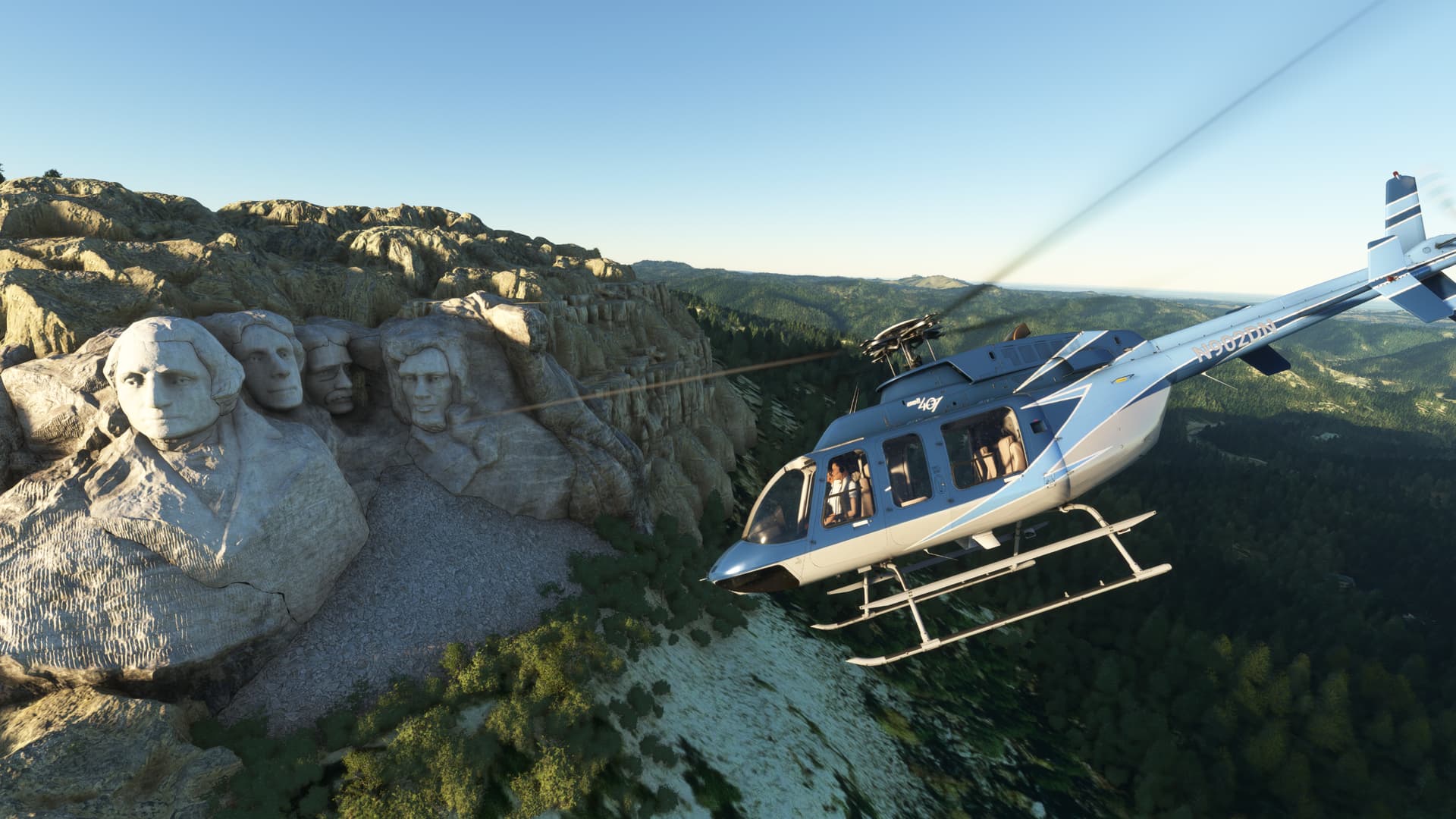
Being in Rapid City, I had to check out the local sights!
After the joyriding was done, it was time to fire up the newly released iFly 737 MAX8. For this leg, I’d fly from Rapid City to Chicago Midway Airport.
Probably the easiest recce feature, the serrated chevrons are unique to the MAX versions of the 737.
Hey, look! A 737 in FS2020 actually capable of RNP AR type approaches!
Looking at you, PMDG.
Taxiing to the gate at MDW. I bought this scenery some time ago on sale through ORBX, unfortunately I just haven’t used it that much. Shame, it’s really quite nice.
LEG 9: Halim Perdanakusuma International Airport Jakarta, Indonesia (WIHH) TO Christmas Island International Airport, Christmas Island, Australia (YPXM).
Leg number next is a brief sea voyage of some 261NM from Jakarta to Christmas Island because, how could it not be? The chance to see Santa’s summer home is just the kind of pointless and stupid gesture that I’m known for…to the extent that I’m known for anything.
Don’t look that up! ![]()
Today in my shiny new Cirrus SR22. I tend to steer away from “new GA” in favor of something with vibrating (and usually bent) needles that looks like it has been over the Somme at least twice.
But I have to say that the Cirrus surprised me as being an honest and capable flier.
Challenge number first, what is it that only has 9% power and why is there only 9% of it?
After an exhaustive search of the electrical system, I accidentally bumped the throttle…throttle setting. It’s the throttle setting. ![]()
![]()
I’m sure that there is a very good reason that the Cirrus has both the traditional engine instruments and a power setting gauge, but I’m just going to leave that one up to the curious.
This is quite a setup!
Alright, enough of my master class in Avionics Design…
After a dramatic, sweeping turn mostly brought on by not syncing my heading to that of the runway…
I deviate from my course somewhat to see the sights of downtown Jakarta. I could pretend that I know what all those things down there are, but mostly I had to turn on the POI setting to identify them.
Here you can just make out the Ciliwung River right next to the blue topped Wisma 46 building.
Boy, I’m really selling it…maybe I should have been a tour guide. ![]()
Alright, enough pretending that I know what I’m talking about…
Now I need to pretend that I know how to fly! Fortunately, the morning contains no more weather than is strictly necessary for dramatic effect.
Once I pass over the central spine of the island, here between Mt. Salak and Mt. Gede, it was all downhill from there, literally.
And I come to the last land of the Greater Sunda Islands near Ujunggenteng in short order.
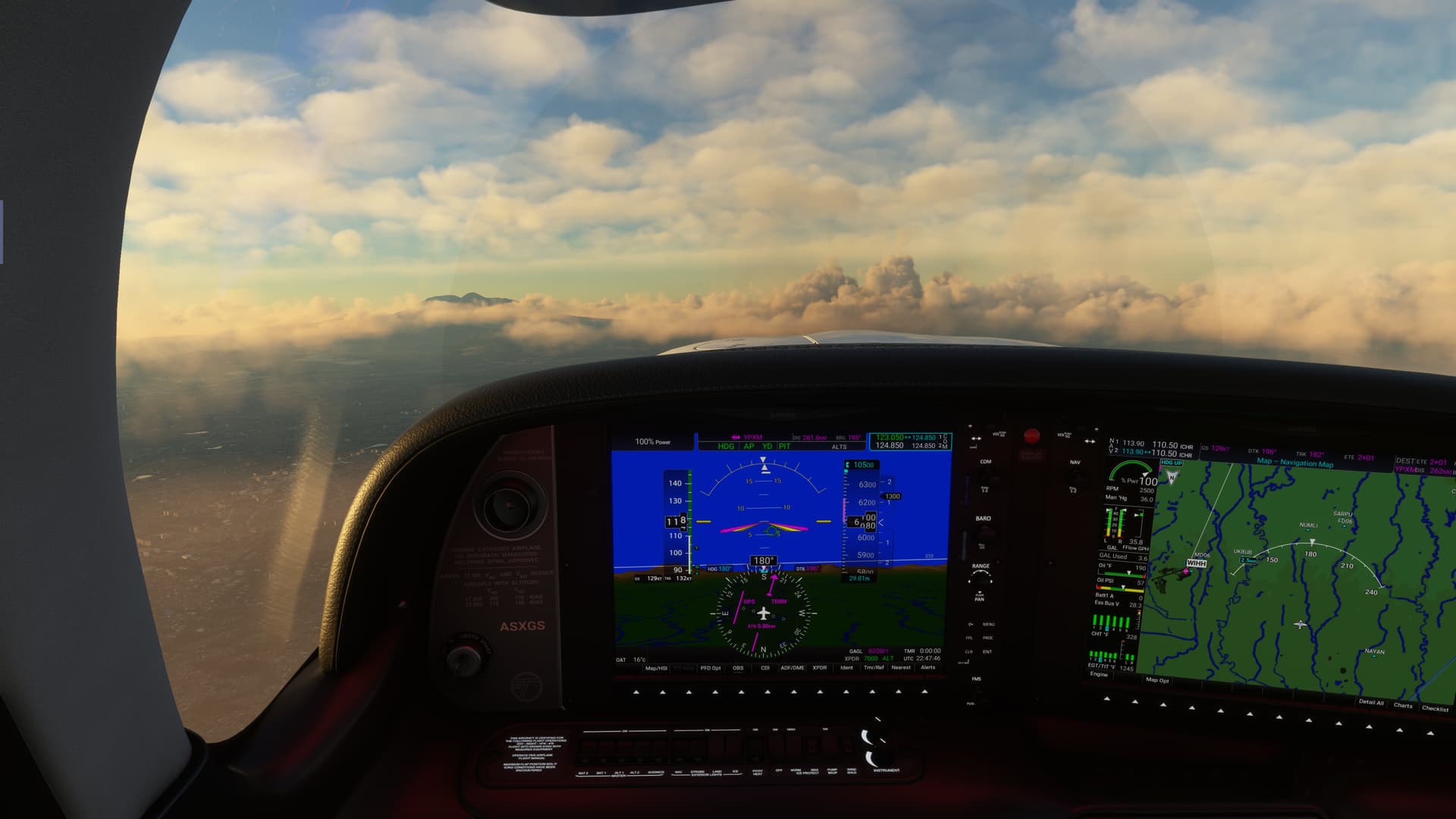
I manage to get the RNAV loaded, but still don’t have much luck with the VNAV. I always seem to be able to get the VNAV to stick eventually, but it never feels like it’s taking the handoff as soon as it should. Clearly, I’m missing a step (providing it works as advertised).
No worries, I just bring her down the old-fashioned way. There’s only one cloud deck from the sea to the stars.
And it happens to sit right at the IAF altitude. ![]()
Once I start down, however, the island comes into view.
I’m a little disappointed. There’s not a Snow Castle or Candy Cane in sight!

There was a little weirdness on final. While hand flying on glideslope, I picked up a very pronounced sink rate that took almost full power to overcome. This leads to a big balloon and a long landing as I bleed off the extra speed.
It felt like a big thermal, but overexaggerated. Kind of insta-microburst on an otherwise calm day.
I was at full flaps at the time, and I have a feeling that maybe this aircraft has a bit of an overrepresented amount of drag. This will be a thing on the next leg as well. ![]()
In any event, I made it in, none the worse for wear. ![]()
LEG 10: Christmas Island International Airport, Christmas Island, Australia (YPXM) TO Learmonth Airport, Exmouth, Australia (YPLM).
Time for the first of my series of long(er) overwater flights, Christmas Island to Learmonth on Australia proper.
Since there was no sense of going over water slowly, I picked the fastest of the choices available to me, the Citation Longitude.
The more observant of you will also notice that it is night. Again, light featureless water vs dark featureless water.

And look, a new avionics set…
Yay.

Ten different airplanes, and I still can’t find the &%$* cup holder! ![]()
Without much ceremony, I put the power in the corner and said goodbye to the worst Santa’s village I have ever visited! ![]()
I so infrequently get the chance to go up to FL450 (Hell, the 321 is lucky to reach 350!) that I couldn’t pass up the opportunity.
So I put her on the roof, which had the virtue of driving the Sun up.
Dawn on Demand!
The view outside was stupendous. The pictures just don’t do it justice. The entire compressed spectrum giving way to deep black night with the Milky Way sprayed across the heavens!
In remarkably short order, the bowl of night flipped, with dawn overtaking the last slice of true night. My aircraft was already in the Sun.
And finally, Sunrise!
Again, nice touch by Asobo, the shadows are stark, almost space like, up here in what I can only hear pronounced in a West Virginia accent as, “The thin air”.
And made a little smoky in the, presumably polarized, windows of the Longitude.
Well, Sun is up, coffee brewing, time to get to work.
All kidding aside, the separate touchscreens of the Longitude seem a bit more intuitive than some of the others…even though there are more screens in here than I sometimes know what to do with.
More importantly, by skill or accident, the VNAV works like a champ and right off the bat.
I don’t feel as though I did anything differently, but who knows?
With everything working as it should, the aircraft descends beautifully.
One thing, and I alluded to it before, the drag model on some of these aircraft feels a little off. Here I have a target VSI of about 2500FPM for a 3 degree glidepath at my programmed speed.
But the throttle settings required to maintain my, admittedly fast, selected speed (0.82M/320KIAS) feel quite high, like I’m flying with the speedbrake out (I wasn’t…I checked ![]() ).
).
Honestly, I can’t tell if this is just how it is and I never notice in real aircraft, or if there is something a bit off with the thrust/drag models in some of the default planes. ![]()
In any event, I soon cross the barren coast of the continent. I get very Baja California vibes here.
A quick turn onto final…
And I’m on RNAV final, all coupled up, on and on.
Nice when it all works, huh?
A quick dip over the bay and I’m crossing the numbers.
And here we are. Time for a cold Victoria Bitter…mmmmmm, I can still taste it!
Probably should get a Swan Lager, you will likely get lynched in WA for ordering a VB… Besides they all come from the same brewery and taste pretty much the same ![]()
I keep telling the kids these days ‘play often with your mobiles/tablets and you become pilots one day’ ![]()
Ha! Didn’t know that. We stopped in Perth and Sydney and I seem to recall drinking a lot of VB…but I can’t remember where. ![]()
I was Shore Patrol in Sydney, so I was inconsolably sober there which made me think it was Perth.
What and wherever it was, they sure went down smooth! ![]()
Well it wasn’t VB then ![]()
(For the non-Australians: as a person from Queensland I risk losing my citizenship if I don’t claim that XXXX is superior to all other Australian beer… and I actually grew up less than 20km from where it is brewed - but that’s another story…)
The six weeks at sea may have had something to do with that. ![]()
![]()
Here’s my placeholder. I started from Pensacola and got as far as BGBW, but the forecast for BIRK was lousy (400 foot ceilings and freezing rain) so I buttoned the aircraft down to wait for better weather.
OK, I finally managed to get started. I was planning on starting yesterday but when I saw the weather forecast I thought I’d give it a miss. I haven’t opened a flight sim in over a year and jumping straight back into heavy IMC and 40 knot winds in my little 172 was probably bighting off more than I can chew!
This year I am determined to get to grips with MSFS properly, and this challenge is a chance for me to brush up on my pilotage skills. So, rather than my usual approach of starting up the sim, getting straight into the air, pointing myself roughly in the right direction and then figuring it all out as I go, I am going to plan (and hopefully execute) this trip as if it were real life! No using the VFR map to get myself out of trouble, no using slew to correct my position, no ignoring airspace restrictions or flight rules. This is going to be fun and a learning experience. ![]()
I figure every good plan starts with … well, a plan. So I make one:
The first obstacle is Stansted Airport. I’m leaving from North Weald as this is the most convenient GA airfield for me to get to. However, it sits just south of of the Stansted Class D so I have a choice. If I go around to the west there is a corridor between Stansted and Luton but it’s maybe a bit narrow? Plus there are a plethora of small aerodromes further north to dodge. It seems simpler to go east to the CLN VOR then turn north, so that’s what I plan. I have to keep below 2,500’ until out from under the London ATZ which stretches all the way from FL 25 to FL 195.
Heading north from CLN I plan to overfly Wattisham Airfield at 4000’ then roughly follow the east coast all the way up to Wick Airfield in the northwest of Scotland.
I will have to be careful around Newcastle Airport as it’s CTR extends up to FL105 and I cannot climb above 10,000’ without supplemental oxygen (which I don’t have). So, I plan to ask for a transit but can make a detour to the west if necessary.
Here’s the final route. The wind is going to lend quite a hand today, knocking a good 30 minutes off the flight time:
I remember that I had previously started to make a Navlog in excel and spend about an hour getting it finished and working. It’s a great chance to brush up on flight planning methodology, and I dive into the problem of calculating true airspeed, wind correction angles, and flight times. I use the temperature and pressure at ground level and correct for altitude using the 1.5% per 1,000’ rule of thumb, then I realised that Skyvector actually gives you these values at altitude ![]() . Here’s the final product:
. Here’s the final product:
I fire up MSFS, and wait for it to update. When it 's finally ready I go in and select Just Flight’s WBSim Cessna 172, and it won’t run without an update. The update process is mercifully swift once I’ve managed to track down my login details, though. I finally get into the sim, onto the tarmac at North Weald. At this point it becomes very apparent that these updates have resulted in some significant changes. There are waypoint markers all over my HUD, like I’ve got one of those fancy helmets that F35 pilots use. It also becomes apparent that my yoke, throttle quadrant, and pedals have all lost their keybindings and are not calibrated.
It takes me about 10 minutes to redo the calibration on the peripherals and to track down all the settings that need to be disabled to clean up the HUD. When I think I’ve got it all sorted I start the engine, enter the flight plan into the TWO GPS units (huh, that’s new). I go through the runup and then take to the skies. I’m expecting to put in the usual kick of right rudder as the take-off roll starts but it’s not needed (huh, that’s different). I pay it no mind, gain some altitude, and get the autopilot on so I can take a celebratory screenshot:
The weather looks worse than it was in that shot - it was more scattered than broken. MSFS is certainly pretty, though. I have to pause the sim several times to remove the “helpful” tip that keeps flashing up right in the middle of the screen informing me how to retract the landing gear ![]() . The plan was to navigate the old fashioned way using VOR’s and an NDB and just use the GPS(s) for backup, however the autopilot flat refuses to follow the CDI so I’m forced to switch over to GPS mode and use the navaids as the backup. This works pretty well, however, despite the NDB having such a small range that it’s pretty much useless for any real use.
. The plan was to navigate the old fashioned way using VOR’s and an NDB and just use the GPS(s) for backup, however the autopilot flat refuses to follow the CDI so I’m forced to switch over to GPS mode and use the navaids as the backup. This works pretty well, however, despite the NDB having such a small range that it’s pretty much useless for any real use.
As I climb up to altitude I start to regain some sense of familiarity with the sim. I also start to enjoy the view:
I notice that the fuel flow is lower than I planned for, at just below 9 gph. I update my flight plan and find I have quite a bit more reserve fuel than I need. But I guess it’s better to have too much than not enough.
Passing Leeds:
The Peak District:
More hills, but I think these one’s were on the Scottish side of the border?
I spot this little rectangular loch and decide to look it up. It is Loch Muick, part of the Balmoral estate. It looks spectacular on Google Earth:
Dropping down on approach to Wick Airfield - coming up in front:
I time the descent perfectly, except I forget to leave some room for deceleration and scream into the overhead at 140Kn! Needless to say this is far too fast. For those who don’t fly in the UK this is the supposed standard approach to an uncontrolled airfield here in Blighty - the standard overhead join:
I get the speed under control with 10 degrees of flap, descend on the deadside, re-cross the threshold of runway 31 and enter the downwind in textbook fashion. I start to feel a bit pleased with myself, but of course ‘pride cometh before the fall’ as my classics teacher used to say all those years ago. I fail to account for the very significant quartering crosswind and as I turn onto final I see that it is a very short final and I have overshot the runway centreline.
I scrabble to get stabilised in time but manage to do it before a go-around is becomes necessary. In the end the landing is pretty gentle and I plant the 172 just left of the centreline with a gentle squeak from the tyres.
A short taxi to parking and I’m done for the day. Leg 1 complete! ![]()
Here’s the completed navlog - subtract about 30 minutes for messing around with MSFS’s settings and taking a lunch break in the middle. My predicted speeds were a little faster than the aircraft managed in MSFS either due to different wind speeds or maybe my rule of thumb is a bit off ![]() ?
?
See you next time for leg 2.
Bravo!
La Grande Riviere (CYGL) - Iqaluit (CYFB).
This was supposed to be a fairly short hop over to Puvirnituq but on checking in the sim, there is no airport or scenery present. I figured this was probably a good time to really stretch the legs of the aircraft and see if I could make it the almost 670nm to Iqaluit instead. If I could make this leg work then I should have no trouble completing the trek using this airplane.
Airborne once again…
Climbing away, I am already throttling back a little.
The initial range estimate is decidedly pessimistic but I know I will get a much better estimate once I am at cruise altitude and power setting.
I have to say I am really liking the clouds. I am using the REX Atmos addon that was recently released.
Approaching the overwater segment of the flight, and about to put mainland North America behind me.
The sun was getting low to the horizon as I crawled along at 145 KIAS. Just sipping those electrons though.
Flying the GPS approach, the airport is in sight off to my left.
Looks like some cloud/mist over the runway.
As I get closer it looks much better.
Another leg complete… Greenland next!
Nice. How much ‘juice’ did you have left?.. i.e. How many more miles do you think you could have got out of it?