Official 10th Annual Mudspike Christmas Flight 2024 - Discussion and AAR Thread

Part Six - Wishful Thinking

I have three aircraft in my (virtual) hangar that can make it from here to Guam in one hop:

  1. There is the Epic E1000 I flew earlier and I have a feeling that I will be making extensive use of it this year.

  2. Another is the aircraft that would have got me across the Pacific if I was flying an Easterly route, but it isn’t much quicker than the Caribou. Saving that one for later… Maybe?

And in keeping with the theme of iconic aircraft of the region and especially the Pacific Theatre of Operations.

  1. There is this:

FlyingIron has made it easier for numpties like me to find a speck in the ocean 1,200 NM away and equipped it with a ‘smartphone’ and a holder on the yoke. It comes pre-loaded with AVITAB, a Garmin530 GPS and a few other handy apps.

I suppose I really should be flying to PGUM but I’m sure the folk at Anderson won’t mind me dropping in, seeing as I am flying a P-38 :thinking:

As with all good warbird sims, getting the engines started is as much ‘art’ as it is procedure. I had a particularly stubborn starboard engine this time but time and tide wait for no man.

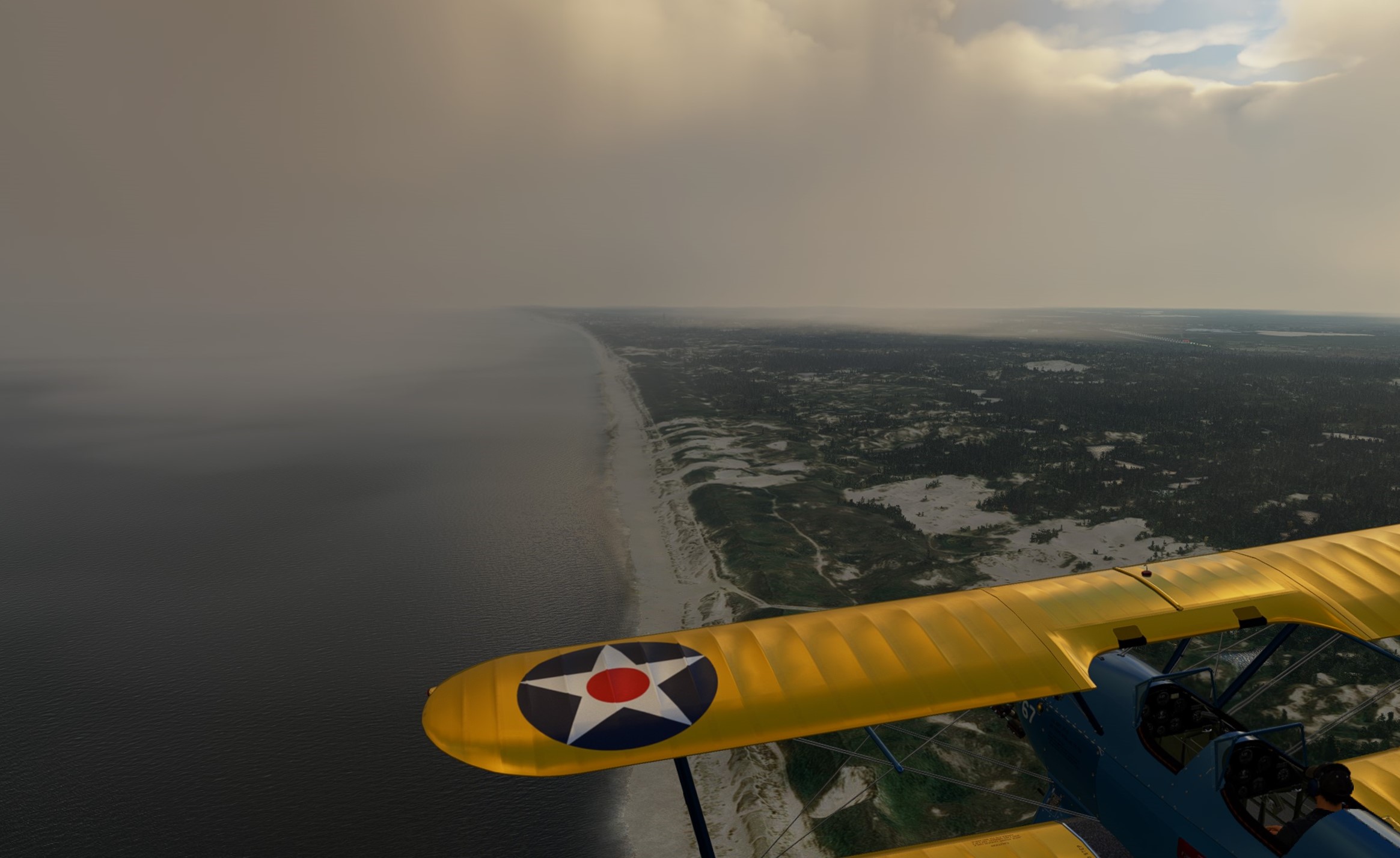
Becuase this flight is 99% over water I am using ‘live weather’ to keep things interesting. Should have thought about this a bit more!

Approaching my first waypoint and I still have solid overcast. Descending for a visual nav fix with the ‘ever reliable’ Mk1 Eyeball, I break out at… I dunno, about 8,000ft (the altimeter on the P-38 is conveniently hidden by the left hand yoke grip :see_no_evil: )

Hopefully that is the Western edge of Manus Island. Intermediate waypoint, site of an infamous Australian immigration detention centre and the last land I will see before I reach my destination. Nothing but 950 NM of open ocean from here. If I was doing this for real the pucker factor would be high.

Not a lot in terms of scenery between here and my destination unless you are really into lo-rez clouds, so here is a selection of a few more lo-rez screenshots of what is a remarkably well modelled aircraft (I wish I had the hardware to do it justice).

And after a while. Well actually very little time at all in front of the PC, but all day if you know what I mean… I make no apologies for extensive use of the ‘p’ key and ALT-t function for this leg
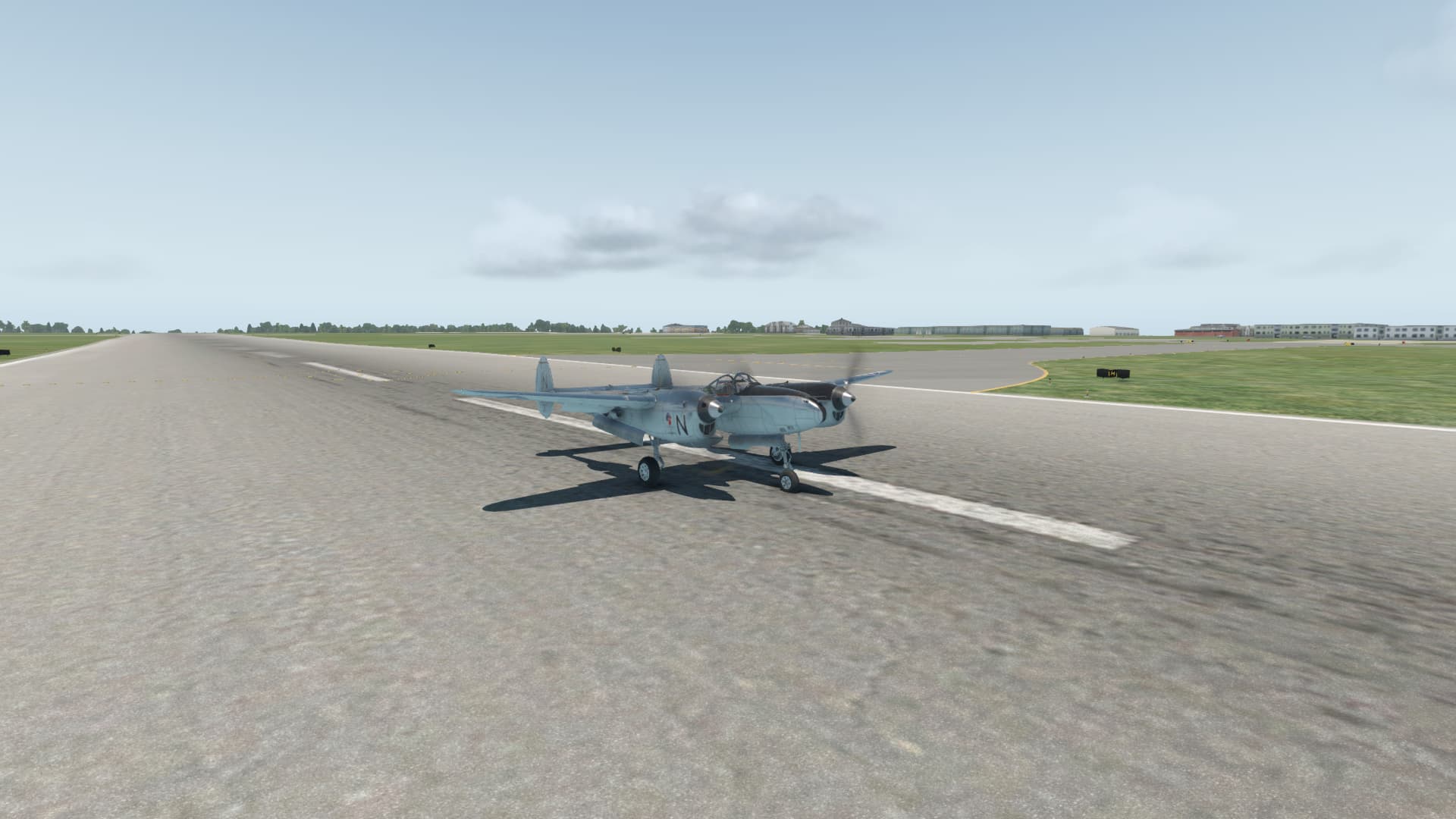
I actually made it.

On approach, landing and parked at Anderson AFB. Drinks are on me in the O Club, enlisted invited :wink:

I hadn’t spent a lot of time with it before but this is now one of my favourite XP11 aircraft. The flight model ‘feels’ unique enough and if you actually take the time to RTFM and ‘fly the numbers’ it isn’t all that difficult (note: and I can’t emphasise this enough… I am not a real pilot).

I might even make it to Svalbard by Christmas at this rate :crossed_fingers:

Hopefully, that isn’t just:

15 Likes

You should have landed in Tempelhof (might have to dodge some skaters, bicycles and watch out for kites). From there you could almost walk to Curry 36.
And be aware, Berliner Weiße is for tourists only :wink:

4 Likes

That is one gorgeous aircraft! The phone/tablet holder is a brilliant idea, I was just watching Chris from Military Aviation History’s latest In the Cockpit episode featuring P-47D “Bonnie” that has been restored with all the old cockpit instruments and just a couple of modern radios and what looks like a small GPS hidden away in spare places on the instrument panel - but the P-38 has a yoke! Genius idea to simulate a tablet holder!

And they have an MSFS version… no I must be strong - I started in a King Air and I’m going to finish in a King Air!

And much kudos to you for flying that distance in aircraft like those (even with Alt-t!) - I’m programming the FMS and the autopilot’s basically flying everything except takeoff and landing… and the occasional sightseeing opportunity…

5 Likes

Just for comparison:

(picture taken an hour ago)

15 Likes

Yep. The button on the ‘tablet’ actually toggles the Garmin, which is hidden behind the yoke, on & off. But X-Plane allows you to also toggle the yoke on & off so I still had a nice magenta line to follow :wink:

3 Likes

Go Get It Senate Judiciary Committee GIF by GIPHY News

8 Likes

First leg down!

For this trip I’m starting at LAX and will slowly make my way across to the Northeast, ending my North America portion with a launch out of Boston.

The European portion is largely dependent on time for how many stops I do, but ideally I’d like to take my time working my way north from Gibraltar or someplace similar.


This leg is just a quick flight over to Vegas, I’ll be flying a Delta 739 out of Terminal 2 at LAX.


It’s amazing just how far away you can pick out that sphere flying into Vegas, real world and in the sim.

Shut down at Vegas, next flight will be another Delta leg up to Salt Lake City.

14 Likes

Alright, here we go…and God help us! :rofl:

For some reason, I always have a difficult time starting the Holiday Flight.

Actually, scratch that. I know the reason…it’s because I usually come up with some kind of crazy ass plan that has almost zero chance of succeeding.

In fact, how I came up with this year’s journey into madness was so Byzantine and Rube Goldberg that even I can’t recall it in its entirety…much to the relief of you all, I’m sure. :wink:

But it looks like this…

…apologies to both @apollon01 and @PaulRix as I’m pretty sure that I stole both your ideas somewhere in here!

The other half of the plan, almost entirely unrelated and likely wholly incompatible with the first, crept surreptitiously from the depths of my increasingly nostalgic old man’s mind.

It occurred to me that, as a witness to the sunsetting of MSFS 2020, there were some aircraft that I had never flown in all the years I had flown it.

So, it seemed somehow appropriate that I should do so at least once, as sort of a tribute to the resurrection of the franchise many, including myself, had thought at least mostly dead.

miracle-max-princess-bride

So, the plan is this. I am required to fly every plane on this list, at least once, between ZUDC and ENSB. I make exceptions for same model, different configurations, so no requirement for skis/floats/wheels here.

As you can see, this is going to present a few challenges. Of the 30 (28 if you exclude the glass Cessnas) aircraft on this list, some will go very fast/far, but most will not. Some legs will pretty much define themselves. But others may only receive a token victory lap or two.

I tried matching aircraft to legs, but the ragged tatters of my sanity required that, were I to do this, I’d just have to go for it.

And so…

LEG 1: Daocheng Yading Airport, Daocheng County, Garzê Tibetan Autonomous Prefecture, Sichuan Province, China (ZUDC) TO Tribhuvan International Airport, Kathmandu, Bagmati Province, Nepal.

Well, let’s get this off on the right foot…

Katmandu - Bob Seger - YouTube

For better or worse, flying from East Coast US to Norway wasn’t going to give me a lot of room for all of these aircraft, so I decided to start from last year’s destination Daocheng. And the fact that two years ago it had been necessary to bypass a big chunk of the Near and Far East, including Everest, got me to make a slight detour 781NM west, to Kathmandu.

Back at Daocheng. Last year, I limped Lao Che’s Ford Trimotor into here at near full throttle.

OK, this might be more difficult than I thought. :thinking:

Found the gear handle and the Direct To button. What more do I need?

Well, this ain’t no Trimotor. We got out of here in a hurry!

Not gonna lie, both the Himalayas and the Citation look beautiful here. Say what you want about MSFS 2020, they sure made it pretty!

It took a bit of trial and error, but I eventually got everything coupled up, Anti Ice on, seat belt sign off, coffee brewed.

The, seemingly inappropriately named Dri River. As far as I could get the map to tell me, this will eventually lead all the way out to the Bay of Bengal. I tried to pick out the flats of India in the distance, but the scale was deceiving. Those lowlands are still hundreds of miles away.

Thunderstorms started brewing over the mountains as I continued west. Forecast (and it was nice to see, accurately), but still a concern for my spotting Everest.

However, mostly by chance, my flight path was going to take me almost over it. Even at almost 100NM, it still seems like it wants to burst forth from the cloud deck.

And there she is!

There was also a non-zero chance I may have had a small sense of humor failure when I was trying to find Everest on the chart.

Not sayin’…just sayin’. :person_shrugging: :shushing_face:

Well, that milestone behind me, I now needed to worry about landing.

The weather, it seemed, was not going to be accommodating.

I got the VOR 02 loaded and tuned in (no small feat). But, not having the approach plate up was a rookie mistake here.

The “milk bowl” I discovered after breaking out of the clouds, was not going to help.

When I did spot the field, I was high, like fire at the medicinal Cannabis dispensary high.

And don’t think I wasn’t looking at the mountains on the far side of the valley either!

Since a straight in was, at this point, pretty much out of the question, I came zorching into the downwind with all plain sail (and grandma’s bloomers) hanging out to slow me down.

A “Bank Angle, Bank Angle” tight, throttle in the bucket, overshooting (but other than that, textbook :rofl:) approach turn and I finally git her lined up on final.

To plunk her down with little further ceremony in Kathmandu.

Alright, well that was a thing. 781NM, about 5 of which could be considered downrange travel!

Well, as I said last year…

We’re off to the races!

14 Likes

Uh Oh Wrestling GIF by WWE

10 Likes

Moving on from Rotterdam do Texel, the southernmost of the West Frisian Islands. This looked like a rather short leg and moreover a scenic one which called for something slower to take in the views. And as I have a Stearman from two different developers, I took one for the spin.

Den Haag.

I was in the mood for a relaxing VFR trip north along the Dutch coast. So far so good but soon the “V” portion got challenged.

Wet, grey and low hanging clouds? Who needs an artificial horizon anyway!


(Simrate 2x did not help much either)

Made it through

Not again!

Texel on horizon

My instructor once told me that he was stuck in Texel for a week with his experimental homebuilt as the weather was solid IFR and the low pressure refused to move. This screenshot brought his story up.

Texel airfield. No wonder they all sit in the bar today.

Could not make up the runway so I just landed into the green.

Busy field!

I failed to find space reserved for vintage so in the end parked the Stearman next to this little white red beauty.

Next leg brings me to Helgoland in Germany. Apparently it is a very nice place so the weather better plays the ball. I might as well take something with an autopilot just for a good measure!

14 Likes

Well that’s a solid route choice.

Nice Case I recovery, too.

5 Likes

bananas

3 Likes

Can I ask something?
let’s say I want to see how the good old FSX holds up with my PC- Windows 10 and 3070Ti…

Where would you guys get the FLIP to do the Airfields procedures?
Are there free online resources?

3 Likes

Skyvector (https://skyvector.com) is a good start for flight planning and charts.

I’m running X-Plane 11 and I can export a flight plan from there and import it directly into the Garmin FMS. I don’t know how, or if, you could do that in FSX?

5 Likes

That’s brilliant! Thanks you

It’s also not impossible to Google something like “Heathrow Airport approach chart” and find some old pic of it still on the web.

The question may be, do all the freqs still match for VOR/ILS.

3 Likes

Be prepared for it to run badly though.

For some reason FSX runs quite poorly in general, even on quite new hardware.

3 Likes

LEG 2: Tribhuvan International Airport, Kathmandu, Bagmati Province, Nepal (VNKT) TO Saipur Airport, Rangpur Division, Bangladesh (VGSD).

Well, no time for navel gazing (see what I did there? :rofl:). I need to get a move on.

I tried to split a few hairs here. I am going to need to be aggressive in working my way through the GA stable, so I don’t wind up with 100NM to Norway and 25 aircraft that I still haven’t flown. But, I also need to eat up some miles. I was going to shoot for Mandalay, but my behind told me that Saipur was as far as it was going to take me, 223NM.

To start checking off the list, I went with Lil’ Lightnin’ here, the Diamond DA-40; old school edition.

After seeing the mountains baaaaarely through the clouds, I almost changed my mind to something with Synthetic Vision, especially since I scarcely knew how to program the GPS.

But where would Colombus have been if he waited for Synthetic Vision? Other than safely in Genoa without Scurvy.

But I digress.

I really like this little plane. Light and peppy, she leaps off the runway, even at this elevation.

I’m trying to climb her above the MSA to the south, which she does reluctantly. Had I been willing to mess with the GPS, I probably could have flown a SID which would have been a little less…guessy. Still, I’m not quite socked in, so I’m feeling optimistic.

The view out this canopy is bananas! Over my left shoulder are the Himalayas, stretching to Heaven. I highly recommend this flight…the picture just doesn’t do it justice!

With the luck reserved for old men, children, and Marines (and, depending on whom you ask, I qualify as all three!), I find myself over the Sun Kosi River valley and safe from all but the softest and most fluffy rocks.

And eventually free of the worst of the mountain obscuration.

After clawing my way out of the Himalayas, I eventually come to the Indo-Gangetic Plains. Here, the Sun Kosi veers off to the left as the Mahananda cuts across my nose to make its way down towards the Mouths of the Ganges.

Or at least that all sounds good…I still can’t find a decent atlas. So, this may all be BS! :grin:

Things start to look a little sketchy as I enter the plains. It occurs to me that this probably is the Monsoon Season.

And soon enough, I’m in it, for reelz. I think I’m missing most of the convective stuff, but that can be difficult to discern in the sim.

Learning my lesson from last time, I busted out the RNAV 16 chart. Now that I am flying an aircraft that has an FMS and am running Navigraph, I may have never been better equipped in MSFS!

And it looks like I might need it. One last cell over the IAF.

Remarkably, though it was looking pretty ick there for a while, I break out on final and it’s a smooth path to the field.

I really appreciate the way that the buildings look here. Very region appropriate I’d say.

And that’s it for leg 2.

12 Likes

Nice flight! I’ve chosen an aircraft that even has ice protection, and so far I’ve flown near a single rainstorm and less than half an hour at night :joy:

2 Likes

Part Seven - This should be Epic

I looked at a number of ways to get from here to the Land of the Rising Sun. Basically using Iwo Jima or Kadena as stepping stones and I even contemplated a diversion to Taipei via Manila… But I have enough miles to cover as it is.

For ‘reasons’ I just had to fly in to RJTT at some stage of this journey, so I might as well get it out of my system now.

This will test the claimed range of 1650 NM for the E1000 but I am pretty much going to be overflying RJAW anyway, so I at least have options if my ambition exceeds my ability.

Yeah, I didn’t think it would be long before I was back in this particular aircraft either :wink:

Back in a ‘civilian’ aircraft, so I am departing from a civilian airport this time - PGUM

Reach a nice cruise altitude AP on and let the aircraft fly itself.

solid overcast for most of the journey, again, so here are some shots to showcase what I think is a very nice looking plane.

Cleared somewhat with about 2/3 of the distance covered.

But a bit ‘soupy’ for approach and landing.

Fuel was tight

Landed and parked.

At least I am making progress.

13 Likes