The official 3rd Annual Mudspike Christmas Flight - 2017 Edition

Looking in my stable whats left, I decided for the PA46 Malibu Mirage, so I will make a complete use of single engine aircrafts before moving to multiengine.

I actually dont know much about the great looking PA46, but I have quite a distance in front of me so I will learn on the go. You know time constrains :slight_smile:

I lazily climbed out of the Baghdad and planed to turn waypoint over Strait of Hormuz (quite popular destination I would say :wink: ) and finish in Pakistan, Masroor AB. Dist: 1318nm

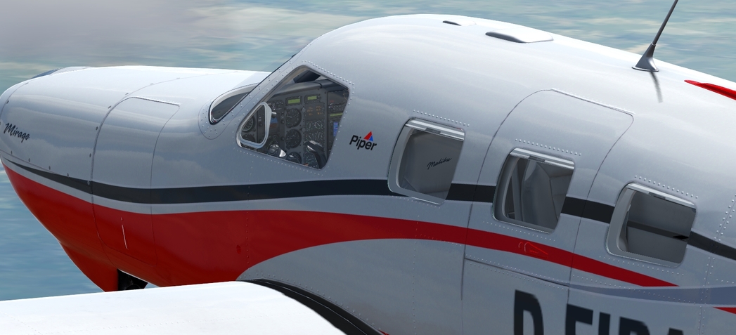
PA46 looks really agile and also the Dovetail graphics team did a great job on her

Stunning from every angle…

…inside out (on the right side can be seen blue waters of Persian Gulf)

I climbed to the cruising alt, around FL019, and played with the mixture control as the engine was loosing power.
In the hurry and without any useful docs I set the mixture based on the only gauge which possessed at least minimal will to move when I moved the mixture control.

So actualy what I did I set the mixture to the position where that gauge needle pointed to its maximum value without closely checking.
As I later discovered, it was Fuel Flow gauge! :smile:

But it was not at this point. Strait of Hormuz, ‘Wish I had the time to stop for a while to check closely’ went through my mind

It was at this point where I overflown the waypoint and was fiddling with GPS and HDG to set my next course.
My eyes hovered for a while over two gauges which needles pointed straight to the cockpit floor… Fuel Tank Indicators :thinking:

…switched to SkyVector looking for some nearby airport. There we go, right on the peninsula… but without nav aids… :thinking:
GNS530… nearby airports screen… OOKB Khasab (didnt know that the North part is Oman)… Direct To…

Fought a battle with the AP to set the descent to aproximately 1000fpm. The best I achieved was cca 500fpm. Disconected the AP and went with manualy controled descent.
The guess was quite right, descent went smooth (notice the fuel gauges, only two needles pointing sadly down)

As I am cruising not at my gaming PC, but via TeamViewer from my laptop, I had to save the flight (and the day) right when the airport popped up from the dirt. Gray-ish airport on the cream-ish surface

I did good decision. Because without the proper controls (joystick and throttle) using the laptop keyboard I would just jink right, jink left and crashed on the approach. Morning is always wiser than the evening.

Next day with calm head I overflown the treshold and did 270 turn around the small hill (treshold right below me)

And made it in one piece (of cake not so much) :wink:

With full fuel tanks I made around 850nm instead of the planned 1300nm. What to say…

Welcome to the club! :sweat_smile:
1Percent_clear_background_JPEG

5 Likes

Nice to see another DC3 on this trek… that’s three of us now by my count. :sunglasses:

Chubu (RJGG) to Tanegashima (RJFG).


This flight takes us just beyond the most Southern point of mainland Japan.

Departing Chubu airport turn to the West over Ise Bay.

On the other side of that ridge line we should be able to see Osaka.

The stock scenery in this area looks great to me.

The city of Osaka, looking Southwest along the Yodo River and the Osaka Bay.

Something makes me think we are directly over the Osaka International airport. Looks like World Traffic 3 is doing it’s thing too.

When I first saw the scenery around the Osaka port area and here, looking towards the Kobe airport, I thought it was pretty shoddy work, and not at all natural. Well, after looking at the area in Google Earth, it really isn’t natural at all, but instead, reclaimed land…

Leaving Kobe and Osaka behind us, we continue Southwest.

Crossing Awaji Island, the cloud layer started to thicken up and get lower. I descended to stay visual with the ground.

With high terrain looming ahead, it was inevitable that I would have to climb up into the murk.

Once I climbed up, it turned out to not be so bad, with the cloud layer starting to break up a little.

With the high terrain behind us, we soon come across the Kochi airport.

The city of Kochi and just to the South of the city, Urado Bay.

Some time later, we have crossed the Bungo Channel and turned South. Looking behind us, we can see the city of Miyazaki, with it’s airport runway sticking out into the sea.

Coasting out. Looking to the right, we can see the mouth of Shibushi Bay.

While ahead we get our first glimpse of Tanegashima Island.

As we get a little closer, the island seems relatively flat with no significant mountainous terrain.

About half way down the length of the island, the airport comes into view. The winds were pretty much calm, so I turned onto final from a left base for an uneventful landing.

My next stop will be Okinawa, hopefully this weekend.

5 Likes

@Sine_Nomine Oh my, that’s quite the adventure! What’s the name of that game, out of curiosity?

@PaulRix I think your AARs have to be among my favourite. I like how you point out all these landmarks, really makes it a fascinating read. The Japan stock scenery looks pretty darn good in X-Plane, eh? I can’t say the same for the Montreal area, unfortunately. They made it look like a huge forested island… while in reality it’s one of the most urbanized areas in North America. :wink:

1 Like

It’s good to be back in my trusty work horse. Now what direction is Australia again?!

7 Likes

Lol :joy: - Fantastic @Sine_Nomine.

2 Likes

I think it’s time to move the post of the year badge…

Seconded?

6 Likes

Aye, seconded.

2 Likes

Sorry, we could not calculate directions from “Kanton Island, Kiribati” to “Christmas Island, 6798”

2 Likes

Badge allocated - the coconut morph gif swung it for me.

7 Likes

It’s a cool honor and we’ll deserved, but be careful. For some reason they made it out of the biggest rock in Beach’s backyard. That badge is heavy with expectation…

4 Likes

@Sine_Nomine as is now emergent tradition, you now have the responsibility of nominating who gets it next (with a second agreeing also). I mean I just made that rule up, but it seems like a nice idea. :slight_smile:

5 Likes

Correct, it is stock FSW scenery on my pics. Dovetail is advertising that they had ‘Integrated the critically acclaimed Orbx FTX Global textures’. But I am critical to some parts of the world textures quality.
So will have a look on the Kritimati and post some screens.

And thx for the spartan sources :slight_smile:

1 Like

This is how Tyranny starts! Although I do not fancy you a Caligula. Perhaps a slightly less impressive Claudius :wink:

I’ve saved a flight with the CIVA IV INS last night, unfortunately X-plane 10 is not capable of saving the configuration, and on reload the aircraft is going a bit weird in the cranium when it suddenly has to make sense of it’s existence. Any advice? Do all custom navigation tools suffer from this? Could I use X-FMC with the 727 with more success?

Reinforced with Piper Malibu Mirage information manual (thx @chipwich) I was ready to push the performance of this aircraft to its proclaimed (as loosely remembered from FSW pilot operating handbook) envelope. As I realized after landing, its was little beyond :slight_smile:

So it is again obvious that my planning was sparse as the virtual scenery around my departure airport OOKB Khasab.
As already mentioned, located on the northern part of Arabic peninsula, it is governorate of Oman.

Planned distance little bit over 1400nm. It is possible, at least I believed in it before departure.
As this journey is about peninsulas, islands and atolls pls notice that the destination is small atoll called Agatti off the South West coast of India.
Of interest is this information - The airstrip [on this atoll] was constructed during 1987−88 for operation of Dornier 228 type of aircraft and was inaugurated on 16 April 1988

I stayed just overnight and woke up early to see the sunrise from some FL. Virtual departure time almost matched the real time, I really woke up 05:00 this morning to start this flight

Established the cruise at FL200 and smoothly went from one cruise regime to another. Started of course with the High Speed Cruise, went through Normal Cruise and settled somewhere between Economy Cruise and Long Range Cruise. Slowly you will go further…

Turned my waypoint over Masroor, PAF AB in Pakistan. It was home of Starfighters. Pilot of the preserved F-104 at the AB, S/L Bhatti, claimed shot down of Indian Su-7 Fitter on December 4, 1971. Wish we have 104 in DCS :slight_smile:

Then followed little the North West coast of India to my destination. The most part of this leg was over the ocean

We made it. Only 5% of fuel left now, but Agatti in sight

What to say about the island (and FSW scenery around here), nothing special. Even the airport is on the wrong side of the island… but I am happy to be here anyway :sunglasses:

2017-11-08 22_17_01-Musandam Governorate - Mapy Google - Avast SafeZone.

Was great to push the Mirage to its limits, using the manual finally of course. Landed with 4% of fuel in the tanks. Distance covered 1477nm. Short look into the FSW POH provided me with small surprise - Range: 1343nm :innocent:

7 Likes

Nicely done NEVO. That Mirage is a great looking aircraft inside and out. Looks like you pretty much double your mileage from the last leg.

I can’t find any online references to it now, but back in the late 90’s the Georgia Tech school of aerospace engineering, sponsored a Piper Malibu in an around the world race. I attended a photo presentation (no GoPro back then) and their story was fascinating. To fill their wing tanks, the students jacked up one side, filled the downhill tank, and then repeated the process. The configuration was not in the PIM, but by their calculations, they could get airborne, using all of the tarmac. They also had some sort of satellite link with voice and positioning data with a tracking station back in Atlanta at the university, The ground station advised them of their route with regards to the weather, giving them quite an edge. This was long before hand held GPS and real-time WX that we now take for granted.

Test flight from Innsbruck to Rome, trying out how to work with X-FMC.

Haven’t flown over the alps before, it’s gorgeous!

4 Likes

While I had some downtime in Christmas Island, I decided to fly around Papua with the PMDG DC6 and come back.

WOW… that aircraft is amazing!!!

Engine start-up was daunting at first but it wasn’t anything I hadn’t seen before in other sims with aircraft of the same era. Starting for engine 3… Battery ON, Crack throttle half an inch, Prop Lever to FULLY FINE, Mixture to AUTO RICH, Booster Pump to LOW, Fuel Lever to MAIN TANK, Ignition switch to BOTH, hold starter switch, wait for 3 prop blade turns, set the priming switch ON, wait for 9 additional blade turns (you should be at 12 by then), set the BOOST switch to ON, and the engine finally roars. The whole plane shakes like crazy. I let the oil warm up, and set my cowling flaps to TAKEOFF position. set my gens and inverters ON, set my hydraulic pump on, set my flaps lever to 15 and before you know it, I’m up in the air, marvelling at that incredible plane. Still haven’t figured out how the autopilot and the Garmin 430 work, but I’ll be sure to learn more about the DC6.

Seriously, I highly recommend it. It must be so much fun flying in Alaska and the Canadian Rockies in a plane like that.

7 Likes

Heading South towards Cis-Alpine Gaul. Not exactly VFR weather down there!

3 Likes