Ah…through sheer persistence and volume of paperwork, even the FAA ship can be turned. I should brush up in the ATC 610, I’m being observed in December on my King Air sim ride…or rather…the check airman is being observed administering the check ride. I’m thinking about doing a Split-S as my procedure turn for the mundane JFK VOR 4L approach.
Leave it to the pilot to find the brothel. Might need to run a side Mudspike Air Cargo run in with some penicillin…
It’s like Elite Dangerous…hundreds of years ago…
I love the rum added point bonus. As it well should be.
Winging my way across East Texas…going to drop in to the location for one of our FEMA deployments last year…
How’s that for odd. Flew all day in real life, come home, go flying. Nuts.
Eighth entry for the Christmas Challenge.
Panama to Columbia, this time.
Click to reveal AAR
This time, I’m going solo in Just Flight’s English Electric Canberra PR.9.
That’s one sexy plane. A bit uncomfortable for the navigator though.
I scribbled a couple of notes to get me going.
Setting my throttles to OFF
Exploring the electrical panel
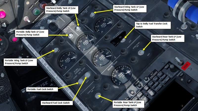
Checking fuel tank layout before refueling to 18,000 lbs
Ready for engine start
Better make sure I don’t forget these fuel cocks as well (So many cocks!).
Good start!
Gotta run through some last checks again.
Finally ready for taxi
Entering the flight plan
Ready for takeoff
Recommended procedure for takeoff:
Takeoff:
Except under conditions of operational necessity, limit take-off thrust from each engine to 90% RPM.
Climb:
If a sustained climb is intended, allow the speed to increase to the full throttle safety speed (170 knots) then set climbing RPM and increase to climbing speed. For circuit practice it is recommended that the speed be kept below 220 knots. For the climb to circuit height, 80% RPM is more than enough.
I take a deep breath and start throttling up to 90 % RPM
Unstick speed should be somewhere around 130 kts
These Avon Mk 206 engines are powerful as hell
Climbing like a rocket
Overflying Tocumen
Climbing some more
Lots of clouds
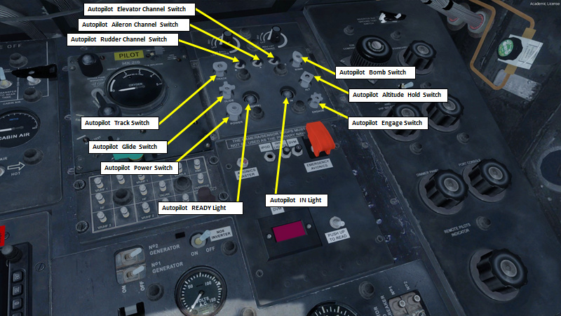
Notes on Autopilot
- After engine start, ensure flaps are UP and No. 2 inverter has cut in before starting checks on AP
- Pull on the POWER switch and check that the READY indicator shows black/white stripes after approx. 1 min
- Switch IN rudder (set to RIGHT), aileron and elevator channel switches
- Ensure trim indicators are within white sector and trim the aircraft to fly hands and feet off in the required flight attitude
- Pull ON the ENGAGE switch and note that the IN indicator shows white and the READY indicator black.
- CLIMB/DESCENT: disengage the ALT switch, move PITCH control to achieve necessary pitch.
- ALTITUDE LOCK: When flying straight and level, engage the ALT (Altitude Lock) switch.
- TURNING: Use PRE-SELECT TURN ENGAGEMENT button on the compass repeater
- To disengage, set ENGAGE switch to OFF, then push OFF the POWER switch.
Autopilot ready (POWER Knob pulled, READY light hatched)
Autopilot Engaged (ENGAGE knob pulled, IN light white)
To control heading, we set the desired heading with the Autopilot Heading Setting knob, then we press the Pre-select Turn Engagement button.
We control Autopilot pitch with a small DIVE/CLIMB switch.
I think I finally got this autopilot thing figured out.
Reaching 25,000 ft. Let’s see if we can make it to 42,000 ft. I hear the Canberra PR9 we have can get up to 48,000 ft!
So far so good
Some data on fuel. Better keep an eye on those fuel gauges.
Reaching 34,000 ft
Flying over the Reserva Forestal Punta Patino, I can barely hold 38,000 ft. However, that might be because I’m very heavily loaded on fuel and unwilling to push the engines past 90 % RPM.
The beginning of the Andes Mountain Range is completely covered with clouds
A little looksie at the GPS
Over Medellin
So many clouds
Approaching Cordillera Oriental
Starting my descent, deploying some funny-looking airbrakes on the wings
Diving into the soup
Rio Magdalena. Catching some light rain on the way
Starting the approach. I gotta be careful: Bogota is about 8350 ft high.
Those are some really terrible conditions now that I think about it…
I tune my ILS frequency to 110.7 (Runway 13R)
Aaand… there’s a signal! Yes! Let’s hope I can remember my ILS approaches in the VEAO Hawk.
Crew-only being approx. 29,000 lbs,… with approx. 13,000 lbs of fuel remaining… that gives about 42,000 lbs total, which gives a threshold speed of about 105 kts. Approach speed is threshold speed + 15 kts, so 120 kts.
Oh my god… am I really gonna land into THAT?
I keep saying “8350” out loud to remind myself that the airport is at that altitude. I need to be exceedingly careful since the runway is on top of a very steep cliff. Coming in too low means crashing into the mountain.
I also need to be extra careful to land as smoothly as possible. The landing gear on this plane is really, reaaaally low. A tail strike is certainly possible if I try to flare.
Runway in sight
(Clenching Buttocks)
I’ve got to be butter smooth on that one
Touchdown
Wow… I did it! I can’t help but feel an exhilarating sense of accomplishment.
Taxiing
There we are. We have finally arrived to El Dorado Airport in Bogota, Colombia.
Shutting down engines
Great report. 50’s Cold War jets…
Up next leg 3 KATL to KLAX
We will be flying a 767 with 261 people and hauling 49,336 lbs of hunting clothes, household goods, and drums
Holding short of the rwy at KATL awaiting clearance.
Climbing out west in some beautiful weather,
Up next a Thanksgiving day flight to Hawaii
Yes. You appear to be surrounded by cocks.
Yeah…that is a no joke airport where you have to be careful…
Up next leg 4, KLAX to PHNL
We will once again be flying a 767, we will have 250 people on board and hauling 51284 lbs of generators.
Holding short awaiting clerance
Still climbing but turned north so we can pick up the R576 airway
ATC seems a bit drunk, not sure a 767 mixes well with a water runway
UP next the final leg of our journey, PHNL to NSTU
but first the thanksgiving day feast!!!
Happy Thanksgiving to all who celebrate it and to those that dont, I hope you had a wonderful Thursday!
Remind me not to go on any adventures with @Sine_Nomine - trouble seems to find him! Whether being becalmed to the point of madness in the Indian Ocean or being chased by pirates…he has a very Indiana Jones way of finding trouble…
I already know what @Sine_Nomine’s next leg of his Christmas flight is going to be like…
Ninth entry for the Christmas Challenge.
Click to reveal AAR
What do you mean, “My TBM-900 is grounded?” I screamed at my boss.
-We mean that this great TBM-900 you wanted to fly is currently having issues with X-Plane’s current beta.
-You’re kidding…
-Nope. You’re gonna have to pick something else while Laminar works on a stable version.
-Don’t you know who I am? I’m the guy who -
-You’re a nobody. Shut your yap and pick another plane.
-Well, then… I’ll go with a 737. You can’t go wrong with a Boeing. Do you guys have a -700 somewhere?
-Good kid.
-Okay then… let’s do this. I know a guy who liked that plane.
Taking the United livery for that one.
IRS Alignment
Starting pushback
Lining up on 31L
Flaps 5 takeoff
Rotating
Gear up
Here’s that big cliff we almost crashed into last time in the Canberra
Feels good to climb in these clouds with a modern autopilot at the helm. That ILS approach in the Canberra was not very pleasant.
The sun rises over Lake Del Muña
Beautiful
The morning fog lifts
The climb to GIR looks a bit odd…
Turning (Cinematic Mode: Activate!)
Contrailing
That’s a shade of blue I don’t get to see often
The Puracé is an andesitic stratovolcano located in the Puracé National Natural Park in the Cauca Department, Colombia. It is part of the North Volcanic Zone of the Andean Volcanic Belt. The volcano is located at the intersection of the Coconucos and Morras Faults.
Approaching Cali
Approaching San Luis Airport (SKIP), the 27th highest airport in the world at 9764 ft above sea level. The airport is right after the Páramo de La Paja Blanca, which is a plateau. In more exact terms, a páramo is the ecosystem of the regions above the continuous forest line, yet below the permanent snowline.
As I start my descent, I see that I can’t seem to hear anything from the ATIS freqency. Strange… I consult an online METAR for Mariscal Sucre.
More clouds on the way down
Cayambe Volcano
As I come on final, I realize that something is not right. I can’t get the ATIS frequency, but I can’t get the localizer either.
I can either do the following:
a) Try to land in zero visibility conditions and follow my flight director to what I assume is the runway, even if I don’t have a localizer or a glide slope captured
Or…
b) Go around, climb up and check my database
I elect to go around and climb back to 11,000 ft and enter a holding pattern. The database seems to tell me that there is an airport, but nothing leads me to believe that there is an actual airport. I have a feeling… oh no. Not the Bangkok Phantom Airport episode again! Could this be possible?
I check the Map and see that no SEQM airport exists, but an airport of the same name SEQU exists, but with different frequencies for everything.
And here’s the culprit: the defunct/old Mariscal Sucre airport (SEQU) is in the simulator, while the PMDG 737 database (which dates from early 2017) has the new Mariscal Sucre airport (SEQM). The old Mariscal Sucre International Airport ceased all operations at 19:00 on February 19, 2013, which makes sense since Prepar3d uses the old FSX database which dates back from the early 2000s.
Luckily, the Map menu also gives me the frequency for the Quito Tower.
I contact the tower on the new frequency (118.1). I get asked to enter a transponder squawk code of 0113 so they can have my aircraft on their radar. Then, they give me directions towards the airport (at my three o’clock).
If the airport is to my right, I can only assume that I will have to take runway 35. I will have to tune in to an ILS frequency of 110.5 for runway 35 with a course of 352. I have to be careful though: the altitude is now 9228 ft.
With the new Localizer frequency
Ah ha! We have a signal now. I’ll home on that one. Hopefully we get to land on a real airport this time.
Terrain radar says: you’re playing with fire.
I can do it. Come on!
I get my landing clearance for Runway 35. (Taking a deep breath)
Moment of truth
Almost there
However, during the last few seconds before touchdown, a succession of huge wind gusts pushes me up. and the cockpit starts shaking violently. I ram the throttle forward and abort the landing, going around. The wind turbulences make an autopilot approach almost impossible since the wind gusting create an airspeed variation of +/- 15 kts, which messes up the autopilot and autothrottle inputs since they rely on the pitot reading to give their corrections. In that case, I would bet that the safest course of action is to aim for the runway myself and disregard the airspeed gauge when it varies too much with the wind gusting. That means: I may be going a bit too fast, but at least I’ll be able to manage my attitude correctly.
TLDR: I’m gonna have to try to land this aircraft by myself. (Gasp)
I swing around, do another circuit and I come in a bit lower, a bit hot but this time I have much better control of the aircraft since the autopilot doesn’t move the yoke with the wind gusts.
As I am about to touchdown, yet another wind gust pushes me up again but I firmly keep the nose down. The aircraft accelerates, but the spoilers kick in and the autobrakes do their thing as the main landing gears touch the ground. I see the end of the runway approach dangerously fast. Like… REALLY freakin’ fast. This is one of these times where you have a split second to make a decision: commit to bringing the aircraft to a full stop or going around (even if that could mean running out of runway length). Instinctively, I set the Autobrake switch to MAX instead of 3 and deploy the reversers to MAX.
The aircraft doesn’t seem to slow down. I hit the brake pedals in panic mode. Then, the aircraft suddenly starts to decelerate quite rapidly. Mere meters before the end of the runway, the aircraft comes to a full stop. Holy cow… that was THE most intense landing I’ve ever done. My hands were shaking, my palms were sweaty… It’s just as if I had been there.
As I start taxiing back, another aircraft takes off.
As the passengers are about to disembark, I start thinking about all the things that went wrong and all the things that could have gone even worse.
Here are the things that went wrong:
- The fact that the airport I was planning to use didn’t exist in Prepar3d really screwed up my carefully planned approach.
- The terrain in Quito is quite difficult: lots of mountains (one of them right next to the runway) and lots and lots of winds.
- Weather was just overall not good and visibility was poor, forcing me to perform an ILS approach which I had to do manually since the autopilot became unreliable with the heavy gusts.
- I wasn’t familiar with the area. I had a good reflex to contact the tower and be given directions towards the approach, but I should have been more prepared (and I should have planned for an alternate airport, which I didn’t).
- The runway length looked good on paper, but I know I came in about 10-15 kts too fast. Speed was difficult to manage and I took an enormous risk. All was well in the end, but in retrospect, it didn’t seem like the best course of action. I think I should have found an alternate airport if weather permitted an easier landing.
- I failed to check if I had enough reserve fuel for an alternate airport. I was aiming to have a reserve of about 10000 lbs, but the go around and difficult approach (the winds forced me to approach with engines at high revs) That was poor planning on my part. When I landed, I had about 2000 lbs left of fuel. Definitely not enough.
So overall, I thought I’d give a quick shoutout to @smokinhole .You taught me much about the 737 back in the early days of the “Boeing Chuck Guide” and I remain thankful about it to this day.
Yes, with these sims one need to check in front what do exists in game and what doesnt. I usualy have problem with navaids, recently I noticed some missing NDB in XP11.
Maybe update of the navaids database will help? Never played with it.
Chuck what weather engine you use in P3D ? Is it something 3party or is it default?
I use Active Sky Next for P3D, which is a third party add-on. This has to be the best weather add-on I’ve seen yet for Prepar3d and FSX. It takes online weather reports and injects it in the simulation…I often compare it with what I see in CYUL when I get back from work and it’s surprisingly accurate at times.
It’s probably not be the same one but I crashed one of those when I was 16, 1981/82 time frame. They were showing it in a mall and letting everyone try it. Me being a kid I listened long enough to get it in the air and then I tried to loop it. Next thing I know the ball was tumbling and the salesman/instructor was asking me to leave.
Wheels
One short leg, one long leg. Here’s the overall flight plan for this post:
184 NM from Taipei down to Hengchun, and from there 936 NM to Davao in the PI.
We’ll be flying the JS 4100 again, with a full load of passengers and cargo, we’ll be taking off right around max weight. However there is plenty of reasonably cool dense air to work with here at sea level, so with a careful eye on the engine instruments, throttles forward.
Once we get the call of positive rate of climb, we clean the AC up, set climb power at 98 % RPM and max temp, and get a VS of ~1500 FPM. We’ll cruise at FL16 on this trip. Due to the humidity we might get some icing, so we’ll keep an eye on that.
As expected the FSX default terrain isn’t stellar, but at least there is some conture to keep it interesting.
As you can tell by my setup here, trying to hand fly the approach and take pictures was giving me some issues lol. In the interest of expediency I pushed this one down, even though a go around would have been a much better option.
Surprisingly I managed to salvaged the landing, though it was definitely a bit off center there. This was a quick easy flight, and really what the JS 4100 was designed for, commuter work.
I’ll put up details about the second leg this evening. However until then…
Tenth entry for the Christmas Challenge.
Click to reveal AAR
The Boss takes a deep breath.
-I heard that you didn’t land at the old Mariscal Sucre airport last time… is that true?
-Well, sir… it didn’t exist!
-What do you mean, “it didn’t exist”?
-Well, there was nothing there!
-So you mean to tell me that I sent you to an aiport that just… that just “wasn’t there”?
-Yes, sir.
-You’re insane.
-I went there… there was nothing there.
-I don’t believe you. Are you sure you just haven’t made dozens of mistakes and look everywhere BUT the airport?
-I swear.
-On your momma’s head?
-Yes.
-You’re a madman, Mister Charles.
-I get that often…
-Well, at least you didn’t crash my plane. Your Christmas Challenge is starting to get quite expensive. I hear the MAD company is crumbling under debts.
-That wasn’t me, that was…
-I don’t want to hear it, Mister. Do you know how much it costs to get all these fancy planes in the air because you just want to look cool and take pretty screenshots to post on the internet?
-Umm… A lot?
-Wrong. “A lot” would be like last year’s challenge. This time, it’s “Too beaucoup”. Get me?
-Come on, now… I paid for these planes!
-About that… Your wife called… she said she’s sick of eating Kraft Dinner for breakfast, lunch and supper.
-She’s exaggera-
-Listen. We’re gonna give you something more reasonable.
-Reasonable… cheaper like what? A C152?
-No. Cheaper like something that’s completely free. You’re getting Manfred Jahns’ C-47.
Oh…
LSHIFT+5 shows the interface.
The checklist system works really well.
Right engine comes alive!
Taxiing
Waiting for an A320 to clear the runway
Setting up my navigation radios
Consulting some notes on engine power settings
Rudder effectiveness at 40 kts, tail comes up at 60 kts, accelerate to 85 kts, then rotate. Simple enough.
Taking off
The initial climb is quite difficult. The mountains are high and the air is rare.
Capturing the first VOR radial: QMS
3.4 nm from VOR QMS. Magnetic declination for Quito is approx. -4 deg
Switching frequency to VOR MNV. DME distance seems ok.
Climbing gets more and more difficult at this altitude
I find a small passage between two mountains
These mountains are truly a breathtaking view
Curse this weather!
Is this england or what?
Finally crossed the mountains
Look at all these flat lands. Yay!
Rain now… I can’t catch a break!
I recognize that lake. We’re on the right path.
Approaching Manta
Running landing checklists
Approaching at 85 kts
Touchdown
Vacating runway
Shutting down engines. Phew. Finally made it.
Up next the 5th and final leg of our journey, PHNL to NSTU
We will be fly a 767 with winglets, we will have 218 people on board and hauling 58215 lbs of baby clothes, guitars, fishing poles, fresh potatoes, and soft drinks
Awaiting a DC-10 to take off before we are cleared to depart
Turn west complete as we continue the climb
Through the storm and the island is in sight
Flying over the northern part of the island
Lining up on final, bit of a cross wind
Almost there and almost in the trees,
Great location to fly to for Christmas!
During my trip I flew 890 people and 164,769 lbs of cargo. I flew for 15.6 hours and traveled 7362 miles burning 181,557 lbs of fuel as well.
Alright as promised, part two, the long leg to the South end of the PI.
So what we have here is the Vickers Viscount, basically the first turboprop airliner (another freeware from calclassic.com, I hadn’t planned on flying half their planes on this trip, but now that I think about it…). The first flight was in 1948, and serial production began in 1953. The last known commercial flight was in 2009. Not a bad bit of service! The Viscount is powered by 4 Rolls-Royce Dart engines, the same as the Fokker F-27 I flew a few legs ago. They were one of the first viable turboprops and were used all of the place. This particular Viscount is a type 813, which uses the Dart 525, at approximately 1990 SHP, for a totally of a bit under 8,000 SHP at full power. The Viscount introduced things like cabin pressurization to commercial air travel, so it was pretty complex for the day. How complex you ask?
I’m still getting to grips with what all everything does, and how to operate all the systems (as well as figuring out what is modeled to what depth). This is the overhead, one of about 15 panels in this plane. The only major dig I’ve got on this freeware bird, is that there is no “takeoff/landing” panel view, it’s either the whole panel in your face, of the miniguage view. However as it’s really designed to fly high for long periods of time, I can moderately forgive that.
So with take trim set, prop’s locked into pitch, ADI engaged, fuel trims calculated and set, spill valves checked… There’s a lot to check and set. However once it’s all done, take off is pretty simple, one notch of flaps, throttles to the wall (watch for an overtemp), and rotate.
Post take off there is plenty going one, getting the ADI system shut down, the fuel system setup for cruise, getting on climb profile etc. Once you get to your cruising altitude, it settles down to the usual routine of watching the engines, watching the fuel, and making sure nothing unusual is happening.
FSX’s default Philippines scenery, nothing to write home about and not nearly green enough.
Descending is a stately affair planned long in advance. Fixed shaft turboprop’s are not happy slowing down and descending, so plan ahead! There’s another long checklist (fortunately interactive) for descent and approach. The Viscount does have the default FSX GPS gauge, but I flew this flight old school. IIRC I’m still riding the VOR in before going to the localizer.
So the my ground steering needs some work! I had to make 2 go arounds to finally get a good landing, as the almost complete lack of forward view was NOT helpful.
Overall this version of the Viscount is a fun plane to fly. It has a great feel of it’s weight, and a ton of system modeling. You can tell this was definitely a labor of love from it’s creators.
Delta - ruining Christmas for countless families. I’m all about some Hawaii though! Nice leg!