Noice! And also very courteous of you to fly into Central America unarmed…lest they think they are under attack.
Ish, lol. I’ve got a full load of cannon I can’t figure out how to dispense of short of arming and holding down the trigger. I’ll call it defense against unruly penguins.
1 Like
![]()
Very nice posts guys! I am getting off schedule not only with my flights but also with following your posts ![]()
This was my Hop no. 2 from Arcata KACV to Buchanan KCCR.
I was inspired by this FlightSim review (I also own this Piper for FS9) and fired up my FS9 = Loaded it onto USB an runing it on the laptop. Not bad performance I would say ![]()
Weather at KACV was not ideal. But it was VOR to VOR flight on AP so no worries
![]()
But it cleared bit around San Fran
![]()
I decided for KCCR because it has nice VOR approach. It is quite simillar to NDB approach I would say but little easier with the DME on board
![]()
As lot of you guys are flying via americas so I decided to catch an airplane at KSFO and return to EU. I will continue down from old continent via africa ![]() at least thats my actual plan
at least thats my actual plan
4 Likes
Leg 7: SCAR Arica, Chile to SCVM Vina Del Mar, Chile
Airborne at 0545 to continue southward down the long Chilean coastline…


Six hours and 900 miles later we make our arrival into Vina Del Mar…


Next stop: Balmaceda, Chile
Next next stop: Antarctica!
6 Likes
Paving the way!
@chipwich - Is your Carenado PC-12 working in XP11 by chance?
Yes, perfectly AFAIK. I’m afraid to admit how much I like flying the PC-12. I just wish that Carenado would add a documentation writer to their team, or point buyers to real documentation for the aircraft. The systems are quite a bit different than those on the B200 for instance (at least for this newb), and I’d like to know that I’m operating it proficiently. Having said that, the PC-12 is so easy to fly.
BTW, it was high on my list of candidates for the Mudspike Christmas. But, I’m heading to McMurdo Station, and couldn’t figure out how to get there in reasonable time without flying some long legs, my longest of which is 2700 nm. And I’m wondering how they get Twin Otters down there. Do they bring them on a boat, or are the BAS Twotters fitted with auxiliary tanks?
There is a temporary base that is setup as a fuel station between mc murdo and whatever is the last point of fuel for those otters.
1 Like
DISCLAIMER @TheAlmightySnark’s might want to avoid this post as it includes massive amounts of screens of awesome aircraft.
So what’s better than one aircraft that was retired a decade ago, from an Atlantic squadron, flying from a Pacific airfield?
Apparently the answer two.
My GIBbo and I stagger back through the gate of Panama Pacifico after a week well spent touring the finer, less fine, and down right unfine bars of Panama City with our intrepid tanker friends. I take comfort that A) The hotel room was not in my name B) I will imminently be not one, but three countries distant C) All hangovers end eventually, and 100% Oxygen can only help. I’m pretty sure I’m good to fly, even if I’m not the tanker crew staggered into the air a few hours ago, and we have a schedule to keep. Besides, I will not be out flown by a freaking tanker driver.
However as we step onto the flight line, I’m less sure of my sobriety. Sitting on the tarmac are not one but two Tomcats. I glance in my GIBBO’s direction and he nods, signalling he sees it too.

Turns out my buddy @klarsnow has also managed to acquire another example of the ultra-rare F-14B. Considering the dark sorcery and debauched acts I had to perform to get mine, I shudder to think how he got his. We quickly exchange info. He’s in area for… reasons? and he’d be more than happy to accompany on my flight to Lima. Never one to deny company, especially when they’re flying aircraft as beautiful as that, I happily accept.

We taxi out for something approximating a formation take off, though we agree not to push it to hard as the Panamanian weather has remained characteristically… tropical.

Tropical meaning rainy as heck.

Breaking out.

We regain visual once on top the muck, and Klar quickly rejoins on my wing. We turn towards our first way point, TCO, a few hundred miles almost due south. Speaking of which:


The plan is for a quick trip mostly south across the Gulf of Panama, then down the spine of the Andes, overflying Columbia, Ecuador, and Peru.
The first part of our jaunt is uneventful. We settled into a cruising speed of 400 IAS at 25000 feet. The weather steadfastly remains, but thankfully we’re far above it.


Klar switching to my right side.

Noticing he has mastered that rare skill of maintaining constant airspeed and altitude, I pass lead to him.

The sun is beginning to go down as we approach the Pacific coast of Columbia and our first way point. We’re close enough to pick up TCO directly on the TACAN, so we switch to that for a more accurate fix. Also of note: Mountains lurking on the horizon.

We’ve firmly entered the photographer’s golden hour, and I cannot keep my finger off the screenshot key.

GIBBO gets into the act.


Counting rivets.

We pass feet dry over Tumaco, Columbia, and begin a gentle right hand bank towards our next waypoint, Mayor General FAP Armando Revoredo Iglesias Airport (South America, amirite?).


Did I mention mountains? because holy crap mountains. Mind you we’re at 25,000 MSL


As we soar over the heart of Ecuador, Klar informs me that this is the point at which he must depart. He has Ecuadoran Presidents to indimidate things to do and Narco crash sites to create places to be. He punches his twin GE’s into burner, lazily passes overhead and rolls out of sight.
As for me, Peru and 660 NM flying distance lay ahead, as well as an evening air to air refueling and a night landing.
To Be Continued…
11 Likes
This is amazing.
1 Like

Not one F111 in sight, where is this so called awesome aircraft? ![]()
Nice pics, carry on
1 Like
Rothera station web cam.
![]()
2 Likes
Oh…blue bird day!
Due to time constraints (interpret as chipwich’s extended family is coming for the holidays), I’m taking a somewhat different approach to this mission. I’d really like to do this in the PC-12 or DH-6, but as the real life ferry trip for the October migration of Twin Otters from Kenn Borek Air in Calgary takes two weeks, I just don’t have the time.
However, I’m bringing a lot of presents.
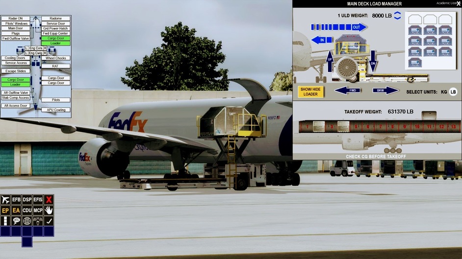


Yes folks, Chipwich Air Freight chartered a whole FedEx B777F for the mission. Sadly, we couldn’t convince FedEx to let us bring the BUFF into our paint shop (actually I gave up after a couple of hours tinkering with the paint kit), but we can have it for as long as needed, provided that we return her unharmed. And they (Captain Sim) did gave us some very cool tools for the journey, including a nifty Android app that mirrors the CDU. We found this extremely useful when taking trips to the galley or head during leg 1 (report later today).

With McMurdo Station as our final destination, we chose a W/SW route that will bring us to places never visited (Honolulu, New Zealand, and McMurdo) and allow us to return to some of our favorite vacation spots (Fiji) . Along the way, we hope to get reacquainted with old friends (a pet bat).
The big picture…
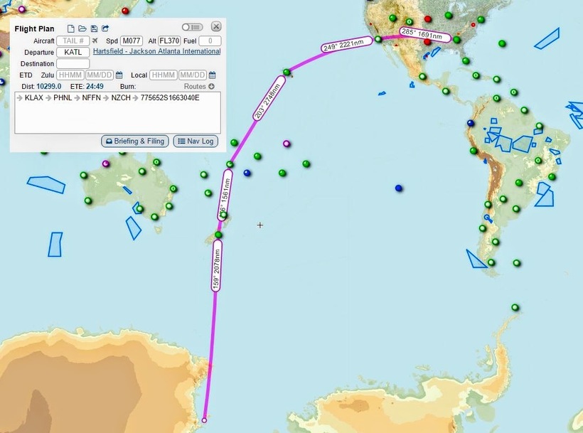
…and as a single flight plan to give an idea of leg lengths and headings.
4 Likes
Whoop! You are gonna be a big hit carrying that much egg nog and gifts!
1 Like
Maybe next year we should deliver Christmas trees…!
3 Likes
BTW @near_blind Tomcats in formation is a really hard act to follow.
Leg 01 is KTAL - KLAX. I used flightaware.com to pull up a sample leg in similar equipment, then simbrief.com to generate a flight plan. The RL and the one generated by simbrief were very similar, using the same SID and STAR, so I downloaded the flightplan in FSX/P3D format to load in the FMC as a company route. It has been quite a while since I used a CDU/FMC/MCP, but I remembered enough to init the aircraft and load the flight plan. I hoped that the rest would either come back en route, or worst case, I’d have time to read a manual.
The flight plan had already calculated the fuel, but I decided to take a bit more in case their was a fleshware problem in the mix. ATL WX was reporting 1200 over and looked it. When I asked a VFR departure to the west, I was surprised when the controller did so gladly, as if that was an every day occurrence for BUFFs leaving Hartsfield.
We taxied out waving goodbye to the big D and headed for 26R. Our route:
KATL CUTTN2 HANKO GAD MEM PNH J6 TCC ACH ABQ J78 DRK J231 TNP SEAVU2 KLAX @ FL340


Once cleared for takeoff, I knew that I was supposed to push the magic T/O button and off we’d roar into the wild blue yonder. But not having a lot of confidence in my CDU programming skills yet. I decided to firewall the sucker and ask for forgiveness later. Take it out of my paycheck.

Sure enough we went into the fluffy stuff about the time we crossed I85, but it didn’t take long to break out into a broken and scattered mix that by Alabama was mostly a memory. A trip of ten thousand miles begins but with one rotation ![]()

Ripping through the sky as if shot out of a rifle, the big Boeing makes hauling a bunch of christmas gifts, scientific supplies, vehicle and aircraft parts, and liquor for the good folks of McMurdo Station ten thousand NM distant look easy.


Seeing MEM coming up on the legs page, I get impatient to see not only FedEx’s home port, but also the mighty Mississippi. Not a bad view from FL 340.

Y’all look mighty good down there - see ya!

BTW, when big beautiful babe leveled off at 5000 per the altitude window on the MCP, my victory was short-lived. I could not figure out how to engage VNAV, so we gave up, dialed in FL 340, mach .834, and pressed on. An hour later I started looking at the SID and Legs pages. All looked good on climb out, so was an operator error for sure. VNAV was right on and putting a nasty quartering head wind in its place.
Pressing buttons to find out what happens. We have time. The coffee was typical airline fair. Drinkable but nothing to write home about. I decided to double-bag the next pot.

Back to the CDU. Cruising along somewhere over somewhere, P3D paused. OK, I think that I remember a setting that will pause the sim at TOD. Pretty cool. Had I gotten further distracted, I might have not noticed that all of the waypoints, including our STAR and KLAX were showing FL340 on the Legs pages. So, I edited SEAVU2 STAR to the entry altitude of FL160 and bang, the FMC recalculated the rest. VNAV did engage on the decent so maybe it’s beginning to return.
A little later, not knowing how to program and engage an ILS, I decided to hand fly the approach. So I set the MCP altitude window for 4K and began looking for KLAX when we are about 10 miles out. It was easy to pick up even through the smog. Remembering that flaps 25 was a good for about 165 kts at our weight, I disco’d the AP and let the fun begin.

We were a bit longer than I would like, but the first landing wasn’t too shabby for an old rusty chipwich.

What happens in LA, stays in LA. Comment: the default scenery is beginning to look pretty lame and you can’t dress it up with traffic and auto-gen around a populated place like LA due in large part to the 32 bit architecture. Catch22.

SoCal drivers!

I’d head to the barn if I knew where the barn was. The KLAX AD wasn’t a lot of help. Need to park this puppy so that I can head down to my buddy’s place in Manhattan Beach. He says that we’re are going to grab some Baja Cajan rolls for lunch and go surfing. Well, he surfs. I flounder.

Our flight time was 4:26. A DAL B772 this morning blocked 4:37, so given ~ a 20 minute taxi for him, we were pretty close. Going to check out LA for a couple of days, then head on to Honolulu.
4 Likes
Myself and GIBBO watch as Klarsnow’s burner cans disappear into the evening haze. After a short while Gibbo suggests we avoid Ecuadoran airspace on the way back, just to be safe. I reply that I’ve seen enough to last me a life time if it comes to that, I’d just as soon not return.

While we chat, the weather over the Andes has worsened. Haze has thickened, as have the clouds as moist air tries mightily to lift itself over the massive impediment in its way. In the back of my head I hear my father’s wise words about avoiding clouds with rocks in them, so just to be sure I raise the altitude another eight thousand feet. As we do, it’s time to begin our search for the tanker.

I hear Gibbs squeal with delight as he fires off the massive AWG-9. True to it’s reputation as being the biggest gorram dish in the sky, it quickly begins returning contacts. Our tanker is the one at 24,000 heading the same way we are.

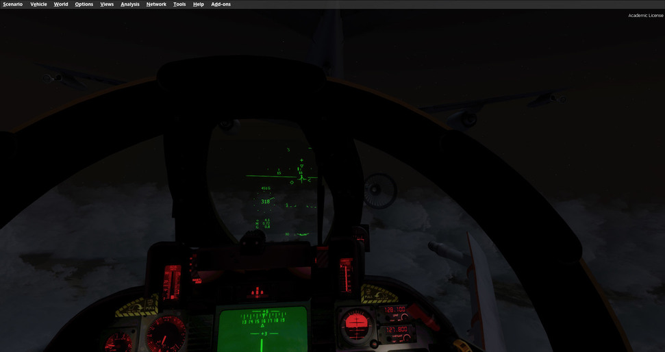
As we approach, the Gibber puts the radar into STT, probably giving the boom operator and everyone within 100 miles cancer. Sorry, not sorry. Just for extra awesomeness, I tell my Gibbo to flip the TCS into NAR FOV.

enhance

A silhouette slowly emerges from the murky green darkness…

Tally ho! ID’d as gas station.

Making nice with Tanker bro. I tell my crestfallen RIO he needs to shut down the radar, lest a stray photon ignite the gas and blow us all up. He begrudgingly agrees.

And it’s about here I realize we’ve made a terrible mistake. That weather I was talking about? Air rushing up? It did not occur to me until I tried to plug into a flailing garden hose at night that if I’m in that turbulent air, it makes air to air refueling very turbulent. Not helping things are the fact my Tomcat is very light, and it’s dark outside.
almost

After many tries, snickering from the boom operator (get back to me in 20 years dude, see whose laughing), and ample frustration we get the required gas, and settle on the tankers wing for the remaining flight into Lima. Well acquainted after a week of debauch, myself and the tanker driver trade small talk. He asks if I dealt with the goat in our hotel room, I assure him I did (I did not). We trade “fishing” stories from the beach, much to the chagrin of the female co-pilot. I’m pretty sure Gibbo’s got a thing for her, so I let him get as much broadcast time as he pleases.
After the stress of tanking, it’s a sedate night flight south. The F-14’s cockpit provides great visibility, and I can’t help but feel I’ve got the best seat in the world as I watch clouds and mountains slide past on either side, all presided over by an audience of brilliant stars.


Also that’s a big ol’ mountain.
All things must end though, sooner than expected we’re flying over the Peruvian capital. Since my jet has the least gas, and is less likely to level three city blocks if it crashes, I’m given clearance to land first and get out of the way. The tower warns me of turbulence, and I make note as I break away from the tanker.


Cutting north back towards SPJC between the cloud layers. I can feel the turbulence starting to pick up as I descend.

Tower gives me vectors for a right hand traffic pattern as I pass over Lima at night. The turbulence is rapidly becoming a factor

The turbulence is a factor. As I line up for final I’m thrown up and down as I pass through the thermals. My airspeed jumps and crashes by 20 knots at a time, completely negating my AOA indexer. I see I’m low, but this is rapidly going from an instrument to a Kentucky windage landing.

A gust of wind knocks me to the right short of touch down, and I’m descending faster than I like, but I’m committed.
Touchdown was rough, but nothing seems broken, and the jet taxi’s fine. SPJC hands me off to ground, and I radio a warning to the tanker as I taxi for parking.
We pop the canopy as the engines wind down, and let the cool-ish night air wash over us. Another leg of our trip is complete, and I need a drink. I’m sad to have completed what will probably be the most exciting portion of the trip as well. The next few days entail marathon over water flights, with nothing but Gibbo and the tanker crew to keep company.
10 Likes
Bravo…! Man…you all are making great progress!
1 Like