727-100 with CIVA INS and using modern SIDs / STARs

Continuing the discussion from Official 6th Annual Mudspike Christmas Flight 2020 - Discussion & AAR Thread as rightly recommended by @Freak :

I have a question regarding flight planning for my 727.

The CIVA INS allows me to put in 9 lat/long coordinates.

This is fine for the en route fixes and waypoints, because Skyvector gives me coordinates for the INS.

It doesn’t appear to work very well for departures and arrivals, though, as it seems Australia’s SID and STAR procedure charts are all GNSS PBN based (I think - https://www.airservicesaustralia.com/aip/current/sup/a18-h05.pdf) and don’t actually state coordinates for me to enter to the INS.

So in practice, does this effectively limit me to using radar vector departures and just imagine that I have been vectored to my first en route fix and go with the INS from there?

As far as I can see, I can’t find the coordinates for the RNAV waypoints anywhere, so while I could manually enter all of those waypoints in the INS in theory, I don’t have right information for it.

Sorry if my question doesn’t make sense, I’m very new to this IFR stuff.

Here’s an example - I’m currently in Darwin, wanting to make my way to Bali. The Darwin Julie Five departure seems to take me to the right place (JULIE) from which I can follow the airways. Assume a takeoff from RWY 29, I am to fly runway heading 286 for 11 NM to NASUX, cross NASUX at or above 4000 ft, then track 303 for 13 NM to SADAR and 295 for 55 to JULIE.

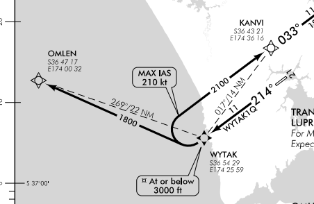
However, unlike with the NZWP SID chart below, the waypoints don’t have coordinates on the chart:

image

I assume this is because in Australia the standard is that you need a more modern navigation system than what I have onboard. So - do I just have to use the radar departure and would basically get given vectors to get to JULIE? (track 286 until at 2000ft, then turn to assigned heading)

I hope this isn’t an annoying question, as obviously you can’t teach someone everything about the topic in a nutshell…but I’m trying to do this Xmas trek at least with a nod of sorts towards the procedures and just taking off and landing randomly seems a bit flippant! :smiley:

1 Like

I know nothing about CIVA INS but yor assumptions sounds correct to my ears :slight_smile:

I quickly asked google and he answered with some obsolete chart from 2003 which can be of some use to hopefully clarify some of your questions

FSCharts.com - DARWIN EAST DEP ALL RWYS

FSCharts.com - DARWIN EAST DEP ALL RWYS PG2

1 Like

Maybe @TheAlmightySnark knows? He knows a lot about the system so maybe he also knows the workarounds for these limitations.

2 Likes

I am by no means an expert in this, but I believe that you should be able to find the exact position of such waypoints, even if they are not in your nav database.

In the end, GPS also works with lat/lon positions, these charts just assume that those coordinates are in your device’s nav database.

I was able to find these charts for Darwin with coordinates: https://www.google.com/url?q=https://www.crc.id.au/xplane/charts/DAPS-2020-MAY-21/Darwin%2520(YPDN).pdf&sa=U&ved=2ahUKEwja_ZaM28HtAhUB_aQKHfzDAbUQFjAEegQICRAB&usg=AOvVaw3BNM7ElgvCe7VsdjqawHva

I was trying to find your charts but happened upon these.

Still not sure what the general way is to find these positions. I think that they can also be defines differently thanby lat/lon, i.e. as VOR radial cross sections. Not sure if you’ll still see that, and where to find it.

1 Like

Huh, that’s handy, thank you!

Looks like somewhere between 2017 and now they’ve removed the lat/long references from the charts. I’ve been using Australia’s AIP database for the charts:

It’s quite similar to what’s publicly available in NZ - basically all the aerodrome charts, SIDs and STARs, noise abatement, aprons and soforth.

1 Like

So what we’re looking for in that case is a human-readable nav database. I wonder if some of the professionals would know about this @BeachAV8R @PaulRix ?

Isn’t the AIRAC file just a human readable text file?

You could plot the SID as a flightplan and load that into the CIVA, but that is the “cheat” method, you don’t have to manually punch in the coordinates.

The CIVA is still from a age where SID/STAR’s didn’t exist in it’s current form so alas, it is one of the limitations when operating older equipment.

2 Likes

One way you could do it would be to throw the route into Simbrief or Skyvector.

With Skyvector, hit “Navlog” and it’ll show you the lat/long for all the points. Simbrief will have it on the briefing printout.

3 Likes

I use the CIVA INS for the Concorde in Xplane and fly non-RNAV SIDs and STARs. I have a Navigraph subscription that has current data. IMO the best overall flight sim/nav integration. Real life pilot apps like JeppFD and Foreflight also provide that information.

So in practical terms, when I fly the Concorde on VATSIM, I always file “non-RNAV SID/STARs only or Radar Vectors” (along with an non-RNAV equipment code) as a prompt to the controller should they change my filed route.
Every once in a while, a controller (likely out of habit) will instruct “Concorde xxx, cleared direct XXXXX (waypoint)”. Yeah give me about 1 minute to input and verify the lat/long. :slight_smile:

1 Like

Thanks guys! That’s really helpful.

It looks like a good solution is using Simbrief, as that gives you a handy “printout” of the flightplan with coordinates for RNAV waypoints too - and they even come in the right format, by the looks! Super handy!

Quite a lot of labour to get your complex RNAV SIDs and STARs loaded, as those will inevitably result in more than 9 waypoints for the route so you have to keep entering more waypoints en route…but it’s nice to know it is possible.

1 Like

Also note that the CIVA won’t be accurate enough anymore once you get down to the approach, especially if your route hasn’t been a straight line. Consider updating the navigational accuracy 20 or so minutes before starting your approach. This requires VOR and DME beacons with known locations.

1 Like