With all of these new maps in work, I got to thinking about the Heritage of DCS in a couple different ways. The first is the time period that was the original focus of Flanker the late 1980’s to early 1990’s primarily. The Second is the original map size for the Black Sea region. If one were to focus on these two aspects, in thinking of an ideal location to create a scenario map, you might come up with this:
I have highlighted a few of the well known Western airbases from this region, no doubt there are a lot more on both sides. Like most of us, I enjoy all eras of flight simming, but this is what I envision when I look at all the Flaming Cliffs aircraft. The Normandy map will include approximately a third of this red box, good for slow WW2 aircraft. I hope we one day will be able to populate a Cold war server with our current compliment, plus maybe a Tornado, F-111, and F-4E, and of course the F-16. What are your thoughts? -Woog
Would be a great map for historic, current and future conflict scenarios. The amount of work would be huge as well, its a very dense area for cities and such. But a great map indeed.
Having just finished Dan Hampton’s Viper Pilot, it didn’t sound like the outcome would have been good for blue force, and due to the size of the combatants facing each other, would have turned central Europe into a waste land. Glad that it didn’t happen. There are probably plenty of folks on either side of the Cold War that lost sleep over that one.
Still, having played some of Fulda Gap scenarios in Steel Beasts, I can appreciate the entertainment value of a limited digital conflict.
Didn’t look good is an understatement, Fulda Gap was more of a speedbump then any fighting force that could stop a surprise sovjet attack. A few years ago whilst reading up on the Wargame: European Esacalation scenario I came across a military analyst that attempted to convince his generals that the sovjets would swing north and not do much at all at the Fulda Gap. When the documents became public years later it turned out he was correct.
Trying to find that discussion now since it was damn interesting.
1980s Central Europe is my most favourite scenario. But I think your map is way too big for any realistic chance of realisation. It contains urban area for around 200 Mio of inhabitants and probably 100 major airbases and airports. Performace issues aside, it would be a monumental task to build.
First I would cut the UK. Gameplay wise it only affects F-111 operations (and most F-111 targets in Poland are not on the map anyway). If we limit ourselves to lets say the first 2 weeks of fighting in Germany, no tactical aircraft fighting over the continent would be based in the UK as long as German bases are available as Forward Operating Bases.
Second I would cut France. Even if French units are involved (which was probable but not certain), France would do the fighting in Germany. For the sake of simplicity I would also consider to cut the Netherlands and Belgium. This only affects the Belgian and Dutch air force, as except for a single F-15 squadron, no USAF combat units were permanently based in these countries. Limiting the map to the western border of West Germany would still include roughly 20 major NATO air bases.
I would even go as far as cutting the map horizontally into two seperate projects, one featuring the operations of the 2nd Allied Tactical Air Force in the north and the other the 4 ATAF in the center and south.
While interesting (my house would be on the map. ) I tend to agree that it is basically impossible if the quality is better than FSX.
There is a VFR Germany addon for FSX (I only have one of the four parts, for south Germany) that makes the terrain halfway decent (if you squint really hard), but still FAR away from a quality that most people would call acceptable for DCSW.
With all of those addons installed you have ~60GB on your hard disk, and it looks REALLY ugly near the borders because you can see the border very well, breaking immersion completely.
For a halfway decent Germany map + a bit of buffer near the borders you would need parts of France, Poland, Czech Republic, Switzerland, Denmark, Luxembourg, Belgium, Netherlands and Austria.
All those countries with the exception of the Czech Republic and Poland are densely populated (at least in the areas that would be on the map), and Germany alone has around 82 million people.
Comparison to impress/shock non-Europeans: The USA is 30 times bigger, but has only four times the population. Germany is half the size of Texas with almost four times the population.
So basically there are cities, towns, and villages everywhere. There are four cities with more than a million people, and nine with more than half a million.
That makes central Europe very hard to model so it looks believable. Until now every game has failed miserably trying that, FSX with a sh**load of terrain addons actually getting closest, but not close enough.
So yeah, a nice dream, but I doubt it will happen.
ORBX does a good job I suppose. Although if you would want to model this it’s probably a good idea to focus on auto-generation based on a OSM like model of data.
That would also be my approach.
And maybe you would have to stream the terrain data, because it may not fit on your HD. That requires a fast Internet connection though, which would be a problem for some (including me). A big buffer space could solve that problem maybe.
…although it might work fine with a local file if you can store it compressed and read it from there.
In my company we host a OSM map server with a reduced world file (Europe only, approximately 180GB of data IIRC). The world file is around 650GB right now, but “only” 50GB when compressed.
And then you would have an additional file for all the special objects OSM doesn’t have.
Maybe that future is closer than it seems.
If we only could get our hands on those ED terrain tools… I have studied Cartography and Geoinformatics, I know how to crunch through that data.
A more realistic target might be an actual Fulda Gap map. Stretching from Sembach Air Base to about Erfurt in East Germany, including Frankfurt and the Fulda border area. Map diameter about 300km. This map would be specifically tailored to NATO anti-tank operations with the A-10A and helicopters. Due to airbase placements it would be unsuitable for air-air and Warsaw Pact flying though (all Soviet/East German air bases are in the eastern half of the GDR, a good deal away). But I would be quite supportive of approaching the problem with a well defined, narrow-scope scenario first and then expanding later on.
Sounds good, but I fear that the map borders would be a big issue. With the mountains and the sea and the desert in the existing maps you can hide those quite well, not sure if that would work in Germany.
I don’t really know if this is relevant but the maps in War Thunder ain’t really that big- they fake it with some sort of LOD… details that decrease with every belt of, oh dunno, 50-100 km terrain wide.
I think it could work, would make hugging the borders less jarring.
Do I make some sense?
Yes, this is the streaming tech that was talked about, which LOD is definitely part off.
Honestly, it would require some serious effort on ED’ part to get it working, and at that point in time and effort you might as well attempt to got for the civilian market too.
WWII Online did a pretty good job of scaling a map that stretched from SE England to about the Black Forest if memory serves. Anyway, I remember launching many missions from RAF bases and ending up over Bastogne or some other besieged city in Eastern Belgium or Holland. I don’t remember what the scale was exactly, maybe 50%, but it nicely created the illusion of distance while not killing game play.
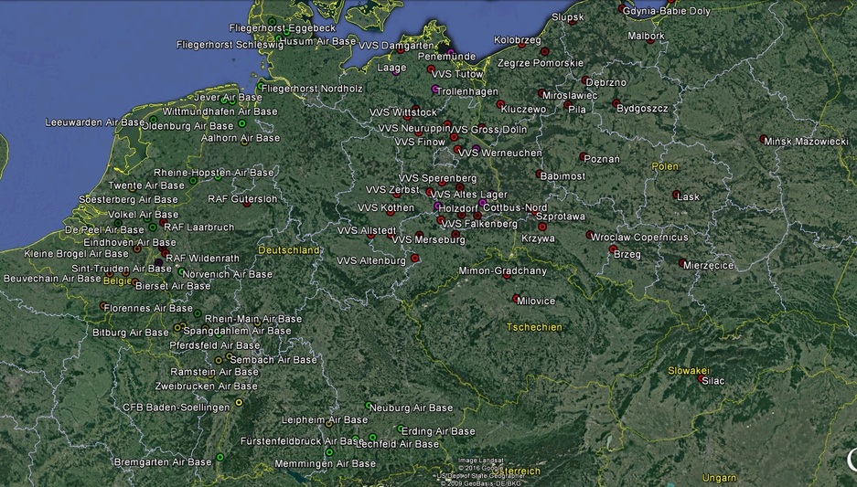
Just for giggles, here is a 1980s overview of all air bases in West Germany, East Germany, Poland, Belgium and the Netherlands with permanently deployed combat aviation units:
Not pictured are the mobile system assigned to the air defense of the ground forces. For the East German Army and the Group of Soviet Forces in Germany, these include the following additional number of firing batteries:
SA-4: 36
SA-6: 78
SA-8: 75 (4 independent launching vehicles per battery)
SA-10: 2
SA-11: 20
SA-12: 12
In addition there there would be the inherent air defense of the following armies passing through Germany: Polish Army, Soviet Northern Group of Forces (Poland), Czechoslovak Army, Soviet Central Group of Forces (CSSR), Soviet second strategic echelon (Belarus/Ukraine), Soviet 3rd strategic echelon (Russia).
Very interesting to see exactly how built up the Stand off had become by the end of the Cold War! Well I have seen some very good ideas placed forth. Judging by ED’s map building style, you could bet that only 1/10th of the airfields would actually make it into a map like this. Maybe that is a better approach? As it has been stated that the technology to drop new airbases, and scenery addon’s into an existing map is coming in a near future update, we could add detail to our hearts content. I personally, have no problem with dedicating a 1TB external drive to DCS. Of course, processing that much data efficiently is the (previously stated) key. If FSX can be used as a judge, decent Airbases would potentially measure 500mb up to 1gig each depending on the size. Large Cities 2-3 gigs each. The ORBX method of Landclass scenery probably would be the best route here. Photoreal is nice, but really is best saved for sparsely populated desert terrain.
I’m missing RAF('53)/NATO('80) Geilenkirchen on that map
I am personaly biased, but I would like to see the Netherlands and Belgium included. the RNLAF had 212 F-16’s and 30 apaches, and the BAF had atleast 72 F-16’s. So still quite a reasonable force. It might be cool if we could recreate some exercises like Frisian Flag, the last one (2016) had 65 participating combat aircraft. There’s also some strategic targets present, like AFCENT. While I’d love to have a map like that in DCS it’s probably to large to recreate, even if large parts would low quality, something I wouldn’t mind.