EPOCH Alaska Diary

Cool - I wonder if I can populate the airport with relatively low poly airplane models to give it a lived in look. I need to explore some of those utilities like X-Traffic or whatever as well. I sure would like to liven up my X-Plane world a bit…

BeachAV8R

You should be able too. X Scenery, I think thats what its called, gives you a bunch of stuff to place at airports in the WED program. Tons of aircraft ranging from 172s to 777s. I fly x plane without traffic so basically i just have static A/C on the ground. I hate the traffic system in X plane.

Man, that’s impressive!

Can you VATSIM on Xplane? Is there an equivalent? [runs to go google]

[edit: sweet! you can! http://www.vatsim.net/pilots/software re: xSquawkBox]

Is it bad I spent some time looking for bears on those Alaska weathercams! I think this site has spoiled me :slight_smile:

1 Like

Isn’t that a cool resource? I love how the FAA in Alaska thinks outside the box and actually does stuff like that. I think they are a bit more of the frontier style of enforcement too… I think I need to move to Alaska… :smiley:

BeachAV8R

After a nearly 7-hour flight yesterday, I spent the night in the EPOCH crash pad in Anchorage (PANC) before making my way back to the airport to hop another flight to the EPOCH main hub in Bethel (PABE). As luck would have it - a FlyJSims Boeing 737-200 in Alaska Air Cargo livery (by MB Liveries) was available for me to hop over to Bethel in. I can’t say enough good things about this B732 - it is an incredible aircraft for X-Plane with old school avionics and new school cockpit modeling. It is simply gorgeous and a joy to fly…

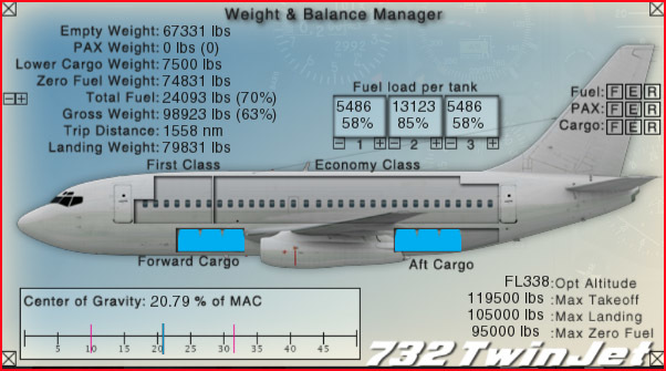
We carry a good load of cargo, no passengers, and enough fuel to make the trip to Bethel and back easily…

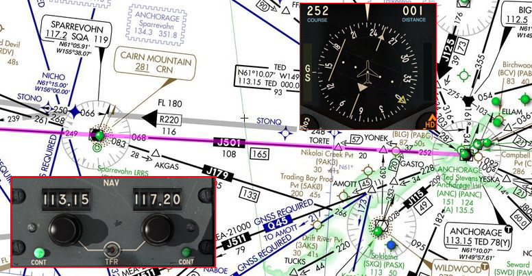
Our route will leave Anchorage (PANC) and pick up J501 off TED VOR, cross Sparrevohn VOR (SQA) enroute, then continue down J501 to Bethel VOR (BET). Since the 737-200 features old school avionics, we’ll be flying the route entirely with “green needles” on the Jet airways using our VOR radios.

After getting our engines up and running I start setting up the radios. We tune in 113.15 (TED) and set the J501 radial of 252 degrees. I also put the next VOR freq. in the standby (117.2 - SQA). Remember - the more work you do while sitting on the ramp and in dead moments of time, the less scrambling you will be doing later when it counts!

The FlyJSims 737-200 cockpit is a work of (functional) art…!

We taxi out to depart runway 15 since it is adjacent to the air cargo ramp. Our TOLD card shows our V-speeds and engine power setting (EPR) for our takeoff weight…

Throttles forward to the EPR setting and the virtual first officer calls out V1, VR, and V2… Off we go!

Aerosoft’s PANC does look great, despite the lack of static aircraft (I’m gonna fix that though!)…

Default X-Plane clouds and weather are quite good. I’m using real weather downloaded from current METARS and TAFS for my flying in Alaska to keep the challenge realistic…

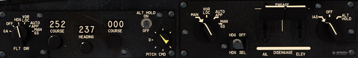
The 737-200 flight director and autopilot panel is a joy to use. Simple, straight-forward, and allows for great control of the aircraft in all modes…

We hold 250 knots using the IAS hold (not an auto-throttle though…so remember it will pitch to maintain your commanded setting!) until breaking through 10K, then we accelerate up to 300 knots during the climb. Meanwhile we fly a heading to intercept J501…

Joining J501 in the climb away from Anchorage International…

Our initial climb and route takes us out over Cook Inlet as we climb through multiple cloud layers…

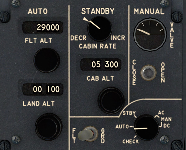
I set the pressurization controller to FL290 - our cruise altitude will be FL280 going westbound and set the cabin altitude to the recommended differential level for that altitude…

Through FL180 we go to 29.92" and our speed is settled on 300 knots as we climb toward our cruise of altitude of FL280. The altitude preselect is armed and we’ve captured our VOR course…

Through breaks in the clouds we see some spectacular scenery enroute… Soon, I’ll be winging my way VFR among some of those peaks! (If the interview goes alright!)

At FL280 I let the plane accelerate to Mach .78 then pull the power back to maintain that speed…

A really nice flight deck on this 737-200…

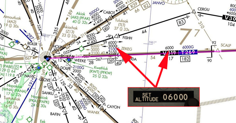
Again, being unfamiliar with the terrain I’m flying over, and not under ATC control, I elect to play conservatively. “Stay on the black lines on the chart, and you won’t run into anything…” said my CFI many, many years ago. So I check out the low enroute and see that the mileage break between SQA and BET occurs at around 92 miles. The MEA is 6000 until VIDDA intersection when it drops down to 3000 westbound. Thus, I start my descent at idle power over SQA VOR and settle at 6,000’ waiting for 40DME from Bethel…

At the mileage break, I switch to Bethel VOR and put the ILS 19R localizer frequency in the standby…

With multiple broken layers and the METAR reporting weather around the initial ILS approach altitude, I decide to stay on the “black lines” and shoot the full approach into Bethel…

At 40 miles, the enroute chart indicates I can descend further to 3,000’. I hit IAS hold and pull the power to idle to allow the nose to drop until we capture 3,000’…

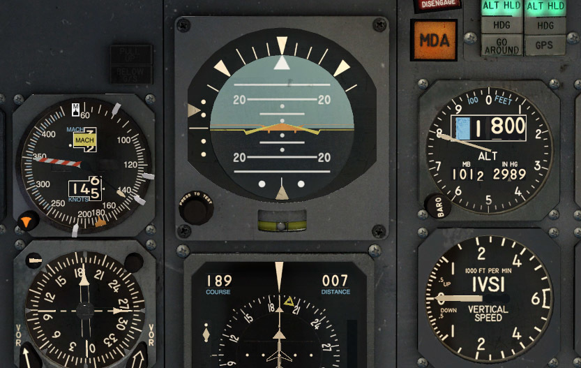
Once we capture 3,000’, I set my heading bug to a right 90 degree turn in anticipation of starting the DME ARC to the ILS. I also set 1,800’ in the preselect but don’t disengage altitude hold yet. Now all I have to do is wait until a few miles from the ARC and hit HDG mode and IAS hold and pull the throttle to idle and the airplane will automagically turn and descend onto the arc…

Commencing the ILS DME Z RWY 19R. The reason I have to fly the ARC is that the ILS DME Y uses RNAV waypoints to establish on the ILS inbound course - something my -200 does not possess. That’s OK though, flying a DME ARC with an HSI and an RMI is a piece of cake…

We maintain a distance of 12 DME as we arc, keep the airspeed around 170 and start getting the aircraft dirty while we drop to the 1,800’ ARC altitude. Just keep the RMI needle off the wing and adjust your angles to widen or shallow the arc as necessary…

A few minutes later we’ve slowed to 145 and the 199 lead radial is indicating that we need to go ahead and turn inbound and switch frequencies to the ILS while monitoring the VOR course on the RMI (or the first officer HSI)…

As we make the turn, the ILS course comes alive. A sharp eyed reader will see a mistake here (that I catch about 30 second later)…

LOC captured, Glideslope armed and speed looks good…

At the initial approach altitude we are skimming through the bottom of the murk…

One dot below the glideslope…getting ready to capture…time to swing the gear…

We have the radar altimeter set to 200’ minimums and just prior we disengage the autopilot and hand fly the last few hundred feet…

With 6,400’ of runway, Bethel has plenty of room for the 737-200…

Spoilers, thrust reversers, and only minimal braking are required…

Pulling off the runway we clean up the aircraft and taxi to the ramp…

Elapsed time is 1+05 and we’ve only burned about 2300 lbs. of fuel…

Here we are! The green building is EPOCH’s operations building - wish me luck! (Beautiful EPOCH Bethel scenery available to registered users: HERE!)

BeachAV8R

2 Likes

So what was the mistake? Guess I’m not sharp eyed. I’m not familiar with civilian jets. Do you use manual controls besides take off and landing?

Pretty interesting.

Well, the mistake was minor - and actually doesn’t affect the outcome even if I had not caught it. But when I set the inbound course on the HSI for the ILS - I was off by 10 degrees. You can see the difference (199 vs 189) in these two shots…

The good news is - the ILS inbound course is for reference only and it doesn’t actually matter what you put in the HSI because the airplane is only tracking a single beam and twisting the OBS does not change that frequency like it does when you are selecting a VOR station. It was just a small mistake, but when you brief the ILS several times, you should put the right inbound course in the HSI…

BeachAV8R

1 Like

Good news - I got the job! I guess the three days of stubble from lack of a shave didn’t count against me…! So the highlights:

1 - I’ll be based at King Ranch (AK59), one of EPOCHs specialty hubs for SAR training and other needs.

https://img.airnav.com/ap/29300.jpg?v=KMS96V

2 - I’ll fly occasional flights out of Valdez (PAVD) for revenue.

3 - I’ve got a house and hangar being built at Beaver Creek Air Park (CYXQ) - an EPOCH community!

4 - My personal aircraft is going to be the awesome Shade Tree Micro Aviation (STMA) PC-12 - probably a little rich for a lowly bush pilot, but this job is more about pursuing a lifelong dream than making a mint!

According to EPOCH management, my PC-12 will be available for pickup tomorrow (now today) at 0800 at Merrill field (PAMR) in Anchorage. It is scheduled to go into paint this evening…! Fortunately, I’ve managed to secure a ride back over to Anchorage from Bethel with a transient Canadian SAR aircraft. When they heard I might be based at King Ranch, they were more than happy to drop me off at PAMR.

We check the weather over at Merrill and they are indicating a few broken layers. Our Alenia C-27J (by Paolo) is not a true RNAV approach certified aircraft, so we’ll have to use a trick of the trade and file IFR to Anchorage International (PANC), shoot the approach there, then proceed VFR under the clouds to Merrill just a short distance beyond PANC. With a solid plan, we pour the power to it and get out of Bethel…

We are flying V319 eastbound over Sparrevohn VOR and then on to Anchorage, so I set up the HSI and NAV radios for that course…

The C-27J is a fantastic short field performer. We climb out of Bethel and turn eastbound, climbing initially up to 7,000’…

Sometimes part of SAR is just showing the flag…

As we head east the cloud cover gets a bit heavier toward the mid-point of the route…

As we approach Sparrevohn, we initial a climb to a higher altitude, necessitating turning on anti-ice measures as we get into some clouds…

We settle at 13,000’ for the flight past Sparrevohn due to the eastbound MEA on V319 of 12,000’. You could fly lower on the T-route but the 12,000 MEA assures both terrain clearance and navigation signal reliability.

Why such a high MEA? - THIS! Always pay attention to your charts (particularly in an area like Alaska with such widely varying terrain…)

We maintain 13,000 on V319 until we are 57 DME from TED VOR, at which point the MEA drops to 7,000 eastbound. The plan is to use the GPS to fly direct to AINKK waypoint, which is on the final approach course for the ILS 7L at Anchorage.

After shooting the ILS to 7L at PANC we plan to break out high enough to proceed VFR to Merrill Field…

At AINKK we swap back to green needles and pick up the ILS inbound to PANC…

As expected, the ceiling is high enough that we break out way early. We cancel our IFR approach and request VFR direct to Merrill…

As we approach Merrill, the Spartan drivers indicate we will land on runway 5 - a bit of a surprise to me. They want to show off the awesome short field capabilities of the C-27J and shoehorn it into the 2,000’ gravel strip…

I switch to the HUD view for the landing. Full flaps and we drag it in at around 95 knots…

PAMR by -bc- is absolutely stunning…

We aim for the very beginning of the gravel strip and keep speed right at minimum controllable…

Touchdown is firm and with very little flare - just get it on the ground and save the finesse for longer runways!

Full reverse and braking brings us to a stop in just about 1,600 - plenty of room!

Fortunately the taxiways are just wide enough to accommodate the Spartan as we taxi to the Quebec transient parking area…

As stated, the airport is really nicely populated if your system can handle it…!

We round the corner and I spot my plane! The PC-12 is parked just off the transient area and is getting ready to get towed in for the repaint… Awesome!

My Candian hosts wish me luck with my new job and kindly feather the left prop to allow me to disembark (I could have gone down the tail ramp actually…)

I head down the stairs - eyes on my dream plane…

The Spartan heads back to runway 5 to demonstrate a short field takeoff and moments later they are winging their way eastbound toward their home base…

Many thanks for the ride fellas. Now I just have to wait for my Pilatus to get finished in paint and we’ll start the next phase of the journey… Thanks to -bc- and the other EPOCH pilots for the warm welcome and all the tips, suggestions, and guidance…

BeachAV8R

1 Like

Good morning! As promised, my PC-12 is out of the paint shop and ready to go. She looks gorgeous sitting at the transient ramp at Merrill Field…

Of course, after a repaint you should tear the plane apart on the preflight inspection. Having picked up planes from paint many times before, you have to check everything. Look for taped over ports, misrigged controls (particularly trim!), unsecured panels, and left over parts or tools. It isn’t unusual to read about planes coming out of the paint shop and running into problems on the first flight after…

The cold and dark Shade Tree Micro Aviation (STMA) PC-12. Time to go through the start procedure…

The panel is nice and includes some lightly modeled Garmin 530s, which is a relatively new addition to the STMA PC-12 - and a welcomed upgrade!

I plug in direct to Silver City (CFQ5) in the Yukon - my destination this morning. We will be flying IFR RNAV direct at FL230 to make sure we clear the very high terrain between us here in Anchorage and Silver City. Flight time should be around 1+24

Double check the trim tabs and control movements…

We taxi out to the 4,000’ long runway 7 at Merrill Field…

I take a look at the nearest weather reporting facility to Silver City (Burwash) and the weather looks like it is holding up, but I’m concerned about the multiple cloud layers and the forecast isn’t very good. There are no instrument approaches to Silver City, so weather is of prime concern…

Again, I can’t say enough good things about the Merrill Field scenery…

On the roll…

Positive rate…gear up…

Liftoff time is around 1000(L) and our tanks are full…

It doesn’t take long for the terrain to ramp up as we cross the first set of mountains east of Anchorage (Chugach I think?)…

I engage 150 knots airspeed hold and climb up to FL230 where we level off for the cruise. The PC12 sips gas burning just shy of 400 lbs./hour. I pull the power back to about 740 ITT to save a bit…

The wide expanse of wilderness in Alaska and Canada is just mind boggling…

The clouds remain a concern as I keep an eye on our destination reports…

Default X-Plane cloud layers are very well done. I’m surprised to see it even seems to do rising cloud decks of some sort…really nice (if only their performance was a bit better!)…

As we approach Silver City, we have to stay really high due to the terrain west of the field. It leaves you looking at a bit of a slam dunk approach to go from the 20s down to a few thousand feet…

About 30 miles out I start a descent to 5,000 my hitting IAS hold and closing the throttle. As the clouds close in, I have second thoughts about that altitude and consult the local IFR chart to determine a safe MEA and settle on 11,000 to be safe…

As I get over top of Silver City airport the cloud decks are solid below. I know what is coming - ATC is going to want to know what the plan is. I’m trying to fly this EPOCH adventure according to real conditions and real rules (for the most part), so I know I can’t just go busting down through the clouds. I scramble and come up with the plan of proceeding up to Burwash on the airway to maintain terrain clearance. Meanwhile, I pull the power back to slow to 150 knots since I’m not in a hurry to fly away from the airport…

A look at the VFR map shows why stopping at 11,000 was a good idea - take a look at the terrain just west of the airport. And updated wx report for Burwash shows multiple scattered and broken layers. X-Plane just reads the current METAR and builds clouds and weather based on that, so I’m at the mercy of the real conditions and however X-Plane wants to interpret them…

As I fly slowly north there are some tantalizing holes in the clouds that are too small and close up too fast to take advantage of. Again, I could be illegal and just bump my nose over and descend through the clouds, but the rules are the rules…

Finally, after flying nearly up to Burwash, I start getting some nice size holes in the undercast and I quickly cancel IFR, disengage the autopilot, and swoop down through one of them. I’m confident in my position and the fact that I’m over the lake is good since there is plenty of room down there to maneuver…

The view is beautiful below the overcast and I continue the turn back around to the south and plug in direct to CFQ5 hoping the weather holds for the short sprint to Silver City…

After a few minutes, Silver City strip comes into view. I cross over and enter the right downwind to land on runway 36…

The gravel runway is cut out of the surrounding forest and is part of the Ultimate Glacier Pilot Adventure Package

Safely in Silver City! Elapsed time was about 1+33 and we used about 651 lbs. of fuel with nearly 3/4 fuel remaining. I’m happy the weather let me in or I’d have had to divert to Yakutat until conditions at Silver City came up…

BeachAV8R

3 Likes

Loving these updates, Beach! Xplane looks beautiful, and that PC-12…wow!

Question: why was it “illegal” for you to drop through the clouds? I thought that’s what IFR was all about?

It would be illegal unless a controller cleared me to drop through the clouds - and in that (presumably) non-radar environment, the controlling agency up there would not probably not offer a decent unless you were on a prescribed route that had a minimum enroute altitude (MEA) - or, if you are in radar contact, they would have a Minimum Vectoring Altitude. Minimum Vectoring Altitudes can often be lower than the Minimum Sector Altitude…for instance, when you are getting vectored for an ILS approach in mountainous terrain, the local radar approach controller has a high enough resolution radar and coverage that he can take you down below the peaks. Where I was flying, there is no approach radar facility, and the center radar does not have the coverage to separate you from terrain. Therefore, they tend to only let you fly on courses and altitudes that are accepted as having enough terrain clearance.

Even though I was extremely certain of my position over the lake, it is still illegal for me to descend through the clouds, and a controller would not authorize it even if I asked for it. This can often be a dilemma for pilots who are under radar control that only need to squeak down a couple hundred more feet to get VFR - and can sometimes lead to poor decision-making by pilots trying to sneak in through a sucker hole or just “pop through” the undercast.

As we’ve noted before EP - sim flying and real world flying are two wholly different things. We tend to do riskier things in the sim and perhaps skirt the rules a bit for the sake of fun. It can also be rewarding to fly by the rules and face the types of conditions and decisions that real pilots sometimes come across.

BeachAV8R

http://forums.mudspike.com/uploads/default/original/1X/b6a8962c1d1df620b2aa8de9095bc76cceb26048.jpg

“On Canadian IFR High- and Low-Level charts, area minimum altitudes (AMA) are published for quadrangle areas, which provide a buffer beyond the VFR maximum elevation figure. The AMA is the lowest off-airway altitude to be used under instrument meteorological conditions (IMC) that will provide a minimum vertical clearance of 1,000 feet (AGL), or in designated mountainous terrain 2,000 feet above all obstacles located in the area specified, rounded up to the nearest 100 foot increment.”

Those are the Large/Small blue numbers in each quadrangle on that chart. As you can see, just west of Silver Creek the numbers is 150 - 15,000’ due (no doubt) to the 14,261’ peak in the bottom left of that quadrangle. That is a VFR chart, not an IFR one, so my guess is the IFR one has even higher numbers to meet that +2000’ requirement (and indeed it does - 181 or 18,100’):

So technically I was illegal in those sectors flying below 21,900’ and 18,100, and 11,300 respectively moving west to east if I was off airway (which I was). So I’ll need to file the equivalent of a Canada ASRS report…LOL

BeachAV8R

I’m on it…

http://wwwapps.tc.gc.ca/saf-sec-sur/2/IR-RI/av_i_r.aspx?lang=eng

1 Like

I should post my AAR in there and see if I get a virtual suspension…LOL

The morning after flying my PC-12 over to Silver Creek from Anchorage, the day breaks bright and clear (and a small surprise in that we got a dusting of snow - sorry, was just testing my winter textures with JSGME). We also get our first look at the gorgeous Shade Tree Micro Aviation A-1A Husky sporting a pair of tundra tires and retractable skis. (Purchase the STMA Husky: HERE!). The 180hp Husky is the perfect Alaska bush plane. The STMA variants include regular wheels (with and without wheel pants), tundra wheels, skis, and floats. You can also mount a belly cargo pod for additional carrying capacity.

Our flight today is a glacier flying tutorial that is part of the Ultimate Glacier Pilot Adventure Package. We will take off from Silver City and proceed (following instructions) to the UXTG training glacier strip. I put the airport identifier in the GPS for reference…

The beauty of flying aircraft such as the Husky is that it is really basic, and all stick and rudder. Turn the fuel on, battery on, mixture rich, prime, starter…and you are ready to go!

The UGP (Ultimate Glacier Pilot) training features (of course) custom scenery and an excellent use of a cockpit script to give you pointers and instructions. This is exactly the type of stuff I think our civil side simulators need - reasons to fly and thing to do - I love it! The instructions indicate what you are supposed to do, then you cycle the script (you can map it to a button on your stick if you like) to the next instruction…

In addition to the text script, you can choose varying levels of additional aids - in this case I used the full tutorial features that paint click spots and arrows that are drawn on the terrain where you are supposed to cycle the instructions.What a great use of X-Plane’s scripting capabilities!

With a notch of flaps we head skyward with instructions to enter a left downwind, then crosswind to pick up the rest of the route…

East of the field, large arrows are drawn on the terrain to indicate our direction of travel. At each “CLICK” spot we receive further instructions…

Throughout the tutorial there are helpful tips that give some basic insights into glacier flying…

Into a mountain pass we go…

The flight through the mountains is short, and soon we have the training glacier strip in sight. It is marked up with additional aids and reference points…

The goal is to land on the green LAND as opposed to the orange or red ones…

After touching down on the skis, a bit of power is required to climb the slope to the hut at the top of the strip…

Success!

After a brief stop for some hot chocolate at the hut, we head back over to Silver City. Though the training is basic, I love the use of the cockpit checklist files to cycle through the instructions and the custom terrain markings (which can be turned on and off) are a great instructional tool. Nice job by the creators of Ultimate Glacier Pilot!

BeachAV8R

2 Likes

With our short glacier pilot training complete (this is a bit of an “on the job training” gig) it is time to take wing back west toward the Anchorage area and scope out my new EPOCH base of operations - King Ranch (AK59). For this flight I’m using a nifty online flying/tracking tool that uses a plug-in within X-Plane to broadcast your position to other players. A nice side-benefit of this is that you can also track your own progress on the server map. So those that clicked on the map below during my flight would have seen me progressing slowly across the map…

Here is the X-Plane plug-in: http://www.x-flightserver.net/beta/

The map showing who is currently online: http://xfsd.ansorg-web.de/fsdmap/

Our flight will initially take us north-northwest up to Burwash NDB in order to allow us to climb high enough to make the turn westward and clear the mountains. As we talked about previously, the minimum IFR sector altitude for off-airway navigation is a whooping 21,900’ just a few miles west of Kluane Lake, so you need to climb high fairly quickly before turning on course. After reaching Burwash NDB (DB) we will proceed direct to Gulkana VOR (GKN). Initially I set the next point as my destination AK59, but later modified the route to join V456 after passing Gulkana VOR. The MEA westbound sits at 10,000’ in that area and the route is technically defined as GKN V456 BGQ. V456 passes almost directly over AK59, so my intent is to stay on the airway (ensuring terrain clearance) until I’m confident that I can proceed VFR to the airfield to land.

With a plan set, I program the GPS (later adding BGQ after GKN) and connect to the online server (filing a flightplan as well)…

Plenty of room for the PC-12 at Silver Creek…

I’ve found that IAS hold of 150 knots works out very well for the climb to whatever altitude I’m seeking - in this case FL240…

The reason for the steep climb and the slight deviation toward Burwash is fairly evident - the terrain ramps up very quickly to the west of the line between Silver Creek and Burwash…

Reaching Burwash NDB, we turn left to head direct to Gulkana VOR at FL240…

High clouds eventually break and for a long period we have nearly clear skies…

Approaching the Mount Wrangell / Mount Sanford area the scenery is just incredible. The glaciers, peaks, and valleys appear as a post card below and stretching to all quadrants. This truly is an incredible place to fly…

16,237’ high Mount Sanford just to the north of our course…one of the many, many reasons why flying IFR (in actual IMC) has to be done carefully…

After crossing the VOR I head down to the MEA of 10,000’ and we track V456 to BGQ. As you can see, our destination (AK59) is directly under the airway…

After sixty miles of clear skies, X-Plane starts reading the weather (I’m always using real/current weather) in the approaching areas and some scattered layers start building…

About fifty miles out I get a good sense that the weather the rest of the way in is going to hold up just fine, so we cancel IFR, leave the airway and descend down into the Matanuska River valley that snakes parallel to the Glenn Highway…

The moon is just setting in the western sky…

Alaska has some unique pilots aids such as tons of strategically placed webcams that can help pilots judge local conditions. Many fields don’t have an AWOS or designated weather reporting person, but sometimes a picture tells a thousand words. Here, the Chickaloon cam shows a perfect view up the valley to the east - allowing me the piece of mind that the valley is solidly VFR…

I follow the contours of the river valley westbound and soon we are on top of King Ranch. Whoa - pretty small field (1,800’ runway length) with quite a bit of slope to it!

Here is a nice video demonstrating the “rural” feel of King Ranch…

I pass over the airfield to assess it, then arc around over the south side of the river and come around in a right turn to line up on runway 6…

About 90 knots has plenty of buffer and the PC-12 with a reversing prop can stop on a dime…

This might get interesting in the winter!

Up to the top of the hill we climb and I pull of on the southeast ramp - I’m here! Finally here! Time enroute was 1+06 and fuel burned was just shy of 500 lbs. Now I’ll poke around the airport a little bit and see what I’ve gotten myself into!

BeachAV8R

3 Likes

So today we are going to attempt our first flight for EPOCH. This was a special one-off mission that was published last year, but we are going to skim it out of the archives and take a crack at it ourselves. The mission has a very nice briefing book with multiple missions that allow for many different types of aircraft and mission profiles.

My mission is a straightforward rescue mission to the high altitude landing strip on the Denali Step…

My custom Shade Tree Micro Aviation A-1A Husky in EPOCH livery (original by RocLobster). My base is King Ranch (AK59) and it is a beautiful location…

My Husky has a zero-time engine on it and I make some back of the napkin fuel calculations and come up with filling the tanks halfway for my trip to Denali and then on to Skwentna (PASW)…

I load the essentials into the GPS and head out on my first mission…

I basically climb gradually for the first 30 minutes of the flight since I know I’ll be needing to be up around 14 to 15 thousand feet for the landing at Denali Step. Bordering the north side of the Matanuska River valley is the first bit of high terrain, then the mountains drop into the Susitna River valley near Talkeetna. I’ve entered the mission required weather and it provides a nice layering of clouds. The turbulence (even on 1) gets a bit tiresome after a half hour though since the Husky has no autopilot…

As I climb, I continuously check the status of the engine temperature by pulling the mixture back to lean it. At peak lean, I roll it in to be 50 degrees rich of peak lean…

Crossing the first bit of mountains I start to see some snow cover and glaciers…

I have my online flight tracking on so people can see my progress on the map. A few minutes later - real life invades and my pager goes off, so I set out on a real life flight while my Alaska trip gets put on pause. After skipping around to Roanoke and Philadelphia, and after some rest in the morning, I’m back in Alaska by mid next day…

The scenery is always gorgeous…

I love these Cockpit Intelligence Files that come with the Ultimate Glacier Pilot Adventure package. They basically contain the “gouge” on the airfields in the package. Apparently, I picked one of the hardest strips for my first EPOCH flight…whoops!

Approaching the Susitna River just south of Talkeetna…

Soon, the massive bulk of Denali starts to rise out of the clouds ahead. Wow…what a monster!! I maintain around 15,000’ and I have contact with another EPOCH pilot (Dirob) on the radio. He is waiting for my arrival at UX09 and it is useful that he was on the network since I could use his reported position to find the strip more easily. I go ahead and lower my skis for the snow landing…

We use the multi-player plug-in to chat as I approach from the southeast. The landing strip sits on the western flanks of the mountain…

I circle around the south side of the mountain and elect to do a flyby to assess what the strip looks like (I’ve never seen it…)

Dirob gives me a weather report and I spot his beacon and nav lights on the strip…

Satisfied with what I see - I break off and circle around to the left to join the straight in approach. It is pretty evident that this isn’t a strip where you have many options beyond the runway threshold. Going around from a close in position would probably result in a crash…

My first approach starts off OK…but I as I approach the strip I’m bending the throttle forward even as my airspeed continues to decay. I can feel that sinking feeling and know I’m behind the power curve. I was too shallow, too slow, and I would learn later - I had never advanced my prop from cruise (2000 RPM) to full forward - which would give me better bite and performance at the higher RPM (rookie mistake!). I catch the situation early enough that I’m able to safely break off the approach to the right and recover as I drop some altitude. I climb back up and set up for a second approach…

My second approach comes out nearly the same…still too shallow, too slow, and just can’t get enough oomph out of the engine. I’m dragging the approach in and I think it is because the severe uphill slope is causing a visual illusion of me being on glidepath when I’m clearly low (this is a common visual illusion with sloping runways). I elect to go around again, but still haven’t discovered the cruise RPM setting problem…

My third approach is higher, steeper, and with more reserve airspeed, and less flaps. It works out much better, despite still not having the prop forward…

I touchdown about halfway down the runway and stop within one or two cones distance. It takes full power to taxi up the steep incline to the top of the strip where I shut down and go find my passenger…I probably should have brought a coat and a thermos though (and an oxygen tank…wheeze…)

The scale of things in Alaska is just mind blowing. Here is my tiny dot of an aircraft on the Denali Step with the upper portion of the mountain looming above… Hope X-Plane doesn’t model avalanches!

It takes 1.3 of Hobbs time to reach UX09 and you can see my three approaches plotted on the network tracker…

A snapshot from the slopes high above the airfield looking down and out across to the west… Awesome!

I change the weather setting from the mission designated one to real weather - and am surprised to see the real weather is actually a touch better than the canned one. I think typically it would be much, much worse…

Time to head for Skwentna. I start up the engine - note that I have about a quarter tank of fuel in each wing remaining and point the nose down the hill…

What a thrilling departure!

Since I’m trading a lot of altitude for speed on the way down to Skwentna, my estimated time enroute is only around 25 minutes…

Don’t ask where my patient is - let’s just say I stuffed him in the belly pod…

The glacier pouring out of the mountains toward the plains…

The PASW briefing gives me the low-down on the airfield - rated 1 for Recruit!

The clouds come and go enroute…always adding some variety…

A check of the site gauges on the wing roots show the fuel is down to around 1/8th of a tank. My fuel planning was pretty good…but good thing I didn’t run into any strong headwinds!

Safely on the ground - I discharge my sick climber to the local paramedics. Mission accomplished in 2.0 hours of flying…and no bent pieces of airplane.

There are additional missions to fly within the Rescue On Denali briefing…so I’ll probably pick up a few more flights while I’m in the area… Nice job by the mission designer and, as always, great flying with and discussing the flights with the members of EPOCH Alaska Air…

Stay tuned - I made a video of this mission as well - to be posted within the next hour…!

BeachAV8R

2 Likes

Nice! This looks like a lot of fun! I love the Husky - I’m a big fan of tailwheel aircraft.

Is the Hobbs meter persistent across flights? If so, does the model keep track of life for just the engine, or other systems? Does performance degrade with wear/life? Does this feature come with Shady Tree or EPOCH? SO MANY QUESTIONS

The Hobbs meter is persistent across flights. I think that is true for the different variants too (ie: the floatplane has a different Hobbs than the ski version). I don’t think STMA has modeled persistent wear - some modules for FSX do that…but I don’t know if any X-Plane ones do that. The Hobbs thing comes with the STMA airplanes…

BeachAV8R