Frank Dainese’s Mountain Parks for X-Plane
By @smokinhole - December 9, 2019
Originally published at: Articles - Mudspike Forums

Frank Dainese and Fabio Bellini are artists. Their canvases are a growing portfolio of mountainous regions that have potential appeal to virtual pilots. They do their work meter by meter using the highest resolution elevation data that is available to them. They also avoid orthophotos preferring to place objects, trees and granite in by hand rather than dealing with the artifacts like shadows and vehicles that inevitably come with satellite imagery. The results are lovingly detailed alpine valleys and breathtakingly majestic peaks that maintain their detail right up to impact.
I am trying to avoid the “V-word” but it is not easy. A 3D world so meticulously recreated can only truly be appreciated in 3D. If you read the reviews of Dainese and Bellini’s mountain playgrounds over at helisimmer.com you begin to detect a certain frustration as new sceneries drop. How does one say something that hasn’t been said before about works that are so consistently well done? The following gets said in every review:
- The scenery is gorgeous.
- It is perfect for (and arguably made for) helicopters.
- Despite being overstuffed with objects to explore and appreciate, it runs well or at least well enough on any machine that already has the horsepower to run VR.
To avoid such frustration, I won’t presume to be able to improve on what’s already been said. What follows instead are a few screenshots and a little story to shed some light on why their work is meaningful to me.
I have two very weak spots: one for helicopters and the other for mountains. The first is an itch I am saving to scratch later in life and the second is one I scratched ever so delicately when I was younger. It is hardly a surprise that someone like me would find plenty to love with the work these two designers have shared with the flight sim world.

Dainese’s work, sometimes in concert with Bellini and sometimes alone, can be found at the X-plane.org store and at ORBX. ORBX offers his earlier projects for FSX and P3D including Yosemite and Devils Tower. They also carry his Monument Valley for X-Plane (this last with the assistance of Fabio Bellini). X-Plane.org sells what they call their 3D Mountain Parks: “3D Matterhorn Park”, “Everest Park 3D”, “Cerro Torre Los Glacieres 3D”, “3D Eiger Park”, and the latest (which kindly dispenses with the unnecessary “3D” qualifier): “Mont Blanc Group”. There is also a massive 24 GB “Dolomiti 3D” which I have only been able to find at www.fsc.it and it’s not cheap! Of these I own Matterhorn, Eiger and Everest.


Lukla (real and rendered). The trek starts here. From now on, except for the occasional helicopter or solar panel, you may as well have gone 200 years back in time.
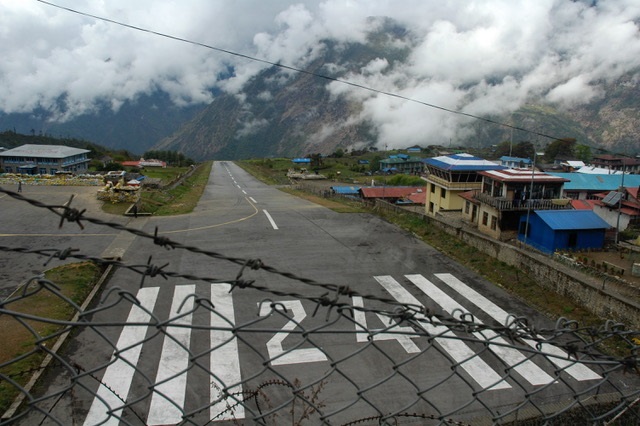


In the late Spring of 2005, a few months before my daughter was born, I took a trip to Nepal with two friends. Our goal was to climb a relatively easy peak, by Himalayan standards, called Lobuche East which overlooks the approach to Everest base camp. My climbing experience was minimal but I knew some basics like using an ice axe, wearing crampons and how to tie a rope. The friends I would be hiking with were somewhat more experienced, mostly from climbing 14,000′ peaks in Colorado. Mark, the only of us who might honestly claim to be a climber, planned the trip with a low-priced trekking operation in Kathmandu. A few days into the trek we made a practice and acclimatization climb up a hill overlooking the hamlet of Gokyo called Gokyo-Ri. On the way down I began to suffer from a stomach virus that got really violent by the time we returned to the tea house.

I have never been so sick before or since. The next day I sucked it up enough for us to cross a dry glacier to an abysmal hovel called Dragnag; really nothing more than a shoddy tea-house set up for the occasional trekkers doing routes like ours. Tea Houses in Nepal are awesome but rustic. Typically, there is an outhouse, a dung-burning cook stove and a single lightbulb hanging from the ceiling in the common room powered by a car battery. The house in Dragnag was more like what you’d expect to find on the wrong side of the ice wall in Game of Thrones. Other than its striking bleakness, it followed the basic tea house pattern. This time though, also attached to the battery was a radio with a placard affixed explaining how to call an Mi-8 in an emergency. My climb was over. And I came very close to using that radio.
Instead, the next morning I watched my friends make the hike up the snowy pass toward Lobuche. They left behind poor Dorjee Sherpa who’s task it would now be to carry all of my stuff back to Namche Bazaar while I took “breaks” behind every rock. We finally agreed that I would go ahead and he would follow an hour behind to allow me some privacy. Other than that I have no memory of the two day walk back to Namche. I do know that I had lost so much weight that my wedding ring was lost when it slipped off my finger–a fact I didn’t notice until a week later in Kathmandu. I still have the “goodbye” letter I wrote to my pregnant wife from Dragnag.


The truth is that I had succumbed to some of the melodrama that can come from a life of being a pampered westerner. I probably wasn’t actually all that sick. A few days of sleep in Namche Bazaar with the aid of lots of electrolytes had me healthy enough to practically run back to Lukla.


Still, the memory of the failure burned just enough that I’ve given the trip little thought since. That is until a few days ago when I first flew around the Everest Park 3D scenery. I wondered if I could remember enough about the route to fly visually and unaided to Gokyo and then across to Lobuche then Everest. (I could.)
A few things struck me. One is the recollection of the utter beauty of a particular mountain called Ama Dablam. Flying around it or any other peaks with Google Earth VR gives one none of the sense of the geometrical uniqueness of each peak. Google Earth diminishes big topography down to the significance of a model railroad. The scale is lost. But in X-Plane, this peak is now presented exactly as I remembered it–a little like the Matterhorn but bigger, and even more outrageous.
The second takeaway is how short are the distances between Lukla, Gokyo, Everest and Tengboche Monastery. I think it took us three days to hike from Lukla to Namche. (Due mostly to altitude gain restrictions rather than walking time.) A helicopter can fly between the two in five minutes. The compactness of the region allowed Dainese and Bellini to reproduce it in such detail that the parts of it that I’d experienced were immediately familiar.
The third takeaway sounds obvious but until you experience it virtually or in reality: you probably don’t realize how big Everest really is. I saw it from the summit of Gokyo-Ri but it was framed by other peaks, perhaps bigger but not dramatically so. Flying around it in a performance-limited machine like a Bell 412 is totally humbling. Three years of flying VR and I thought those early experiences of having my breath taken away were over. It’s good to know that my ability to feel nerd awe is still intact.
If I had one wish for the Everest scenery it would be that the major trails between villages were depicted. Without them, each hamlet seems to be an island, cut off and disconnected from the rest. Given the meticulous detail of the mountains, the added effort of laying a few dusty paths would have provided some sense of humanity to the experience.


I regret not having been able to write this in time for the most recent sale at the “dot org store” but I was busy snagging deals of my own. At retail, each “park” sells for between $22 and $28. If grabbing multiple modules at that price cuts too deeply into the sim budget I will offer my favorite, Eiger Park. (Keeping in mind that I don’t own everything.) Eiger may not present a peak quite so unique as the Matterhorn but the park as a whole has the most replay appeal. There are two dramatic valleys connected by an impressive pass. Several layers of resorts and cableways overlook the valleys below. The Eiger and Matterhorn sceneries apparently share a corner. While there is not a continuous string of artwork connecting the two, the HD topography makes flying from one to the other feel seamless. There is potential for some conflict between the Eiger and Matterhorn parks as well as some conflict between Eiger and the existing X-Plane autogen scenery around Interlaken. Resolving both takes seconds by following the instructions linked when you download the files.
Planes and Helicopters depicted:
- X-Trident Bell 412
- Freeware Bell 429 by “Timber61”
- Just Flight BAe Hawk T.1
- VSKYLABS C-47/DC-3
Eric “smokinhole” Anderson