Yeah. That’s what I am trying to do but it is hard to sort through everything. I may just take a rustic Carenado plane and pretend. I mean a Cessna 172 ain’t gonna win a race ![]()
So off I go…I’m going to fly this leg in daylight. It’s near 6AM there in London, but nearer 1AM here, so I won’t be able to wait every night until the sun comes up unfortunately.
WX in Mildenhall looking pretty nice for our departure…

No WX for my destination at this hour - Alderney (EGJA) but nearby Cherbourg with southeast winds at 17kt and a relatively high ceiling of 2,400’.
Navigation looks to be not too troublesome. Fly southwest until spotting the Isle of Wight, keep looking across the channel and find that island just off the coast. Now…where’d I stow that liferaft?

In theory - you should be able to follow along here, although I won’t be watching that map…so I won’t consult it until I land!
3 Likes
What a meandering course. I should have set something other than sunrise…the haze was a bear. I was actually starting to get a bit nervous on the bit over the Channel but I picked up the Alderney NDB about 40nm out and it agreed with my dead-reckoning heading. Will post up the details tomorrow.
T/O TIME: 0605Z
LANDING: 0807Z


Good VFR checkpoint…!

Not sure what is up with the wingtip vapor trails…temperature/dewpoint were equal-ish…but that still shouldn’t happen. Must be the DCS Beech 18…!

6 Likes
While I don’t do civi flight sims (yet) I do love these community flight things you guys do. This one ought to be even better than the xmas flights. Looking forward to reading all these posts.
1 Like
First things first ! ( I had v11.30 just for testing until now so no scenery installed )

Next will be the plane… I need hurry up its a race ! ![]()
4 Likes
EGUN (Mildenhall, England) - EGJA (Alderney, Channel Islands)
190 NM
Leg Time: 2:02
Total Time: 2:02
Firing up in Mildenhall…

Good weather for the entire route, but very hazy with the rising sun. Consulting my SkyVector map throughout, looking for landmarks. As usual, airports turned out to be some of the best indicators of being on (or off) course…

Passing by Duxford…

The lights of Heathrow coming out of the early morning haze…

Lovely detailed ORBX South England scenery slides by…this won’t always be the case on this trip…
Supplies for the party in Melbourne…


Learning my new aircraft. GPS and NAV radios are set to INOP. A finicky ADF receiver can only be tuned below 400 kHz for some reason…so I need to figure that out. A bit worried about EGT, oil, and cylinder temps - cracking open the cowl flaps seemed to bring the CHT down a bit, and running rich at this low altitude…

Crosschecking the map…this appears to be the Portsmouth area…with Isle of Wight ahead (as planned)…

Running along the southeast coast of Isle of Wight…

Over the water for a short spell…hoping that holding a heading will get me to the island of Alderney - the NDB flickers to life at 40 or so miles out…

Nice weather conditions…a bit of a brisk wind blowing…

Lining up on one of the grass runways…

Down safely! Active on the rudders to keep the Beech from ground-looping…

First hop is in the books!

Flight tracking map that I did not look at enroute…
8 Likes
In good British fashion, I started my air race a couple of pints deep to settle the nerves.
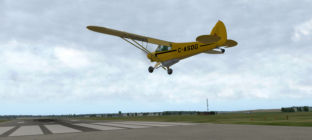
It was getting late but I was itching to get going, so I chose to start the race with the closest bird to the era I have in the hangar, the PA-18 Super Cub. I’m just going to imagine that it’s a J-3 Cub, which first flew in the 30’s.
My bird is a pretty canary yellow to make it easier to spot should I crash:

After a thorough external preflight (two wings, check), I fired the starter and the engine roared to life. Well, sputtered to life.

Oil pressure came up quickly and I waited patiently for a few minutes at idle to warm up the engine. A quick check on the extensive electrical control panel and we were good to go.


After some consideration, I decided to fly Southeast towards the coast, roughly heading 170 and try to reach Southend-on-Sea, some 45 nm away. After waving at the crowds gathered at Mildenhall, I took off into the grey skies! We were off!

The weather wasn’t great. At 2000 ft altitude, my poor Cub started to get thrown around quite violently and I was almost considering turning back. The air at 1000 ft altitude seemed to be calmer, so I stuck to the low altitude and pushed on - I didn’t have far to go so fuel efficiency wasn’t a problem.

While I wasn’t particularly worried about finding the coast (it is an island after all), it was nice to see the waters of the Channel in the distance:

After spotting the coast, it was a matter of figuring out where along the coast I was. The pints had done their job at easing my nerves but I’m afraid they had a negative effect on my course-keeping ability. Luckily I brought along a map and after a little bit of searching, I recognised the body of water off my port wing as the Abberton Reservoir, about 9 NM North of Southend. Not too shabby, old chap!


Unfortunately I had been a bit sloppy at trimming and while I was pouring over the maps, the Cub happily climbed a full 1000 feet and when I looked up, I found myself in full IMC. It was at this point when I realised that the cockpit wasn’t really geared for such flight!

I gingerly pointed the nose down and watched the ball, the altimeter and the compass, trying to determine whether I was still wings level. Luckily this worked and I emerged back out under clouds unscathed over the water, a little bit further East than intended but happy. I took a course towards Osea island on River Blackwater and turned South over the island, towards Southend.


It was nice to see the blinking airport light in the distance.

First leg done! It was a short one but at least I am on my way.
Flight time - unsure but we will call it 40 minutes.
9 Likes
Ha…when I used to flight instruct in Myrtle Beach, I used to tell my students - hey…if you get lost…just fly southeast until you hit the ocean, then flip a coin and turn left or right…you’ll either hit Charleston or Wilmington…then you can figure out where you are. ![]()
2 Likes
Is there a list of NDB stations implemented in XP11? I tried to plan routes on Skyvector.com, only to find out some NDB were not available in XP11. And the range seems rather short. I was able to pick up the signal only within 16NM or so to de Gaulle airport Paris. That normal?
1 Like
I was not able to start last night as I spent too long researching aircraft but today, in between fires, I pulled this together - the first part of my proposed flight plan.

Each leg is around 125nm, with a few in the 250+ range, that travels between airports with an NDB beacon and attempts to stay over land. I am willing to share this plan with my competitors if it helps their navigation challenges ![]()
4 Likes
Oh. Well that is going to make it more difficult than I thought.
Me too!
And they’re off!.. ![]()

Map here: https://forums.mudspike.com/u/user-map?period=location
MOD: Fixed your link ![]()
MOD2: Refresh your browser /u redirects! ![]()
2 Likes
Ironically I picked a start date, that was horrible for me. Oh well, home now and time to do some flying.
Here is our route for our first leg:

Approximately 500 NM, and basically designed to help knock the rust off over relatively safe terrain and plenty of landmarks and NBD’s to work with. Screenshots to follow.
4 Likes
Southend (EGMC) - Gatwick (EGKK)
Leg flight time 00:29
Total flight time 01:09
Leg distance 50NM
Total distance 95NM
Leg details
Live weather through ActiveSkyXP but NZ daytime used (otherwise I’ll be flying pretty much only at night).
The planned route:

It was a foggy day at Southend with light Easterly winds and no rain but poor visibility at surface level:

Rolling down Southend RW 05 on the main wheels. The tail lifts itself up nicely - the Cub is a lovely little plane.

Off into the fog I went. The weather report showed no clouds so I hoped to see some better weather higher up. I took off due East given the winds and circled around towards SW once I cleared the airport. I forgot to set the altimeter on the ground - should follow checklists. The good people at Southend were happy to confirm 29.68 inches over the radio.


The weather was nice and sunny, if a bit hazy higher up. I climbed to 5000 ft and trimmed the Cub for cruise, heading 240 towards Biggin and Gatwick. I could see a little bit of cloud forming in the West - something I should keep an eye on. The river Thames was snaking under me until she turned West towards central London and we parted ways.

I checked the fuel levels after having cruised for a little while - something I should have been a bit more careful about on the previous leg: today’s preflight before refueling revealed that there was just one kg of fuel left in the port tank!


Switching tanks:

After a while, I could see some bright lights in the distance. Gatwick or Biggin, surely. It wasn’t until I got closer that I could make out the dimmer lights of Biggin, thus identifying the more brightly lit airport as Gatwick. A little course correction to starboard and all was going as expected.

It was around this time when the little clouds I noticed earlier had started to form into something more substantial West of my location:


Although I knew where I was, I could no longer see either of the airfields. I skirted the clouds flying direct South and started to descent in hopes of getting a better view from underneath. Unfortunately it seemed that the clouds were descending as quickly as I was.


In the end I took a gap towards the West where I estimated Gatwick to be and hoped for the best. I don’t think I really had sufficient clearance but beggars can’t be choosers and it is a race after all!

Luckily, I was right - Gatwick runways revealed themselves from under the heavy grey clouds that were now rapidly becoming overcast at 500 feet. The light changed so quickly.

While I was approaching the airfield, I glanced at the map. I had hoped to get to Tangmere, another 28 NM SW. The overcast was solid now. I could try scud running it for another 20 minutes, get a bit further. I quickly decided against it, though - I had already taken a gamble today by shooting that gap between the clouds to find Gatwick; while there was still a bit of space to fly underneath the overcast, there was no guarantee it would stay that way. Don’t let get-there-itis get you, old chap.
I whipped around for a short final and almost got caught by the dropping overcast halfway through base.


On the ground, safe and sound - but that got a bit more serious a bit quicker than I expected!
5 Likes
Alright. On the move again. Heading out from Alderney (EGJA) down south to San Sebastian, Spain (LESO). Shouldn’t be hard to navigate - keep France on the left and things should work out right?
Live flight tracking: http://xfsd.ansorg-web.de/fsdmap/

If you guys are flying real time weather, but not realtime sun position, don’t you get night weather during the ‘day’?
No, you can separate out the two - you can set whatever time of day you want, and the weather just updates constantly to show current (realtime) weather over whatever manually set time you want.
Got lost for a bit. LOL…was furiously trying all nearby NDBs without any luck (they seem pretty short range in X-Plane). Weather has been driving me lower and lower…started at 10,000 and now down to around 2,000’ trying to keep the beach in sight. Did spend about 15 minutes unsure of where exactly I was…never a good feeling!
2 Likes
So if you set it to say 07:30 Local, it gets the weather from an archive or something?