I thought this one particularly nice.

9 Likes
Today I’m leaving Kopenhagen and fly to Kristiansand in Norway. Once more, the FW-200 Condor will be carrying me over land and sea. For a change, I will try to minimize the GPS on the tablet and see if I can find Kristiansand via the ATC radio.
Take-off from the long runway at Kopenhagen is hardly a problem. The Condor’s wingspan probably attributes to the rather short length of runway it needs to get airborne.

Kopenhagen passes away to my right.

After a few miles it is feet wet and we go over the sea. I guess I should download this ship and sea traffic mod? So for me the sea is wide and empty.


The autopilot is set to 313 degrees, we fly at 3km height and with 300 km/h. Lucky 3 I hope!

On my way I’m passed by an airliner that somehow manages to fly lower than I…

I change the mixture of the engines with the levers on the throttle and gradually lower them to 50%, without noticing an impact on performance. I wonder if fuel consumption is affected properly? Anyway, there should be more than enough liters aboard for this short leg.

And finally over the second patch of sea on my way to Norway. The Danish coast is slowly disappearing…

Time to search for the destination airport via the ATC radio. I drifted east it seems, no surprise due to westerly winds, which I did not attribute for in my heading bearing.

After two course corrections to 290 degrees (from 313), I’m headed towards to airport. It has to be somewhere in front of me.

And here it is, the radio navigation via the ATC worked nicely! The nice weather played a huge role as well.


Seems I’m landing with the wind, but in exchange I’m getting a view on Kristiansand before me on my ‘Downwind’ leg.

Wheels out, here we come, Kristiansand!

With the less than busy airport, I do some practice taxiing, which is in bitter need. First I end up facing the wrong way of the taxi path.

And then I will definitely use a push back, while the fuel truck simply abandons position and flees the scene, backwards.

Anyway, Norway, here we are!
15 Likes
Nice. I just left Kristiansand yesterday evening (AAR will follow soon). What’s your next destination?
2 Likes
Hey, my plan is to go to Bergen, ENBR, and stay close to the fjords/coastline for most of the Trek. Bergen is the original home of my arma 3 buddy blud, so have to pay a visit ![]()
4 Likes
Time for another flight, this one will be pretty simple.
EPPI → EPDA → ESMA → ESSP → ESSK → ESNN → ESUA → ESNQ → ENGF → ENSB
Leg 5: Gavle, Sweden - Sundsvall Timrå

I’m sticking with the Cessna 152, livery unchanged, but I made modifications to my tail number.

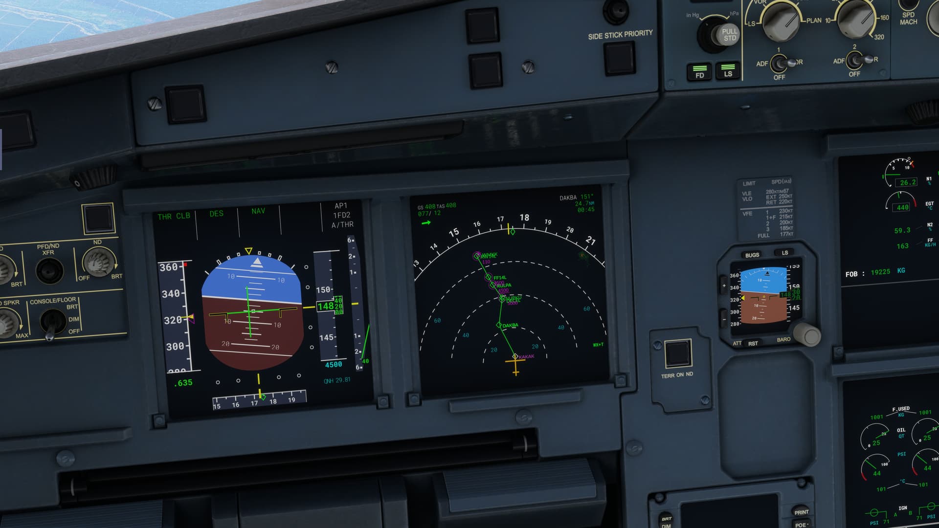
I will be flying straight for the SUNDSVALL VOR which is conveniently situated at our destination airport. There is another VOR station to the left of the track - FARILA VOR which I can use to triangulate my position since we don’t have DME on board. I’m setting up the NAV radios while the engine warms up.

I taxi to the runway with the simplest flight plan there can be, take a look at the wind sock to judge the wind speed and direction (there’s no ATIS here).

Since the wind blows from the south, I turn left and don’t bother with going right and turning around since this runway is 2km long and the taxiway meets the runway at midpoint giving me plenty of space for a take off.

There was some slight crosswind, but nothing too severe. The weather is pretty good too, broken clouds with base at around 4000ft.

I do a 180° to the left for a closer look at the city of Gavle.

After short while I got a signal from NAV1 radio (SUN VOR), NAV2 remained silent though. Spoiler alert - it would for the remainder of the flight, I find that some VOR stations are absent in MSFS2020 (at least for Europe) or maybe they have different freqs in MSFS database, lets just pretend it’s down for maintenance.

Another discrepancy - on my way I notice an airfield (Soderhamn ESNY) which is mapped in skyvector and clearly seen on the aerial textures in MSFS but not in its database.

Here’s another MSFS2020 curioisty - you know how the procedural vegetation is done? Well, its color is being based on the terrain it’s being placed on. On my way I found an island with overly bright coloring, with trees that ended looking like properly colored leaves for fall season.

Autumn trees - no ,modding required ![]()

Since the route for fhis flight was pretty basic I decided to spice things up with a bit of touch-and-gos.

Aproach to Hudiksvall - there’s a lot of traffic on the E4 highway. In fact we will be flying along this highway all the way to the Sundsvall. Also there are rows of solar panels running next to the runway on the right, not depicted in MSFS.

After a short contact with the tarmac I take off and circle back on the route.


I’m not far off from my destination - time to check the ATIS for weather and active runway.

Nice, runway 34, it will be straight in approach. I also transfer the NAV1 → NAV2 and put ILS freq into NAV1.

At this point I’m entering Class C airspace (running from 20 to FL095 according to skyvector map) so I’m getting a clearence from ATC. In Sweden anything above FL095 is controlled btw. Most of this flight was taken thorugh Class G uncontrolled airspace.

Getting clearence to land - I’ve been assigned runway 34, which as you can see the NAV1 is already receiving ILS singnal from.

Sundsvall to my left.

Turning right, over Alnön Island on my way to intercept the runway 34 centerline.

Turning left into final approach.

Really picturesque view.

Highway E4 we meet again.

Safely parked. Looks like I’m beyond the mid-point of this journey. I have to admit, this is great fun!

14 Likes
LEG 6: Don Mueang International Airport, Bangkok, Thailand (VTBD) TO Kuala Lumpur International Airport, Sepang District, Selangor, Malaysia, (WMKK)
Amazing reports guys! Makes mine mundane, but oh, the alliteration! ![]()
I needed to start putting some air miles behind me, so I moved on to what will probably be one of my prime movers here, the A320.
I own the Fenix version and also quite like the FBW mod for the default Bus. But, in the interest of sticking close to what Asobo offered in the default release of MSFS (minus changes since then), I decided to try the Vanilla version first.
Also. since I have some time in the 320, I was curious how I would fare vis-à-vis trying to figure out the jet. Would it all work, more or less, as it does in the real aircraft? Or would I still be hunting for stuff as I had my last few legs?
Let’s see.

Today’s leg would be an easy 674NM from Bangkok to Kuala Lumpur across the Gulf of Thailand.

The front office looked familiar on a steamy October morning. I did manage to program the box using my typical flows. Not everything was accessible, but I felt that it would get the job done.

I pushed the thrust levers up to the FLEX detent just as the sun broke the horizon and we were on our way!

She sure climbs like a NEO! I couldn’t help but admire the wing flex that Asobo programmed in…very immersive.


I began to run into some system issues shortly after takeoff. The Bus is fairly automated, and it should automatically command pitch downs, accelerations, etc. based on the programming in the box.
But, in this case, the aircraft seemed to be behaving differently than I would have expected. It’s certainly possible that I had missed something, or that there is some difference in the box that would have performed the function that I was hoping for via other means. But in this case, I had to degrade the automation a bit and fly it more like the 737, which is no worse…just different.
Soon enough though, I was clean and climbing out over the Chao Phraya River on my way to the Gulf of Thailand.

Pattaya Beach, off the left wing. I’ve heard many a sailor’s and Marine’s tale of that magical place. In my case, our ship had pulled into port further south, in Phuket. I had no complaints though. What a place! ![]()

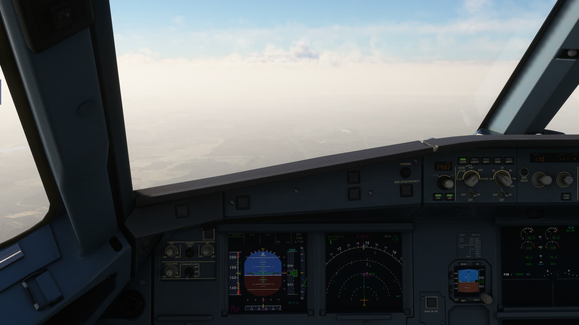
The eerie half-light between the cloud decks really showed the texture work of Bus to great effect.
Quite nicely done, IMHO.

The monsoonal rain showers that had been stalking me since the Himalayas were still present this morning.

Luckily nothing looked too terribly convective.

At about 480kts ground speed, the time to prep for the arrival came fairly quickly.
There were some, um, programming challenges. ![]()

This wasn’t the first time that what the box showed didn’t appear to be exactly what I had selected. But, with a little jiggery pokery and strategic transition selection I got her straightened out, pun intended, about the time that the southern coast of Thailand hove into view.
Here near Ban Budi.

The weather cleared and the sky turned spectacular as I crossed into Malaysia. The sky, the clouds, and the misty mountains were a study in blue.


Having programmed the box successfully for the arrival, including altitudes, I was curious to see how well the VNAV (or, as Airbus calls it, Managed Descent) would work…particularly since the cruise, optimum, and maximum altitude displays remained blank.
I can’t think of a reason that this would be so in the actual aircraft, so this was going to prove interesting.

Not entirely convincingly, as it would happen. The jet really seemed to drop out of the sky in a hurry. I’m not certain that it was attempting to follow a path at all. As always, there is the possibility that something was missed, but I’m fairly sure that I programmed the box (as possible) as I would the real one.
I wonder if an external flight plan might have been necessary… ![]()
In any event, the prodigious descent gave me ample time to appreciate the Kuala Lumpur city scape, including the Petronas Towers out in the distance.

I had chosen the ILS for the arrival, which proved to be fortuitous. The vis near the airport dropped considerably.
I barely broke out the runway near mins.


And taxied her to the gate.

Another leg down.
So, how did the Asobo Bus do? Honestly, not terrible. The jet certainly flew nicely enough. And the basic autopilot functions worked well.
As for some of the Airbus esoterica, I’m less certain, though I should probably withhold judgement until I do a little Youtube research to see if there is a MSFS 320 FMS tutorial.
This feels to me though like one of those cases where, in an effort to simplify a complicated aircraft or system, the result works less well and is in fact more impenetrable than the system which it struggles to streamline.
Which is why I sometimes feel badly for novice simmers (and in certain circumstances that includes myself) who attempt to master a simulation that asks you to solve a puzzle…without perhaps supplying all the requisite pieces. ![]()
12 Likes
Amazing shots there. Really sells the game ![]()
Also great job on the landing with limited visibility. Putting down heavies with their large inertia always presents a challenge to me.
4 Likes
But. You are doing many more miles (than) most ![]()
3 Likes
Hehe, nice!
3 Likes
EPPI → EPDA → ESMA → ESSP → ESSK → ESNN → ESUD → ESNQ → ENGF → ENSB
Leg 6 Sundsvall, Sweden - Storuman, Sweden
I planned to make this flight yesterday, but the conditions weren’t good for VFR.

Also I exchanged the Amsele AB for Storuman, since Amsele is not mapped on skyvector and there are no VORs in vicinity, which with the currently mixed weather worried me a bit.
The plan is to head for the RAMSELE VOR and then head straight for STORUMAN VOR (which is placed at the airport).

After setting up the cockpit I grabbed ATIS and contacted ground for clearence to taxi.

At the hold short I contacted tower, turned on landing and strobe lights, switched transponder to ALT. Got clearence for runway 34 which put me directly on course after take off.

There wes slight cross wind and pretty severe turbulence. For now I need to stay below the cloud deck which was reported at 1600ft above the airport.

While cliimbing I was waiting for the signal from RAMSELE VOR, which was worryingly silent. No biggie, I can just fly outband on 330° from SUNDSVAL VOR for now - I entered its frequency into NAV2.

After a while the weather seemed to be clearing up…

… so I ascended in hopes of receiving the VOR signal entered in NAV1, to no avail.

Soon I would have to drop down again, I didn’t liked that view at all.

With the clouds base getting lower I opted for a little sidestep above that long lake where the terrain elevation had to be lower.

My plan was to follow this valley until the weather clears or I get the signal from the VOR.

By my calculations I should be approaching tha VOR and my turnpoint soon. But NAV1 was still dead. Time for putting the mark 1 eyeball to work and orient myself on that map.

I recognized those 3 lakes, so now I had to turn right to 21° (corrected for wind) after passing that 3rd lake.

Turning north.

Now I would constantly had to identify the terrain features (mostly lakes) and cross check my position with the map. So I did.

Interestingly, some lakes in MSFS2020 didn’t had the water mask applied (are treated as plain ground).

The weather got worse further north. I hit some precipitation. I dialed in the frequency for the STORUMAN VOR into NAV1 and thankfuly this one worked.

After 30 minutes I finally arrived - the weather was really bad.

The airport didn’t had CTAF, so I had to look for the sock to check up on wind, in this weather finding it was a challenge.

With the wind coming from the south, I immidiatelly entered downwind and configured for landing.

A bit high on short final, but this runway is so long I can afford for that.

Despite the turbulence the touchdown was smooth.

Parked near a TBM, might borrow it for the next leg ![]()

14 Likes
Kristiansand to Stavanger, 87 nm.
I was curious whether the engine(s) would fail on me again so I took the 18 (as the book says) for this leg. Of course I reset the engines to “as-good-as-new” condition.
Full throttle - no sorry, max take off power - and off we go!

(note the windsock indicating tailwind; that’s what I got for complying with ATC instructions)
Topdalsfjorden below me and Kristiansand ahead.

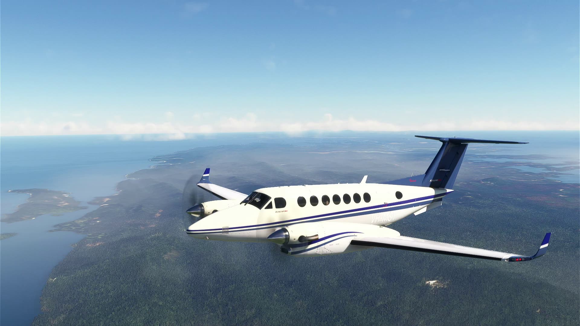
Climbing to cruise altitude. This was a short leg for the Twin Beech.

Love those radial engines!

Where are all the people? I mean… I know that Norway is not as densely inhabited as some other European countries… but here we are still in the southern part of the country which I would expect to be a little less empty.

Stavanger.

And here I have a story to tell.
When in my early twenties, I went with a friend of mine to Norway. Hitchhiking. Back then it seemed to be a good idea promising some little adventure. Only somehow we underestimated the weather as we left in late September.
Anyway… I will spare you some boring parts of the story (like being escorted by German Police off a highway, running out of money and riding a train as black passengers [did not work]…) and jump right into Stavanger. While I do not want to talk too much about that night we spent on the cemetery, the story I want to tell is actually linked to it.
At some point we were standing in front of a memorial of U.S. pilots who were shot down in the area and fell. The captains were probably as old as we were and the rest of the crew even younger. That was an eye opener for us to realize how lucky we were with our lives.
Runway in sight. Both engines running smoothly.

On final…

…and on the apron.

The next leg is longer and also takes me over high(er) terrain. I am contemplating the DC-6 because it is so good or the Transall for the same reason ![]() We shall see.
We shall see.
13 Likes
Leg 6
Before we get started, let’s review what we’ve accomplished so far:

Svarlbard marked with an X. We seem to be about a quarter of the way there. I am stubbornly adhering to my “not having a plan” plan, so I can’t say precisely how far I’ve got to go – that depends on my whims as I travel – but I’ve done 4,139nm so far (only some of it doubling back
So my whim today is to get to India. I’m in Kuala Lumpur, so that’s not going to be as obviously easy as it would be for an airliner … fortunately India has some island territories in the Indian Ocean I can end my flight in!

Our route for today takes us north past Butterworth, then west across to Aceh in Indonesia, then island hopping north to Veer Savarkar International Airport (VOPB), Port Blair, in the Andaman and Nicobar Islands territory.

Starting up, this big boy and the service truck spawned in between when I started programming my FMS and when I looked up to get ready to taxi!
We’re doing an IFR departure from WMKK, since it’s so busy. And it was a good choice:

Another King air on departure (in the red circle) … Traffic sighted!

Turning onto track over the Ayer Hitam Forest Reserve.
After the normal left and right and up and climb to … expect … that MSFS gives us for an IFR departure, we make our way to RMAF Butterworth.

Again, the clouds weren’t playing nice, but you can see the distinctive apron.
Back in the late 1960s and through to 1988 the RAAF provided what we’d now call air policing out of Butterworth using Mirage IIIO fighters, and under an agreement with the Malaysian government are still a co-tenant at Butterworth although we don’t routinely base fighters there anymore (the TUDM has that covered these days with their F-18D Hornets). Recently, the RAAF invested a fairly large sum of money to improve the facilities at Butterworth so F-35A could be deployed there, I’m not sure exactly what that entails in terms of buildings on the base…

(Image Courtesy Australian War Memorial)
I see that there is a Mirage IIIC mod for MSFS … perhaps I should try the deployment from Williamstown NSW to Butterworth … but I have to finish this trek first!
After crossing the Malacca Strait we make landfall near Lhokseumawe City in the Indonesian province of Aceh.

The Perta Arun Gas export terminal just ahead of the starboard wing.
Heading north towards Port Blair, we’re going to island hop … but as you might have noticed the FMS doesn’t have Campbell Bay Naval Air Station Airport in as a waypoint – there isn’t an identifier in MSFS for this place and I didn’t feel like learning if the FMS supports Lat Long waypoint entry today…

So instead we tune 113.4 for Banda Aceh VOR (BAC) and head outbound on the 315 radial for about 130 nm (I thought I was being smart, but I guess I was just channelling Damson

And we overfly as planned - the runway is visible just behind the starboard wing

Final waypoint, overflying Car Nicobar Air Force Base.
We’re close enough to get the Port Blair ATIS and the weather isn’t sounding great …

Or looking great either
We get cleared straight in for Runway 04 … but I program the 04 ILS in the FMS just in case …

Yeah, visibility isn’t great!

Runway in sight!

Wait, that’s the under-run!

Down safe and parked up

Just over 5,000nm completed
13 Likes
Funny how certain places will just jump right off the page at you. Now I have never been there personally but I have been there numerous times virtually trying to keep Singapore from falling to the Japanese during 1942. ![]()

Wheels
11 Likes
Yes absolutely!
If we ever get global terrain for DCS I think I will set up a “Final Countdown” scenario to see how 75 squadron’s Mirages deal with the invaders ![]()
![]()
4 Likes
I have done an A-10C over Normandy… Those Panzerkampfwagen IV’s don’t stand a chance against 30mm brrrrt ![]()
7 Likes
it was already too late yesterday ![]() … but lets see what MSFS24 will bring with their take on multi-threading
… but lets see what MSFS24 will bring with their take on multi-threading
5 Likes
EPPI → EPDA → ESMA → ESSP → ESSK → ESNN → ESUD → ESNQ → ENGF → ENSB
Leg 7 Storuman, Sweden - Kiruna, Sweden
As I mentioned in my previous report, for this leg I will be taking TBM. The weather detoriated badly, sadly this will not be a scenic flight. The forecast says we have cloud cover from the deck all the way to FL300. Great…
Also I spend all night repainting that Daher TBM930 I found on the apron yesterday. The owner didn’t mind, even got me the keys ![]()

So, this is the basic flight plan, after I get this beast up and running I will try to work out how to input this into that fancy Garmin G3000.

I swear, that start-up procedure is longer than in DCS F-16 Falcon, thankfully there is this nifty checklist feature in MSFS2020 that makes it a breeze. (mostly)

I had to change the brightness on those screens, since in this low light level environment they were blinding me. After a minute of browsing through numerous options I finally have found the setting.

Allright, with the engine started I began entering the flight plan information.

Selecting starting airport…

…not many departure options.

I’ve selected the only arrival I was able to find for Kiruna, later I noticed there are more available (though it might be from another option?). The approach will be to runway 21 with ILS.
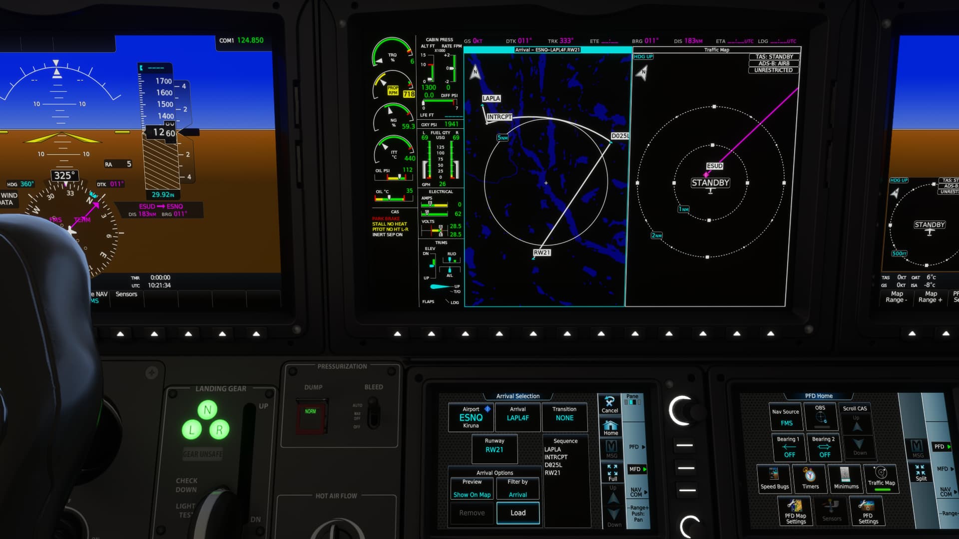
The best thing I could come up without RTFM.

Neat, you can even see the status of the GPS, I wonder fi the satellites signal etc is computed based on your position in game world or this is some fake info just for show.

LOL, you can even change Bitching Betty into Bitching Bob ![]()

Checking the weather on route through Connext Weather service. Looks bad all the way.

Allright, I think I’m all set. Requesting pushback, though I don’t think that’s safe with the engine running ![]()

I taxi into the active runway not forgettting to turn on required lights and transponder.

And we’re off…

I had to remember to contact ATC after passing FL095 since from this altitude Class C airspace is established all over Sweden. Most of my ascend looked like this though.

I noticed ice forming on the windshield…

…with pitot-heat and inertial separator switched on since the take off, I added windshield, prop and airframe de-ice as well.

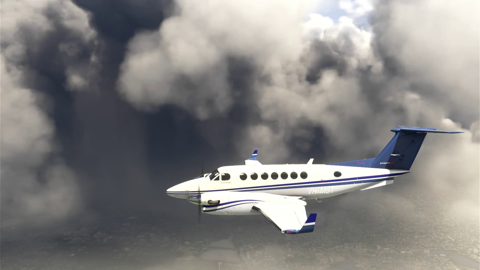
From time to time I would break from the clouds only to hit another layer moments later.
A nice feature - you can display visualization of which components are being de-iced on the central display.

At around 29000 ft I broke the cloud layer (you can see the decreased brightness of the displays due to more light coming in from outside the cockpit). I got a warning about the cabin pressure difference, but I continue to climb wanting to see how high the TBM can go.

At 33000 ft I got another warning - “CABIN ALTITUDE” and a master caution - “USE OXYGEN MASK”…

… which I promptly donned, unfortunatelly my co-pilot didn’t packed his and sadly had to take a nap missiong my altitude record attempt.

After reaching FL400+ (not pictured, you have to believe me) I engaged the autopilot to bring us down steadilty to 18000ft while I was tinkering the G3000 some more.

Around 70nm from Kiruna the weather cleared up slightly, at least the part from FL018 - FL030 was clear. I continued my descend.

The cloud cover on the right seemed even thinner.

I checked my Connext Weather thingy and noticed that the weather at Kiruna was pretty good, we will soon find out.

Eventhough the weather blocked the view of the ground on this flight, the sights were still magnificent. This is what the passengers would see if I had them on board (well unless they were napping due to lack of oxygen like my CP).

I was approaching Kiruna - time to contact the tower.

That’s was I afraid of, without properly filed IFR plan I was denied the landing. Thankfully there is option to “ignore the weather” in such situations.

Permission granted, though it looks like VFR type approach which I will ignore and proceed per flight plan for ILS 21.

I noticed that my final waypoint lacks its elevation (could be needed for approach autopilot?), so I promptly enter it from skyvector airport data.

Speaking of approach, need to put in ILS freq into NAV1 (I assume the smart G3000 doesn’t do it for you?), but it’s only few clicks away and you don’t even need to know the frequency - it’s in the G3000 database.
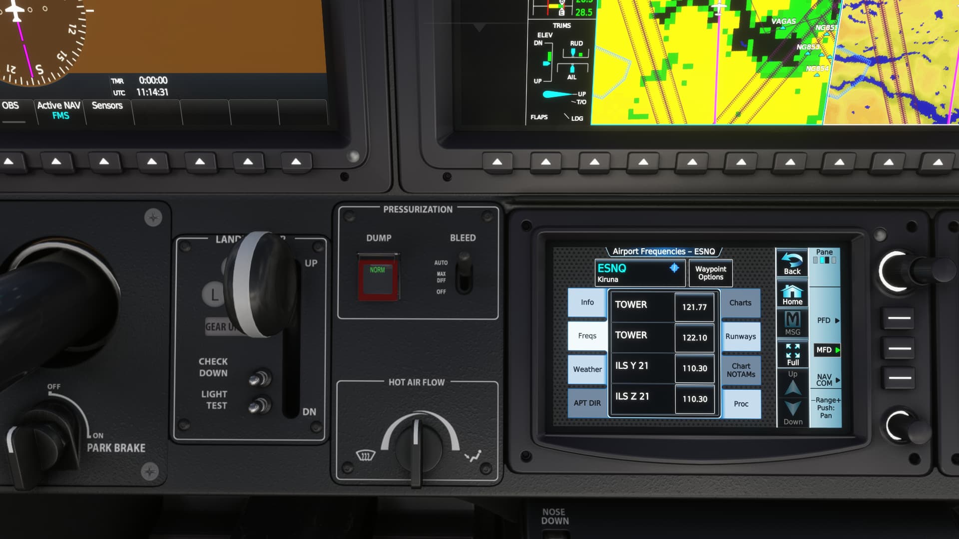
Super-easy.

Also found this nifty weather status page at desired airport page.

While descending and going through clouds icing was again a problem. Nothing the de-ice system couldn’t handle though.

Seems that weatherx-something was right, I could see an opening in clouds in the general area of Kiruna.

Before entering the final turn I switched Active Nav from FMS to NAV1 and AP to approach mode to intercept the ILS.

Autopilot intercepted localizer and glideslope properly, this is the moment before I broke out from the clouds.

Runway in sight! Disabling AP and taking control.

Parked, time to shut this beast off.

Turning it off took me few minutes, the price of luxury…

Actually I recorded the approach and landing so you can watch it here:

15 Likes
Cool report ![]()
I can see the TBM 900 made a great progress in terms of avionics since I flew it four years ago on 2020 Christmas flight.
6 Likes
Leg 7
There’s no avoiding it … we’ve got a long overwater leg this time.

Port Blair (VOPB) to Chennai (VOMM).

And the weather in Port Blair hasn’t improved much…
Since I didn’t really see much of the island when I arrived I decide to do a short VFR sightseeing tour while turning onto track.
The weather over middle and North Andaman is beautiful!
But looking back to the south …

On climb, staying outside the exclusion zone around North Sentinel Island (the island isn’t even shown on SkyVector!)

North Sentinel Island is home to the Sentinelese people, who I got taught in school were “one of the last uncontacted peoples on the planet”, who “violently defend their island from outsiders”. Like many things I was taught, a bit of googling and wiki-ing (yes, those are both verbs now

It’s going to be a long, boring leg … but I’m expecting a 10 knot tailwind at FL230

Yeah. Nothing much to see up here.
After an uneventful cruise we’re on descent to Chennai. Again, the weather isn’t good.

But I see land through the clouds!
The airport is off to the right there:

And a bit of rainbow from the sun on the clouds below!
Coming abeam the airport …
That’s not really what you want to see

Runway in sight!
OK, I won’t complain about the weather in Port Blair any more! ![]()

Maybe I should bind a button for the wipers?

An uneventful flight, aside from the weather hanging out at the airports… but with that tailwind I made good time ![]()
11 Likes
I was tempted to purchase the Hot Start TBM. but after remembering @PaulRix say how ‘realistic’ their Challenger 650 is, I thought that it would be way too much aircraft for me and decided on the Epic E1000 instead.
5 Likes