That has to be the first time an endorsement from me dissuaded someone from buying a product ![]() .
.
8 Likes
Careful, we’ll have to change your flair to “Good Influencer” ![]()
3 Likes
I’m obviously losing my touch! ![]()
4 Likes
I wouldn’t let that dissuade you @Harry_Bumcrack!
As I was alluding to earlier, sometimes the “harder” realistic aircraft is actually easier to fly, because the buttons and interfaces (not to mention the flight model) all work as some team of incredibly clever engineers intended them to…and not as some programmers had to simplify in order to make it “accessible”.
Plus, since you are always going to be following some checklist or another, following the actual checklist is arguably no more difficult than some truncated version. ![]()
I know I find flying a higher fidelity aircraft actually easier than a lower one, even if I’ve never flown that type before, if for no reason other than that I never need to wonder if what I’m doing isn’t working because I’m doing it wrong…or because that feature isn’t modelled. ![]()
![]()
Hopefully, I’ve resurrected @PaulRix’s nearly flawlessly, um, flawed reputation. ![]()
4 Likes
This. Oh so much this. I hate seeing the “INOPERATIVE” caption all over some of the default Asobo planes…
3 Likes
Leg 8: ESNQ → ENNA (Kiruna, Sweden → Banak/Lakselv, Norway)
The weather again was terrible, so instead of making another IFR flight in the clouds I opted for a little change. Well, maybe a big change - I switched the sim to another one. One from late 90s that surprisingly had both of the airports modelled. At first I wanted to do the flight in DCS, even recorded the take off (love that rain on the canopy)…

…but after seeing that the ENAT (Alta) airport wasn’t modelled there (yet) I switched to [drum roll] Jet Fighter: Full Burn. Yeah, I know it’s old but the terrain modelling reflected reality quite good for the time.
So, here’s my flight plan for this leg:

After take off from Kiruna i’m heading north towards Alta and then turn east to Lakselv. Pretty simple.
Here’s the map view from JetFighter compared to the one from SkyVector of the area around Kiruna.

On the ramp at Kiruna.

Taxiing to runway 03.

I punch in the burners, you can see the city to my left.

I reduce the throttle to 90% mil and proceed north. Sadly there was no way to import real-world weather here ![]()

Another comparison of terrain features in game vs real-life (near Alta).

Passing Alta on the north side, heading east. JetFighter models airports correctly regarding runways (amount of runways and their orientation), not so much regarding taxiways/aprons etc.

It models the power lines correctly though. Those I saw in the game were there in real life (confirmed in Google Maps).

I can see Lakselv in the distance (coming in from the north).

In this particular case the shoreline is a bit off - Lakselv in real-life is positioned near a shore in a bay, which is missing in the game.

Coming in for a landing, In real life I should be flying over water though.

Just before touch down.

I vacated the runway, parked and switched off the engines. It was a short flight compared to the other ones performed in GA aircraft. The next and last leg will be the longest one yet.

13 Likes
Wow! Outstanding call on the sim choice. And looking pretty good, all things considered!
5 Likes
LEG 7: Kuala Lumpur International Airport, Sepang District, Selangor, Malaysia, (WMKK) TO Paya Lebar Air Base, Paya Lebar, Singapore (WSAP).
I love this yearly flight. What are the odds that, on a trip to Norway, I’d meet so many Mudspikers…in the Malacca Strait? ![]()
This next leg was to be fairly short, right down the strait from Kuala Lumpur to Singapore, 156NM. So I was looking to cross one of the slower aircraft off my Christmas list.

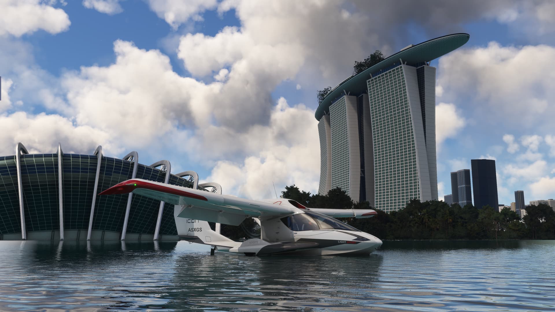
I had had notions of making use of some of the sea planes in their natural environment. It is the southern seas after all. So I pushed the Icon out of the hangar. This is really a cool little aircraft that I hadn’t done much with in MSFS, save for a landing challenge or two.
Maybe, I might even get it wet!

She took off in about ten feet. Hopefully, we don’t run out of gas before the end of the runway!

Because drilling over jungle in the haze felt like it might be a bit dreary, my first assignment was to find the coast nearby.
Here she is, right at the mouth of the Sungai Sepang (for the near future, I’m just going to put the name of the landmark rather than say, for instance, “river”…since I don’t want to accidentally say something like the Sungal River River. - A memo from the Department of Redundancy Department).

Port Dickenson, my first checkpoint. Does anyone else get Prius vibes from this cockpit, or is it only me?

After Port Dickenson, I break into the severe clear. I once again suspect that I have just left the “METAR Donut” that MSFS makes and that the real weather in Malaysia is quite a bit hazier than this.
Passing the mouth of the impressive Linggi.

Just a little further south. Why do I get the strange feeling that this is where every customer support call I make gets routed? ![]()

Malacca City crossing the Sungai Duyong with Mount Ophir Mountain…

…Mount Ophir in the background.

In the interest of time, I cut a few corners and drift inland over beautifully green fields. It’s difficult to say if the color palette is accurate here, but it looks more like Ireland than Malaysia.
But what do I know? ![]()

Coming into the home stretch, I note that the clouds and haze begin to return.
And all as I approach areas with weather reporting airfields. ![]()

One last hop to clear Mount Pulai…


And I’m over Johor Bahru, what I take to be the Malaysian neighbor to Singapore.
Well, it took me a long damn time to find it, so I’m sure as hell going to mention that the waterway out there that is separating the two is the Johor Strait!
Maps! I miss maps! ![]()

Well, not knowing much about Singaporean topography (despite having been there…but oh, those Singapore Slings)
I relied heavily on the helpful markers that MSFS provides to find any landmarks worthy of visiting.

Which set me up for this fun pass of the downtown.

Including the Marina Bay Sands.

Home to this bananas thing! ![]()

Anyway, I was well established on final when…

I remembered that this was a seaplane.

Soooooo,

And that’s it. Now where is Raffles?
13 Likes
LEG 8: Paya Lebar Air Base, Paya Lebar, Singapore (WSAP) TO Halim Perdanakusuma International Airport Jakarta, Indonesia (WIHH).
This leg was a little longer, at 491 NM, from Singapore to Jakarta.

But as I am still trying to thin the herd, I decided to try something of modest performance, the Beechcraft Baron.

No time for foolin’ I took off at first light.

What a glorious morning!


A quick over the shoulder shot of downtown Singapore as I passed out over the Singapore Strait.

My initial thought was to get her on up to her max altitude (about 18,500ft IIRC) in order to take advantage of the better TAS, hopefully not at the cost of a headwind. But I found that she was reluctant to climb much above 10.

As usual when something like this happens in the sim, I began to wonder if it was the sim, the plane, or me?
I have very little RL experience in light twins. The closest I can call upon is flying Kingairs. I remember there being much discussion on leaning in MSFS and how it isn’t quite reflective of how it works in the real world, and I suspected that there was something of that, in this.
So, with a lot of experimentation, and more than a little trepidation, I did manage to get the climb power back…by leaning the engines almost all the way back to cutoff!

And thus I pulled off 13.5. Didn’t want to press my luck!

All that excitement behind me, I settled in to a nice, pleasant flight over the Java Sea.

About an hour into the flight, I crossed the coast of Sumatra. Not knowing much about the place other than, yum, coffee, I was fascinated by the landscape. Here in the Navigraph window (if you can see it) I noticed how all the population areas follow these criss cross lines across the flatlands.

And, surely, here they are.
The only rationale that I can come up with is that the population is concentrated along these roads, with the fields they work behind them.
Interesting. Every place I go, people seem to tend to the same ancient task, agriculture, in completely different ways. ![]()

And, speaking of doing the same task with endless variation, once again unto the breach with the FMS. This time I managed, or so I thought, to program the BOSLO 1D arrival into Jakarta, RNP 24.

About 30 minutes out, I spotted the peak of what must be one of the Javanese volcanic mountains reaching up from the horizon.

Could this be Krakatoa, East of Java? No. No it can’t. Krakatoa is to the west. ![]()

Things didn’t get off to a great start on the arrival as the VNAV profile, correctly reflected in the FMS, failed to descend the aircraft at the appropriate time.

Oddly, once I started down manually, it seemed to work fine.
Why?

But surely the biggest surprise of the day was when, with arrival and approach loaded, linked, and activated, the aircraft seamlessly, and with great solemnity turned at the IAF back into the published holding pattern.


Again, clearly an issue with the nut behind the stick. If I ever fly one of these aircraft twice, maybe I’d figure it out.
But, with a lot of repeated button pushing, I convinced the FMS to proceed past the IAF and on to the approach course.
Which was good, because the haze once again had returned and I was down to about 500AGL before I broke out the rabbit lights!

Crisis averted, I managed to get her down.

And one more leg in the logbook.

Swapping planes has been a lot of fun, but I’m definitely reinventing the wheel trying to figure out all these different boxes. Perhaps, once I revisit an aircraft or two, I’ll manage to get the plane down without the FMS trying to roll inverted and pull at the FAF! ![]()
15 Likes
Ha ha, this is me on basically every flight in a new airframe.

9 Likes
Checklist, what’s a checklist? ![]()
Serously though, if I get bored with what I have this year then the TBM is on the cards.
But I do have a few yet that I am saving for specific regions/legs and one that I have already decided that I will use to buzz a specific balcony in Tromsø ![]()
4 Likes
I’m glad somebody got to see Marina Bay in the sun ![]()
Nice writeups! That Icon cockpit 100% looks like a Prius ![]()
5 Likes
Leg 9: ENNA → ESNB (Banak/Lakselv, Norway → Savlbard, Norway)
Final and the longest leg. According to SkyVector - 516 nm (it’s 1/3 of the total distance from my initial airport). You can see SIGMET warnings about turbulence which were actually depicted in MSFS2020 real world weather.

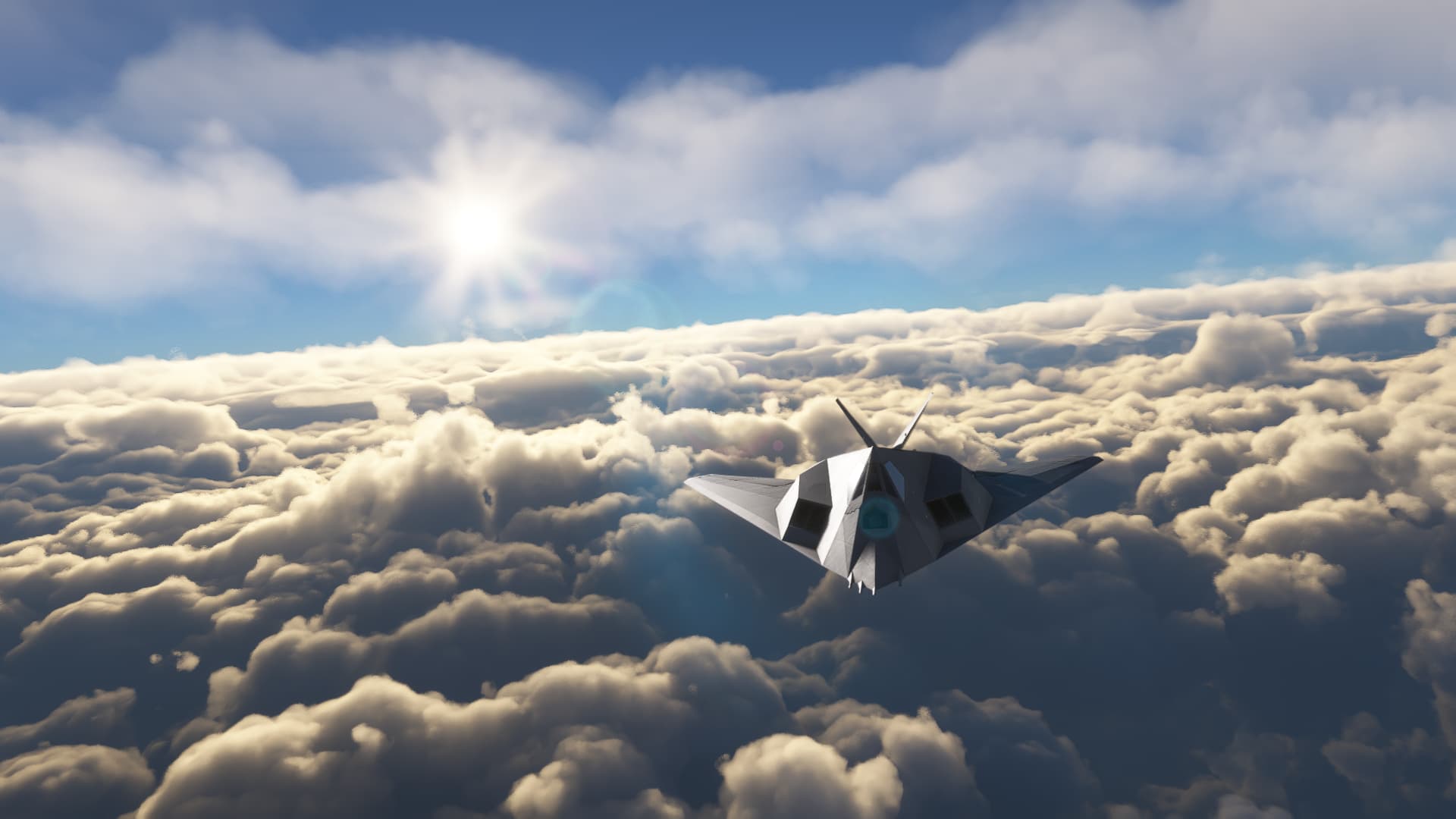
For this longest part I will be flying the F-117 Nighthawk from Aerial Simulations. I fondly remember flying this bird in the North Cape scenario in Microprose F-117 Stealth Fighter 2.0.

Time to climb this bird and get going. The weather aint pretty…

Getting into the Wobbly Gobblin isn’t that easy, you need to squat under that canopy.

After starting her up I had to ask my ground crew to un-chock the aircraft (interestingly, there is no parking brake on this aircraft) and I was ready do taxi.

While taxiing I noticed a rainbow in front of me, which only mean that there is a precipitation behind me.

I was assigned runway 16, while taxiing to the north end of the runway I could see great storm coming in.

I’ve increased my “walking pace” taxi speed to not be cought in that rain during take off.

As I turned into the wind I could see the wall of rain quickly approaching.

Taking a peek at the wind sock and my speed readout on the HUD (while being stationary) I could see wind speed of 25kts gusting to 30+.

Slamming the throttles to full MIL I thought to myself - “this is gonna be a bumpy ride”.

This aircraft needs a lot of room to take off - at 140kts you begin to lift the nose to 5° and at 160kts it should lift off. The head wind surely helped.

Right after take off, I retracted the gear and started right hand turn to avoid the soup.

If I waited few more minutes I would be wet. Lakselv in rain while I head north.

This storm cell surely moves fast.

I switch my waypoint from 0 to 1, 511nm to go. Lets only hope the weather at Savlbard will be more welcoming.

I try to climb out of this weather ASAP, normally best climb rate for this aircraft (according to the manual) is at 340 KIAS, which I’m obviously not producing currently…

More rainbows. ![]()

While climbing through the clouds I noticed ICING appeared on the caution panel.

I engaged all de-ice switches I could find. (the engine inlet wiper is not modelled on the exterior 3d model sadly)

As I gained speed, the inlet ramps started to close, reducing the aircraft RCS.

Still in the clouds I tried following the SOPs.

At around FL280 I emerged from the thick cloud layer.

With a beautiful sight unfolded before me.
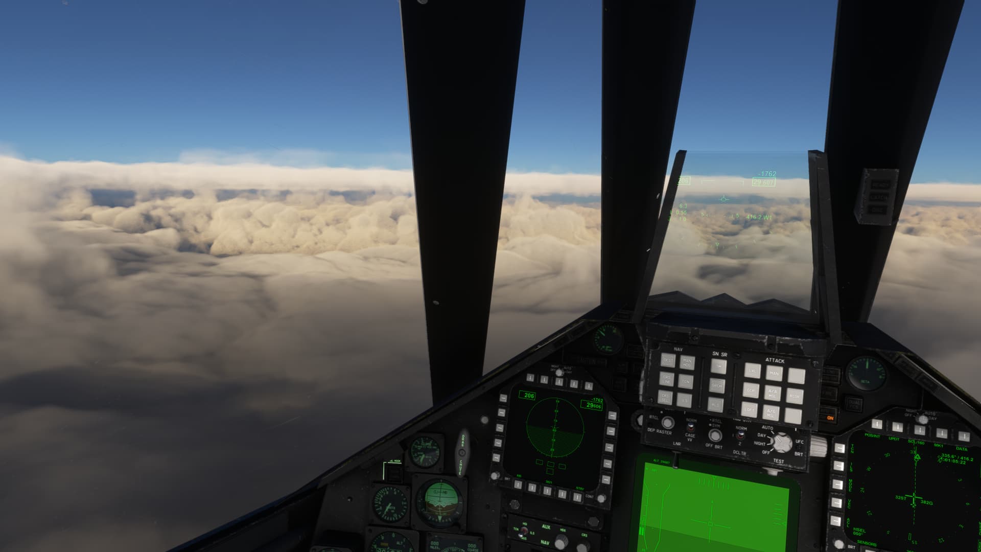
Some more beauty shots:


Still 100nm to go, I started preparing for the descend phase.

Also if you plan to use your radio, you better not forget to extend your UHF antennas.


Not far now, feet dry.

The frozen water below me only reminds me of the harsh climate here.

I turned left of course to avoid the weather, somehwere there is my destination airport. It doesn’t look too good.

I turned right into the clouds and used my IRADS display to locate the airport “visually” (used to display FLIR/DLIR image in real jet, which in these conditions wouldn’t do any good, but MSFS2020 implementation is using the synthetic view).

The view outside doesn’t look that promising though…

Thankfully, I break the cloud deck while descending right over the airport.

I “cheat” a little to check the wind (don’t remember if there was ATIS at this airport in MSFS). Looks like a strong wind from the north,

Which means this will be very challenging landing.This aircraft is the hardest one I had pleasure landing in MSFS. You need to keep your speed up, at 150KIAS and below your are doomed. Landing in calm weather is hard enough, doing this with the cross wind and turbulence will be traumatizing.

Since there is a cross wind I just turn around and set up for landing on runway 28.

I’m finding this building placement pretty odd here, but after the flight I checked Google Maps, there is a building there, maybe a bit shorter though.

I really struggle with all the wind gusts and keeping the centerline is a chore. Main priority is to keep the speed high enough to not stall - there is really small margin for error here (I wonder if this is true in real-life aircraft or only a limitation of the MSFS flight model). As soon as I touch down I lower the nose (you don’t aerobrake in the F-117) and quickly deplot the drag chute.

After bringing the aircraft to a stop, I turn around and taxi back to the apron.

I vacate the runway on the closest taxiway on the left.

I park, shutdown and exit the plane into a cold and windy weather of Svalbard.

But that’s not over of this journey, as I plan for one more joy flight ![]()

17 Likes
Great report! Congratulations on being the first!
You know of course that the first pilot opens a tab at the airport bar? ![]()
If I may ask, what did you fly with a FLIR?
8 Likes
Oh bummer, I left the tab open but I already have left the airport - more details soon ![]()
Maybe it’s my language barrier, but I don’t understand this question, could you elaborate more?
3 Likes
spectacular screenshots!
2 Likes
Oh, sorry. I have/had the impression that you flew something with a FLIR in it. Just was curious to hear more about it! ![]()
1 Like
That might have been a mistake! You do realise that two Australians are on their way? ![]()
8 Likes
Zanesville Ohio (KZZV) - Lake Simcoe, Ontario (CYLS) - La Grande Riviere, Quebec (CYGL). I flew these legs a couple of weeks ago but haven’t had much time to catch up with the AAR’s.
Departing Zanesville, I was originally intending to fly to Sudbury Ontario, but the weather was not co-operative. I was forced to pick my way through the extensive areas of precipitation and ended up a good bit east of my planned track. I decided to drop into Lake Simcoe airport, north of Toronto. I used to fly the King Air to Lake Simcoe fairly frequently. It was good to see the place again, even if it was just for a virtual visit.


Pushing on from Lake Simcoe airport, the weather had improved somewhat. Most of the flight had a layer of cloud below us but the visibility was sufficient for a visual approach at La Grande Riviere.


Next stop should be to Puvirnituk but I need to check that there is scenery for that airport in the base sim first.
12 Likes
I have to admit that the Eviation Alice is growing on me.
And I do rather like that livery.
2 Likes