Official 2019 Mudspike Christmas Flight - AAR thread

Leg #2 is in the books.

CYTZ (Billy Bishop Airfield) to CYQT (Thunder Bay) - a 512 nm jaunt across Lake Huron and Lake Superior.

2019-10-26%2012_40_22-Window

Weather looks pretty good for a Saturday (26 October 2019). I was able to do the flight in real-time as I tasked myself to do some housework during the quiet bits.

As above, the weather was looking good, save for headwinds that were not as strong as the previous leg. I would set out from CYZT at 11:12 local (16:15 UTC) and hit the YMS, YVV, SSM and YQT VOR Navaids at a crusing altitude to FL100. I was down from my anticipated altitude of FL120 as I would encounter more favourable winds at that altitude.

Bland scenery at Billy Bishop as I had not paid much attention to what was required for the Ortho4XP scenery. I did download some scenery for Thunder bay but, as you will see later, the missing libraries caused it to not really load properly. I’ll have that sorted for the next leg :slight_smile:

Wheels up - have to remember not to pull much and just let her fly off the runway.

From a distance, it looks pretty good … minus all the missing buildings that should be there :slight_smile:

CYYZ (Lester B. Peterson International Airport in the distance).

And the divide that shows between the Ortho4XP and default scenery.

Note the reflections of the scenery in the body of the airplane in that last screenshot. That was a surprise!

As I headed out over Lake Superior, I ran into a bit of a navigation issue. I mean, I have the GPS right there, so it is going to be hard for me to get lost, but the Nav radios started to give me weird readings. After passing the SSM VOR (if I am using the terminology wrong, please correct me), I had Nav 1 tuned to 112.20 (SSM Sault Ste Marie VOR - behind me) and Nav 2 tuned to 114.10 (YQT Thunder Bay VOR - ahead of me) . Take a look in the next screenshot to see if it makes sense.

My understanding is that I am on the 124° radial from the SSM VOR, showing on Nav 1 (green arrow) but Nav 2 is showing YQT off to my right. At this point, I realize from the map that I am not yet in range of YQT. Obviously I am pulling in a signal on Nav 2 (114.10) that is somewhere off to my right but I can not find it on a map.

This continues until I am well within the range indicated on the map. I suspect that this is somewhat realistic as there could be hills/mountains between me and YQT whereas with SSM, really, there is just open water between us. I end up running out of range of SSM, hunker down on my 300° course and either it comes up or I resort to the GPS :slight_smile:

2019-10-26%2015_50_31-Window

It finally comes it at about half the range of the circle on the map:

2019-10-26%2015_58_35-Window
2019-10-26%2015_59_17-Window

I thought that I might have been using the radios wrong but I had a lot of time to play around with them and, in the end, it worked out.

Well … it worked out to get my to Thunder Bay where the ATC took over…

For my first approach, everything was looking good. I was able to use the autopilot to reduce the workload while I adjusted course, descended at a reasonable rate and lines up my approach. Early in the approach I did get an alert on the TCAS…

I hear him on the radio with me, talking to Winnipeg Centre and I realize that I am going to have to keep an eye on him in case the AI tries to get us to land at the same time.

I follow the TCAS alerts all the way down to final and contacting the tower. In the previous picture, if you look at the Nav/Course HSI, you can see the TCAS yellow dot letting me know the rough location of this adversary competing for runway time. In addition, there is a passenger jet heavy with virtual travelers starting it;s takeoff roll as well. It’s a busy 10 minutes in this virtual airports life, so I can understand the difficulty in slotting us all in at the same time.

It’s at this point, just getting the odd glimpse of my adversary ahead of me (red circle) as I look over the sun shield, the two large airplanes taking off and the TCAS turning the ‘traffic’ indicator red that I decide to just go around. It’s just better for everyone, really :slight_smile:

I radio it in to the Tower and get punted back to Center for vectors. It takes some time, but at least the scenery is nice, even if the air is a little choppy for this little plane. Soon enough I am looking back down the approach.

And I am back on the apron, greeted by bleak scenery…

8 Likes

Yeah I am keeping an eye out for them on the next sale. I had them on my list a while ago but I was distracted with other aircraft :slight_smile:

1 Like

Fun looking plane there @Fridge :slight_smile:

3 Likes

Well even just the freeware ones. There’s a Toronto area or skyline or whatever + cyyz and a cytz. I forget who they’re by.

2 Likes

Woops. I did it again! I… :slight_smile:

1 Like

Wednesday Oct 23, 2019
Leg 4
Previous report | Next report

The most northern permanently inhabited place on earth. As far as we know, that is. CFS Alert, my destination.
I hope to see Santa Claus there, I have so many questions and I need answers. Mostly of the why variety.


Sorry for the shitty pictures last time, Victork2, here are some more shots of the big beautiful planes as I taxi out. Light conditions aren’t getting better for the next few months though!

However, I am being professional this time. I waited a few days for the mist to clear and the ceilings to rise to a few thousand feet at the destination.
I have been messing with the HSI and LOC, and found out why it didn’t work as I was expecting: while the HSI heading is magnetic, the localizer must be set to the true radial or runway direction.

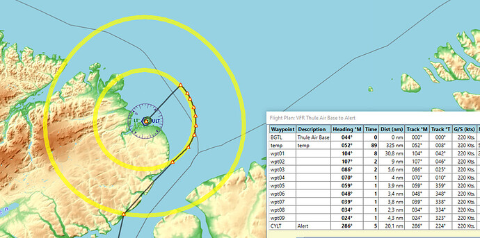
There are no approach charts available for CYLT, but I made my own: I will fly a GPS direct from Thule, then change my heading 40 nmi before the airport, picking up a 20 nmi DME arc around the ULT VOR station until I am on radial 093 magnetic. In this way, I can fly the approach completely over water / ice caps, thus safely evading terrain. Since the ceilings are above 3,000 feet, I should be able to land visually from finals. As for VNAV, terrain shouldn’t be above 9,000 feet anywhere in Nunavut (this region of Canada), so I descend to 10,000 feet at the 40 nm point, and start the slow descent to 2,500 feet at that point.


Waypoints are placed on the 20 nmi DME arc for visualising the flight path only.


A few rays of sunlight crest the horizon: although the sun itself stays out of our view, its light hits some particles high in the air, who decide to share a little of the light with us. This dull glow is still more sunlight than we will get for the next few weeks.

Take-off at 19:15 local time is uneventful, as is most of the trip.


A purple-ish night sky at 10 in the morning, and a cozily lit dark panel stuffed with classic six-packs and engine gauges.


The clouds get less dense up north, and we can see the coastline that we are following, as expected.

Actually flying that DME arc at 110 knots, all dirtied up, took a lot more patience than I thought. A few times, I got my hopes up and started to close in on the beacon when I thought I saw the airport, but of course, it was just some ships and an oil platform. 20 nmi is a long distance. Eventually, I did it though.


Ships off the coast of Alert? Isn’t this supposed to be an ice cap around this time of year? And is that a carrier?


On short final


Found a parking spot


Shutdown at 11:21 local time.
Next report

11 Likes

I know I’ve said it multiple times…but man I love that Do228 panel…it just feels so…right!!

5 Likes

Second leg is in the books for me.

Flight plan: ENVA SLU IO NRM DW1 SH USDD

I used realistic weather again, but this time I started the flight earlier instead of real time since I wanted to fly during the day and not have a night landing again (you will see how well that did go in a moment).

Edit: forgot to mention: this time I (mostly) didn’t use GPS, just VORs and NDBs (sadly I couldn’t figure out how to use NDBs properly…)

Good morning Norway!
Trondheim was pretty busy. That fuel truck refueling the Eclipse almost hit the light pole there.

Decent weather.

What’s that guy doing here?

Slightly foggy, but we will be above those clouds in no time.

Here we go!

Shortly after crossing the border to Sweden.

Busy airspace.

I don’t remember where this was, but it looks like an airbase.

This is somewhere over Finland. Everything was covered in clouds.

Entering Russian airspace.

I went feet wet twice, but nothing to see. The whole area was covered in a huge storm cell.

This is me, glad to be flying at FL420

And this is how it looked below the clouds. Sucks to be those Avanti pilots. The rain was coming in horizontally. Nice effects X-plane has, with the wind blowing the rain over the ground.

Uh-oh. Seems like I underestimated how short the days are. Again. This is going to be another night landing, isn’t it?

Yep, defintely sunset. Looks cool though.

Descending. And leaving the heavy rain behind. Just in time!

Dark again. Terrain looks kinda boring but I guess that’s what Siberia looks like.

Oh, there are humans down there after all.

Passing the Ural mountains, so by geographic definition I am leaving Europe now.

Salechard airport ahead (USDD)

Descending further. That terrain radar came in handy, telling me that I could trust the ATC this time. Pretty flat area, now that I am across the Ural.

The controller had a bad day and cancelled my approach, sending me on a big detour. 15 minutes until they finally let me land.

Almost there…

On final. Not exactly well aligned, I compensated for the crosswind, and then it suddenly got weaker. I also did the landing manually since there is no ILS here.

A tad high but OK

Landing was easy, and I got a nice parking spot. Not bad for stock scenery.

3 hours and 20 minutes of flight time. And I did it in real time because I can’t timewarp with those settings.
My fuel planning worked out perfectly. I had a bit more reserve included, because airport density is not that high in northern Russia.

Time for some vodka and some sleep.

10 Likes

What was not working for you? The Mudspike brain trust can probably get you squared away.

2 Likes

I’ll make a post about it today.

It’s great to see all the reports pouring in, I love this event.

I just left Alert and landed in … (check the event map in the ‘Users’ section)


I still haven’t seen the sun since Greenland.

4 Likes

This year I am not going to plan things out in any great detail. I do intend to take in some of the amazing scenery I have picked up, and do some sight seeing. Time might become an issue, and if it looks like I won’t be able to finish before the middle of December, then I might switch to a faster airplane…

So, here we are on the Atlantic Aviation ramp at Austin Bergstrom Intl (KAUS). My goal for today is to make it out of Texas. The DHC-1 Chipmunk by Khamsin Studio…

Taxiing out to runway 17L…

Annnnnnd I’m off!

Over downtown Austin.

Approaching Lake Travis.

Some time later… Lake Buchanon and the smaller Ink’s Lake.

The town of Brady and the Brady Resevoir …

A quick fuel check… still plenty left.

San Angelo

Pushing on past Midland, TX…

About 30 minutes out from Roswell, NM, fuel is getting a little tight. I should land there with about 30 minutes of fuel left. Not IFR mins, but this is a VFR only aircraft anyway, so it’s all good.

A welcome sight! Roswell (KROW)…

Turning onto a short final,

Shut down at last.

It will be interesting to see how far I can get tomorrow. I’m hoping to at least make it to Arizona.

10 Likes

Roswell to Carrizozo, New Mexico.

This morning I flew the venerable Chippy all the way across New Mexico, but decided I should do it again after fixing a big scenery issue. For this trip, I decided to play around with Ortho scenery by Forkboy. It isn’t the most detailed Ortho out there but his packages are far better than using stock scenery. The problem I was having was the amount of vegetation was far to high even in the desert areas.

I picked up Xtreme Trees West at the org store and it made such a difference, I wanted to see New Mexico again, a little closer to how it should look…

So, for the second time today, I head out from Roswell. Looking out to the West, we can see the Capitan Mountains on the horizon. The vegetation is looking a lot more believable!

The mountains don’t seem to be getting any closer…

We get there eventually though…

The Chipmunk is a great airplane for sightseeing.

As we get to the western end of the Capitan Mountains, the terrain flattens out again. If we were to head South down the wide valley, we would end up over the White Sands Missile Range, but we won’t be seeing that on this trip.

The town of Carrizozo comes into sight…

Final…

Shut down on the ramp. Someone has done a nice job modeling the airport here.

So, not as far tonight as I would have liked, but I am quite pleased with the scenery now. Tomorrow I will try to get as far as Flagstaff Arizona, although I might stop for lunch in Winslow, maybe stand on a corner and keep an eye out for a girl driving a flatbed Ford. :rofl:

7 Likes

But be sure to take it easy. :smiley:

4 Likes

They have a whole thing there, with a mural and everything.

They advertise it for 50+ miles in either direction on I-40. And I-8. And I-10.

3 Likes

If I ever get back there, I will have to check it out.

1 Like
4 Likes

I… I can’t decide if that is cool or incredibly sad.

4 Likes

An uneventful leg from Carrizozo. I just puttered along taking in the view. Crossed the border into Arizona, eventually flying over Winslow. I still had plenty of fuel left to press on to Flagstaff.

Departing Carrizozo…


Taking in the view. I don’t know why I held out in getting ortho scenery for so long. I think OrbX spoiled me with their True Earth products. Regular texture tiles just don’t cut it for me anymore. I can see an additional large capacity HDD is in my future…
Winslow…that famous corner is down there somewhere… A quick check of the fuel gauge and we press on towards Flagstaff.

Flying from Winslow towards Flagstaff, it is pretty much impossible to miss the famous Meteor Crater…

The terrain gets a little greener and mountainous as we approach Flagstaff.
Base to final.
Safely shut down.

I don’t think I will be able to continue before Friday, but the Grand Canyon beckons…

14 Likes

Stunning shots! The natural beauty of northern Arizona never fails to surprise and delight me, and that scenery and your pics have captured it really well.

1 Like