I’ve been told that Lone Star is to Texans as Foster is to Aussies. My family all drinks Shiner.
3 Likes
And now a return to your regularly scheduled madness.
Back when I decided to try this, I knew that at some point I was going to have to haul some chili.
That point has come.
I have also noticed that I seem to have developed a habit of flying maiden voyages, over ludicrous distances, with little or no planning, based mostly on data that I’ve found on the Internet.
I am not sure that this habit is entirely without its consequences…
Leg 14: Whenuapai Air Base, RNZAF, Auckland, New Zealand (NZWP) TO Sydney/Kingsford Smith Airport, New South Wales, Australia (YSSY)…almost.
Ok, here we go. I’ve got exactly three months to get a little more than halfway around the world.
Next stop, Australia.

At 1158NM, not even close to my longest leg. But I wanted to do it fast.
If I had a nice steam gaugey 747 or even a 72, this would be easy, but nothing in my hangar really suits.
Enter the Starfighter.

Yes, I know that the 104 is not exactly known for its long legs. But, depending on the source, the Max Ferry range for the Zipper runs from 1100-2000NM, with most of figures running about 1600.
Well, only one way to find out. This might be my Hail Mary(est) flight yet.
Isn’t it always? ![]()
As a little aside, as you can see the weather in Auckland is deceptively nice. Once again, when the clouds loaded on the globe in the map screen, I was hopeful.

But again it didn’t work in sim.
Interestingly, when I took the 104 out for a shakedown flight yesterday (See? I ain’t so dumb) I had the same issue, but noticed an interesting cloud dispersion over Wellington.

So Live weather seems to work in some places for me, but not all.
Weird.
Anyway, well behaved (at least for a leg) REX to the rescue.
Depending on your definition. ![]()

I really need to start memorizing the location of the light rheostats.
Or start taking off in the daylight!

Started to see some breaks in the clouds as I was taxiing out to the runway. Hope the weather is better when I get to Sydney. I’m not going to have a lot of gas for fooling around when I get there.

Lined up and ready to go. Is it me or does she look like she wants to jump into the sky?

I really debated using the burner for takeoff. The jet was heavy and the runway not all that long. But using the juice was really going to suck down the dead dinosaurs.
I decided to use it just to get airborne.

Hmmm, did I sign that life insurance policy before I left? ![]()

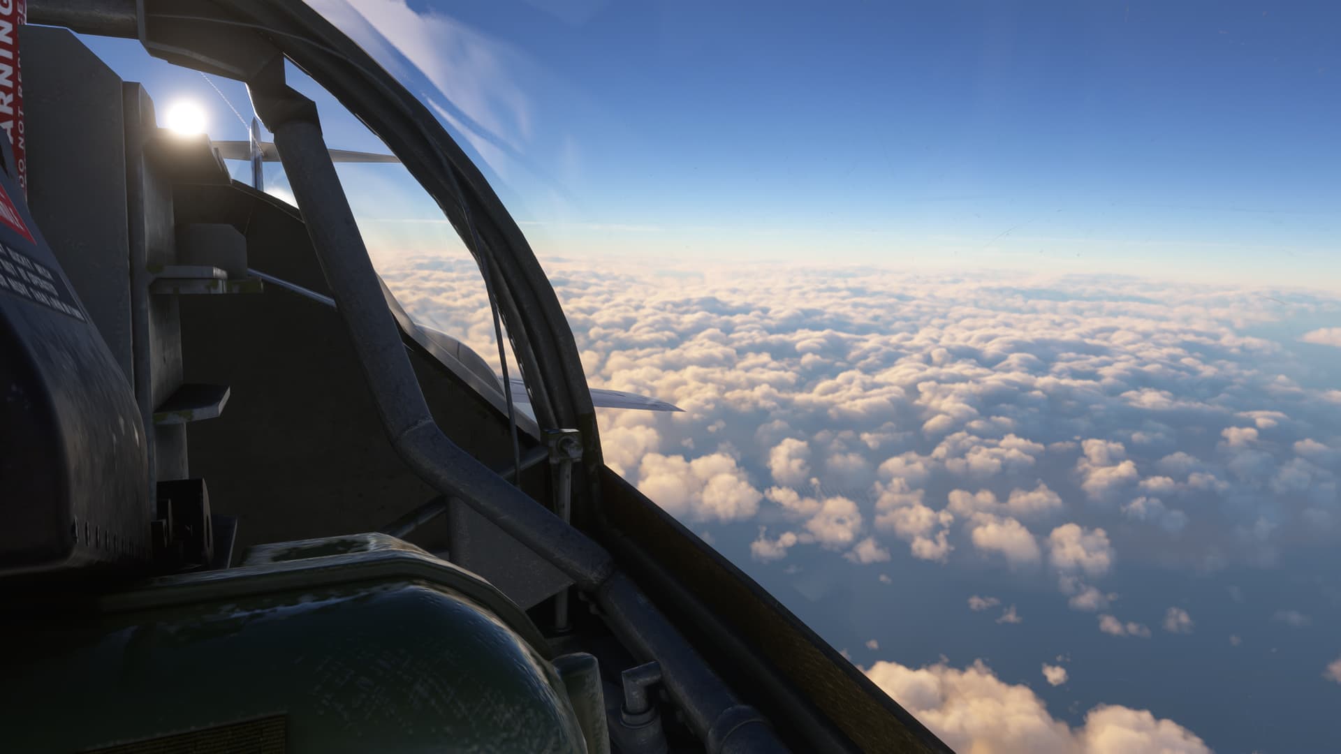
Clean and back in Mil Power, I burst through the clouds.

Man, this thing is pretty!
And slicker than snot on a doorknob.

Climbing out, I burn through the drops in a heartbeat.
Time to select 'em for return to the taxpayers.

And didn’t even vapor lock my engine. Not bad for my first time! ![]()

I level off at my cruise altitude of FL360. Having no other numbers to plan with, I used the SSW included Bingo charts.
Part of the problem though, is that the Machmeter portion of the Airspeed Indicator seems to be obscured. I’m pretty sure that the left half of that window should be open.
So I can estimate my required 0.85M (provided the gauge is operating properly…I’ve seen those that don’t), but I can’t be super accurate about it.

Tips are done. Holy cow does this thing suck gas!


Tips selected to jettison…

And bye, bye tanks!
So originally I was pretty happy when I saw this. Looks like about 30-40% of the distance down. Up at cruise altitude, all external drag gone, full bag of gas.

Can you spot my mistake?

I know that it’s not a fair question, though you all likely know about as much about the 104 as I do; if not more.
But it goes something like this, and I think these numbers are right(ish).
Originally, my math went like this:
-5,500lbs Internal fuel
-1,100lbs in the tips
-1,100lbs in the pylons
So, very roughly, about 2,200lbs of the 7,700lbs (about 28%) had gotten me about 30+% of the way, including the climbout.
But those needles are doubles.
So,
-5,500lbs Internal fuel
-2,200lbs in the tips
-2,200lbs in the pylons
In other words, about 4,400lbs of the 9,900lbs (about 45%) had gotten me only 30+% of the way…thankfully including the climbout.
Now things were a lot less certain.

It’s difficult to say how accurate these numbers were. The wind aloft didn’t seem to be affecting me much. I double checked the Bingo charts.
In retrospect, I may have used these charts incorrectly. Originally, I had used the highest fuel box that I could find, 3000lbs of fuel. I had also seen the smaller box beneath and to the right that reads “With over 3000lbs of fuel…”, but the print was so small that I misread the 30,000ft for 35,000ft, the same value as the rest of the chart.
I’m not certain what difference that 5,000ft meant if you had 3,100lbs, or 3,200, or even more. But the AB takeoff and the funky Machmeter and the chart error combined might just be enough to send me for a swim!

What seems like a short time later, my internal goes below 1,000lbs.
The Fuel Low Level caution comes on.

341NM to Sydney.

The ocean suddenly looks very big.

Time to start looking over this.

An uncomfortable number of minutes later…
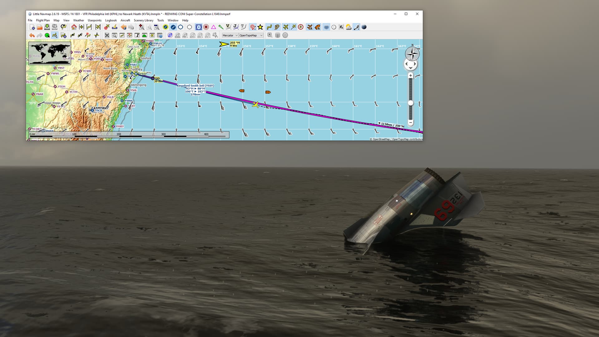
There she goes. I’m a glider (meteor might be a better description in this thing).
“Mayday, Mayday, Mayday! Air Force 132 is going down 300 miles East of Sydney VORTAC!”

300NM out.

This glide angle is enough to shorten your life span.

Down into the cloud deck. Don’t know what the bottoms are.

Broke out into rain and low ceilings underneath. It’s going to be a long night in the raft! ![]()

Bleeding off my airspeed. Tried to pop the canopy, but it’s inop.
There’s a tag that says, “Courtesy of MM Enterprises”. ![]()

Lower.

Lower.

Down.
I wonder how Dodge and Landon are going to fare? (Extra points for the reference)

And there she is, 278NM from Sydney. There are a couple of ships nearby. Hopefully, they got my Mayday.
It’s hard to say exactly how accurate this all went. There were certainly a number of things that didn’t go exactly according to the Bingo profile as I understand it. It’s also possible that the wildly varying available range figures are hiding some mystery in model or configuration. But it’s hard to escape the impression that the Zipper in MSFS might not just zip through the juice a bit quicker than normal. ![]()
Still, it was a swing for the fences, that’s for sure!
Anyway, something to ponder while I try to figure out why this Sea Dye smells like meat tenderizer.

11 Likes
When I first went to NAS Beeville in south Texas, I ordered a Lone Star. You know 'cause, Texas.
I swear you could hear the needle scratch across the record player.
And I’m not even sure there was a record player there. ![]()
3 Likes
Nice to have you stop by at my stomping ground! ![]()
2 Likes
It’s beautiful country!
2 Likes
Not that Mona AB would not be a nice place to stay but it was definitely not my intended destination for the last leg.
It was Sligo. So let’s get to Sligo finally, shall we?
After the last flight, I amended the Bonanza’s checklist:
- Take full fuel.
- Check, the tanks are full indeed.
- …
I also got rid of the girl in the right seat. More weight equals higher consumption you know…

A beautiful morning.


On my way to Ireland, here heading towards DUB VOR. With some 40nm range I was about to receive its signal.


Ireland!

Dublin International on my 9 o’clock.

From the DUB VOR, the plan was to track radial 302 until reception of the Sligo’s NDB station. Here the ADF needle came alive.


Sligo is behind that little hill. I like quite a bit the landscape I have to say.


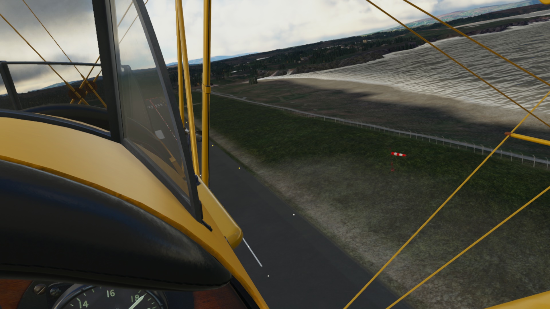
Checking the windsock. It looks like this almost perfect 90 degrees crosswind will make an interesting landing.


In the end the approach and landing was not a big deal.


A little later than expected but who cares. Another tick mark in my itinerary list.


9 Likes
After the uneventful last flight I felt like having some little adventure. The newly acquired Tiger Moth was a good excuse as well to make a short hop of some 46nm from Sligo to Donegal.
A little windy today. And across the runway as well. Did not feel like flying the Moth suddenly, to be honest…
Though these guys looked convincing enough to set off for the trip. They also came to make sure I do leave.

With that wind and that airplane, the only sensible way to take off safely (?) was this:

Well, it worked well so slán mhaith and see you some other time!

On the way, I was checking some new VR goodies I got from flightsimulator.me (payware), like the PDF reader, LittleNavMap toolbar and enhanced VFR map. Nice things to have for just 5 euro.

It was windy. Very windy. You can’t really see it from the screenshots but the Moth was all over the place. Other than that, it looked like a nice VFR flight untill the moment…


…it stopped looking so.

Let’s take a moment to appreciate that the Moth does not have an artificial horizon.

So the rest of the trip turned into trying to stay away from weather, low flight, checking the map vis-a-vis the land features (or what remained visible) and hoping the Moth’s top speed is higher than the winds aloft.


And then… all of a sudden…


Wind did not get any weaker but at least it was aligned with the runway.
With the unorthodox departure at Sligo, I thought it would look nice to couple it with an unorthodox arrival to Donegal - like an helicopter approach directly to the apron ![]()

Down!

OK, it took a couple of shots as at certain speed the Moth just dropped out of the sky but in the end, I kind of made it.
Next destination? Shetlands!

11 Likes
Great report!
Now you’re ready for when the Harrier comes out! ![]()
2 Likes
Just not to leave your question unanswered…
No ![]()
I do not have usually too much time simming so I just glance over the map (LittleNavMap), memorize some frequencies, distances and headings (I fly in VR and do not want to be removing the headset every five minutes; that’s why I like the new LNM integration to VR) and then hope I’d get to the destination.
It works more often than it does not ![]()
2 Likes
Well that’s at least three times as much preparation as I do.
So I salute your thoroughness!![]()
![]()
1 Like
I … thought that was how pilots did it? It isn’t? ![]()
I started my journey much later than I hoped - stupid work paying for my flight sim addiction! And it feels like I am hiking to my destination, given the speed I am going.
For my Christmas flights I am planning on using, primarily, X-Plane 12 - mainly because I trust the helicopter flight models better than what MFS currently offers. I may switch to MFS, and back again, at any time. The second reason is because it’s new and shiny ![]()
For my aircraft, I am going with the SA 3125B Lama helicopter from Phillip Ubben and Khamsin on the X-Plane Store. This little beast looks simple and interesting to fly. The Lama has one navigation radio, which is good, but no nice and reliable GPS receiver - which is what I usually rely on. I plan on flying VFR but, depending on the communications options in X-Plane, it may vary. I may also hop out to another module if I find that I am falling too far behind on the schedule.
I will also be doing real weather which may not be the best choice. Winter is coming and I have to keep an eye on hurricanes coming up the east coast of the US, icing conditions that may catch up with me as I fly down from Canada and whatever Mother Nature decides to push in front of my flight plan. This may also cause me to swap away from the SA 315B as weather/night flying may make itself known enough to interfere with me arriving at my destination sometime in 2022.
Leg 1: CYFC Fredericton, NB - CYSJ Saint John, NB
My first leg is from my home airfield down to Saint John on the southern coast of NB. In between the two is one of the largest land training areas in NATO. CFB Gagetown is a significant presence on the map and, as far as I remember, there are a number of flight restrictions that keep civilian and commercial aircraft away from artillery firing drills, army maneuvers and, sometimes, CF-188s dropping ordinance in support or ground training and/or CH-146 Griffons doing helicopter training.
Taking this into account, you either have to go around west or east. I chose east to stick with the river as a guide.
[will post flight plan screenshot later]
The other benefit for this are two VOR navigation beacons (YFC and YSJ) that I could use for navigation. Since I know the area and had a safe river, if somewhat large) river to follow, it would provide a good opportunity to play with the OBS instrument on the SA 315B and get used to it. No GPS was also a concern, but you make do.
I don’t have a lot of pictures for this flight (ie: any pictures) because I spent enough time setting the controllers up in X-Plane that I was getting a little frustrated and just wanted to get some flying in.
Of interest in this flight was some ‘wonky’ engine noises that I ran into a few dozen nautical miles from CYSJ. The best way that I can describe it is ‘engine surging’ and I have no idea what I was doing that was creating the condition. It boiled down to the engine surging and dropping back again, causing the tail rotor to over and then under perform. It looked like pilot induced yaw oscillations but was caused by the engine governor freaking out for a bit. I was concerned enough to start circling down to land on a field somewhere.
After a while the surging went away and I was able to continue. I noted that I had turned the engine starter off after engine start and according to that I have read, it says on the whole time. I encountered it on more time on this leg.
Leg 2: CYSJ Saint John, NB - CCS3 Saint Andrew, NB
Originally, I had planned on heading to CCN2 Grand Manan Island but travelling a significant distance over water with no landmarks was worrying me. I could make use of the YSJ beacon, since I wasn’t going to leave it’s coverage on this leg.
[will post flight plan screenshot later]
I planned on trying out the VFR ATC comms in X-Plane 12 but I ended up futzing it up and dialing up the approach frequency to Saint Andrew was a challenge. I figured out on the next leg that the trimmer is functional in the Lama - which makes dealing with anything requiring a third hand easier.
I had my first crash of X-Plane on approach to Saint Andrews. I feel like it was about to switch from an en-route pattern to a VFR approach pattern and it dumped me out. Oh well. I was close enough that I assumed that I landed ![]() .
.
No pictures for this flight either. ![]()
No engine surging this time and I left the starter switch on. But this issue came up again on a following leg.
8 Likes
It’s finally time for me to get things rolling with my Christmas journey… This year I am starting at a small grass strip that is maybe a mile and a half as the crow flies from my house. For this leg I flew the FlyInside Bell 47.

Here we go…


Dropping in at my house. The trees are about twice as tall as they should be, but it is a pretty good approximation.

Time to head to the real launch point of the trip, Austin Executive Airport (KEDC)… For the most part I followed the route of my normal commute.


Approaching KEDC. The runway here is 6000Ft long, but the displaced threshold robs you of a good 500ft. Not a problem today in the Bell though.
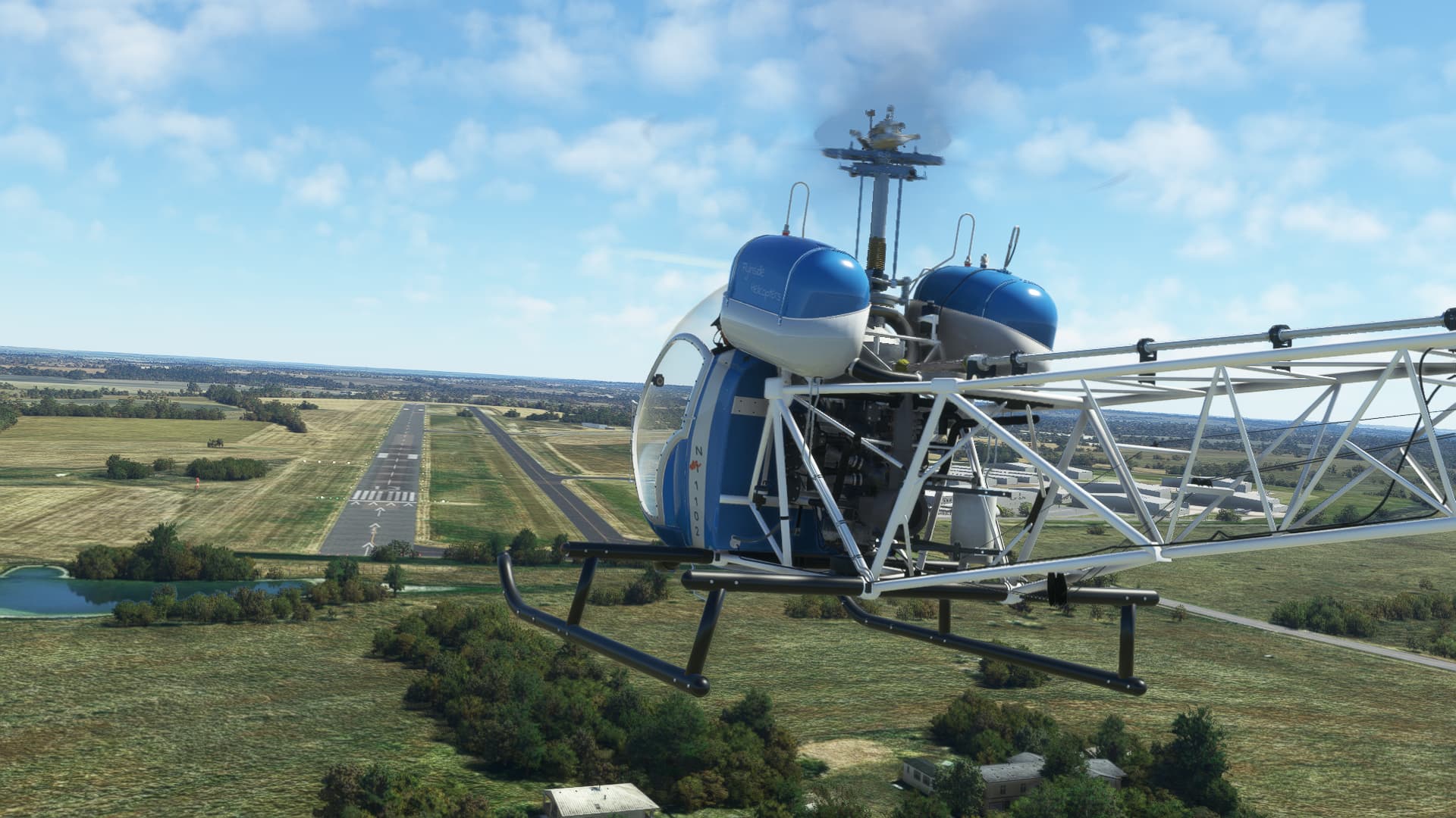
Touched down on the helipad.

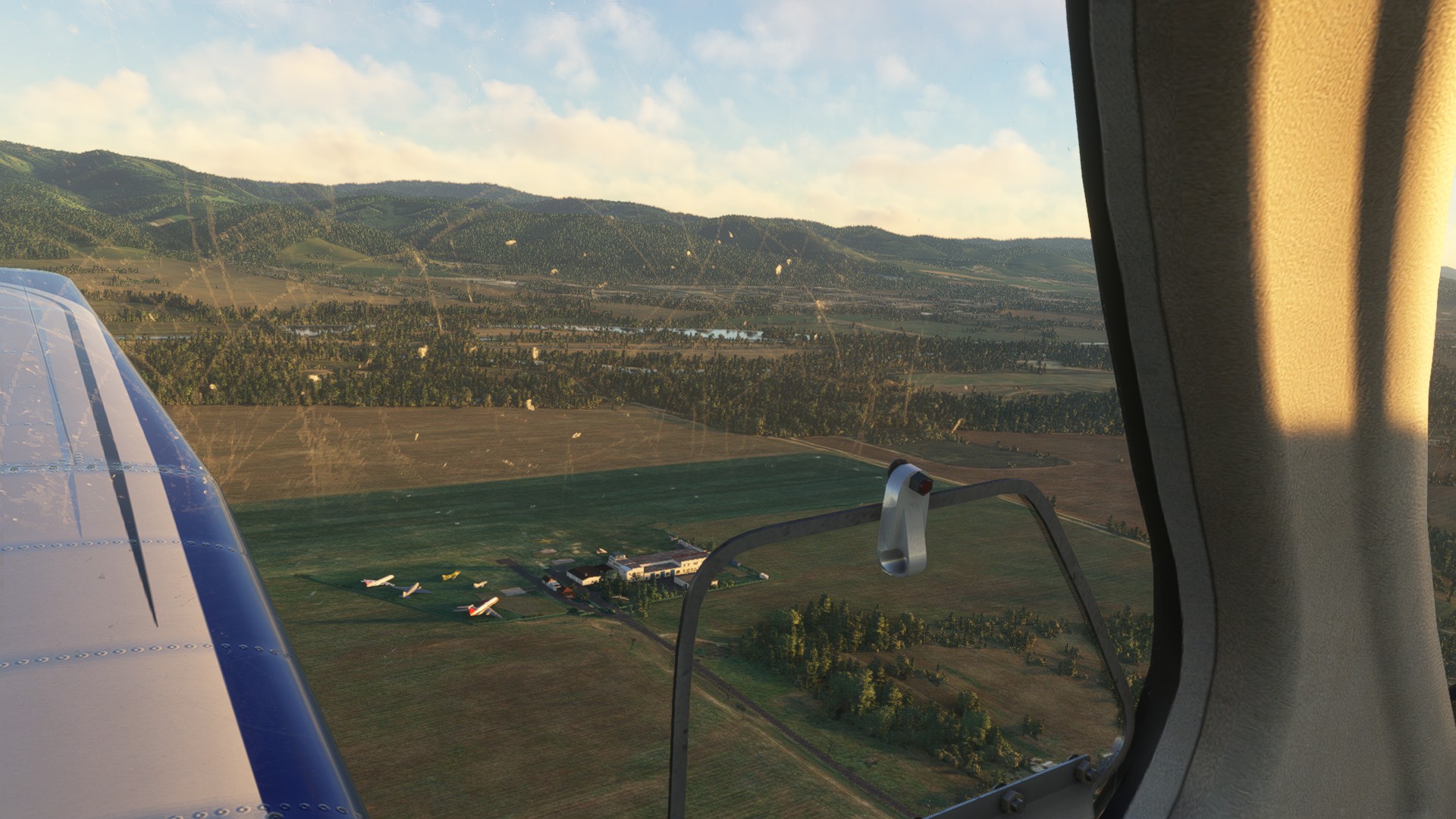
Looking over at the canopy. They park jets up to the size of the Challenger under there which gives some relief from the Texas sun…it does amplify the noise of the APU though… ![]() . This is a really nice freeware rendition of KEDC.
. This is a really nice freeware rendition of KEDC. ![]()

Shut down and ready to hop into something a little faster for the next leg.

11 Likes
fine adventures there boys!
great to see some helos. but @Fridge it didnt happen when you have no pictures. at least some pics for illustration ![]()
I either did not spend that much time over a planning board. usually my first flight(s) is some kind of test flight to see what I can expect from the bird … not like you @Deacon211 straight to the unknown :buzzlightyear: ![]()
![]()
here my sightseeing ride along the Chilean cost. the weather is surprisingly stable.
Calita Andrade SCIH


crossing the waters

Melinka SCMK

crossing (scud running) the waters again

and here I just left the AP to do its things for too long ![]() ended up in Queilen SCQX then and not the originally planned Quellon SCON
ended up in Queilen SCQX then and not the originally planned Quellon SCON

10 Likes
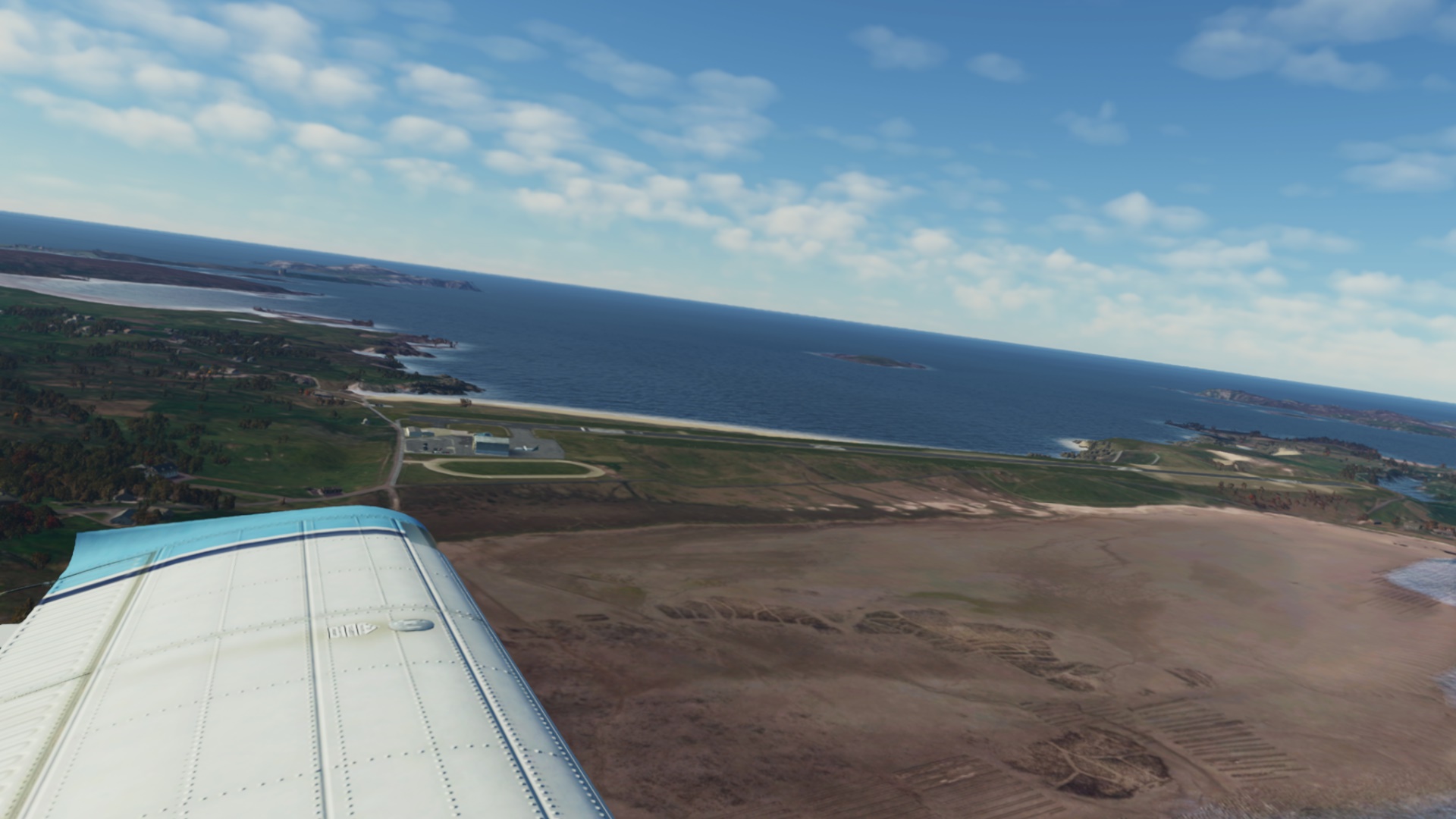
This was a leg I was looking forward to: Donegal to Out Skerries in Shetlands. Both fields are default handcrafted sceneries that looked really nice.
I was looking at something “radial” but in the end decided to pick the TB-21 which I have not flown for ages. It is a nice aircraft from Lionheart Creations. Its landing distance over a 50ft obstacle is some 1770ft. This will become important later as the runway in Out Skerries is 1204ft long. Well I guess I just need to make sure not to be landing over a 50ft obstacle, right? The TB-21 landing roll is 925ft so it should be OKish and if the need be, I will do some aerodynamic braking by opening the doors.
On the way I am also checking the recently released FS Live Traffic Liveries, a freeware addon that brings live traffic from FlightRadar24 to MSFS (think of it as an alternative to AIG). Not that I was expecting much traffic here but it was nice to see a static aircraft on the apron ![]()

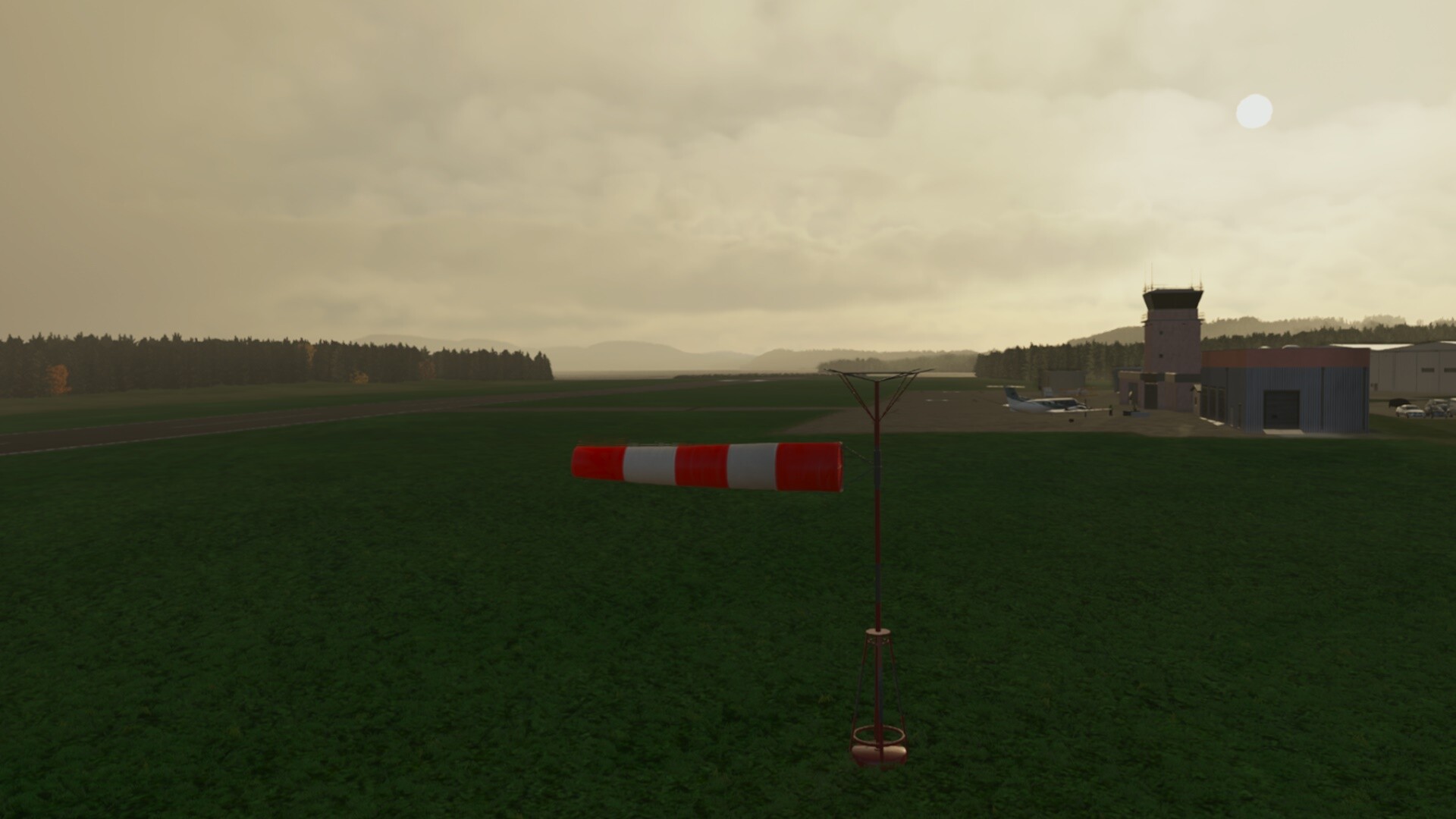
It was very windy on my arrival last time and it was very windy on my departure as well. Only now the wind was perpendicular to the runway.

Even with full right rudder and aileron to the wind my first t/o attempt ended like this.

This should help a little…

It didn’t ![]()

Snap! ![]()

Well… I made it in the end and departed towards the Tiree VOR, the first out of three on my way to Out Skerries.

Cruising…

Isle of Tiree.

The TB-21 is a little unusual French design.


Isle of Skye. With Portree in the distance. I did some memorable hiking over there and had the best mackerel in my life in one of the restaurants in the port. Yes, it was after a long tiring wet day.

Isle of Lewis and some weather ahead.


I was on autopilot so not a big deal getting into the clouds. Only the OAT could be a bit higher.


Leaving Scotland behind. I have fond memories trekking out there. I think I discovered a new dimension of “rain” and “wet” in general. At times, it was raining horizontally.

Over Orkneys towards Shetlands.


This is Sumburgh. From there I needed to track radial 27 to my destination. Fortunately the weather cleared (a bit). The wind did not. But I did not know that yet.


Out Skerries - my destination. Overhead join to check the windsock.


Which looked more-or-less aligned with the runway but almost blown away by the wind. This is my first landing attempt. Had problems to see the runway.

Yep, here it is.

Not looking good…

You can see that my landings in heavy wind and light aircraft are consistent with my take offs in similar conditions.

This was not my second attempt. Not even the third one. Anyway, I managed to get it down. No wonder the guys having coffee in those chairs ran away. I wonder why were they sitting there in the first place.

OK, debriefing:
As for the TB-21, I liked it. However, I could not get rid of the lady in the right seat as much as I could not get the pilot to be seen in the left seat. And I played with the W&B sheet to set different weights to both of them.
The TB-21 has two tanks which need to be switched during the flight (pretty much in the same way as in a Piper). However, the fuel was drawn from both tanks simultaneously until I touched the fuel tank switch. Only then the respective tank was used to feed the engine.
As for the departure - yes, too much cross wind, too light aircraft with the x-wind out of its limits.
The arrival was a different matter. With the wind aligned to a high degree with the runway I did not expect problems. Though the TB-21 got into heavy turbulence right over the edge of that cliff on the approach path and then again right over the runway threshold (there is also a ridge there). Remember the issue with the runway length and the landing distance? I was aiming therefore at the runway threshold. To me it seems that with that wind strength and direction, MSFS generated some ortho-induced turbulence. If that was the case, then well done.
When approaching from higher altitude with more aggressive descent profile, I avoided the turbulence but landed long and overran the runway.
Ugh. Next time… yeah you know.

8 Likes
Amazing report! That’s got to be a tough needle to thread.
2 Likes
To be fair, there’s been a lot of reports that with SU10, the turbulence and crosswinds especially seem to be way overdone, so there’s that.
That TB-21 is gorgeous - I may have to look at picking it up.
2 Likes
Yeah. I hear ya. I almost re-did them ![]()
Leg 3: CCS3 St. Stephen, NB to KBHB Hancock/Bar Harbour, Maine
Crossed the border into the US on this flight. Weather was quite good. I can’t remember if I was following an IFR flight plan for this one but looking at the track on LNM, and I apparently didn’t take into account the magnetic declination…

The Lama and XP12 are doing pretty well in VR. I am having some pauses (HP Reverb Gen2, 3080TI) when I first get in but after a few minutes they seem to straighten out.

The default scenery is fairly good, all things considered. It will be interesting to see how 3rd parties (or the OrthoXP app) can adapt to some of the new features. I think that coastlines are an issue with OrthoXP at the moment? Maybe.

Without an autopilot, it’s a little hard to get an external shot.

So it was an IFR flight, according to this next picture. They must not have been paying that much attention to me?

I asked for 2000 feet but they just didn’t want to let me actually go down to that level after filing for 4000 feet.

On the ground at KBHB. I managed to mess up the circuit that the ATC directed me toward.

How are you supposed to enter the downwind circuit for, say, runway 12 with right turns? I overflew the airfield at 2000 ft on whatever heading I was doing, and then attempted to pick up the downwind leg for runway 12 from there while making right turns. From the initial entry instructions, the ATC went quiet until I crossed the runway threshold for landing. The ATC menu was blank, so I couldn’t announce my position or anything. But I did get a nice window pop up blocking my VR view that I had violated ATC instructions and that they were mad at me. ![]()
9 Likes
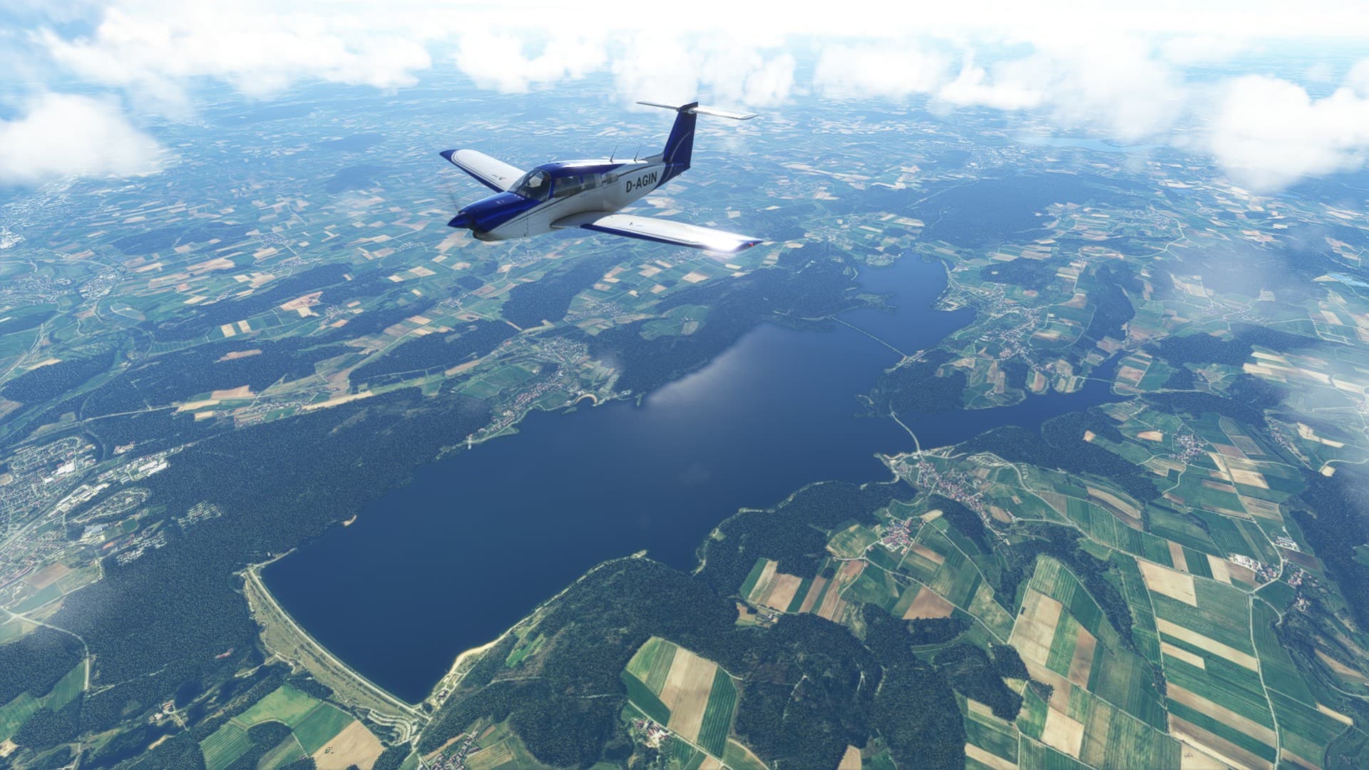
I finally started my journey as well, and the first leg was already pretty fun. Here is the AAR:
As usually I fly with real time and real weather, and I don’t use the ingame map or anything else that I wouldn’t have in the plane, except LittleNavMap on a second screen so I have a proper map (without the plane position of course).
I started at my home airport EDSB, sadly there is still no scenery for it but I am told that Aerosoft is working on one.
My chosen ride was the Piper Turbo Arrow IV. I really like that plane. You just have to stay out of the weather because there is no anti-icing equipment in it.

Here we go!

I flew this VFR but I like radio navigation so I used VORs/DMEs.
A lovely day for flying.

Schwäbisch Hall (EDTY)

The Altmühlsee, a reservoir lake with rich wildlife.

Further along the river Muhr this is the Brombachsee, another reservoir lake.
Some thicker clouds ahead. I cruised at 11,000ft so I considered dropping down a bit, the temperature was a bit below 0°C so only dry is good.

Just before Regensburg I descended to 9000ft and dodged those clouds.

I found a hole between them though, and pushed through.

Regensburg.
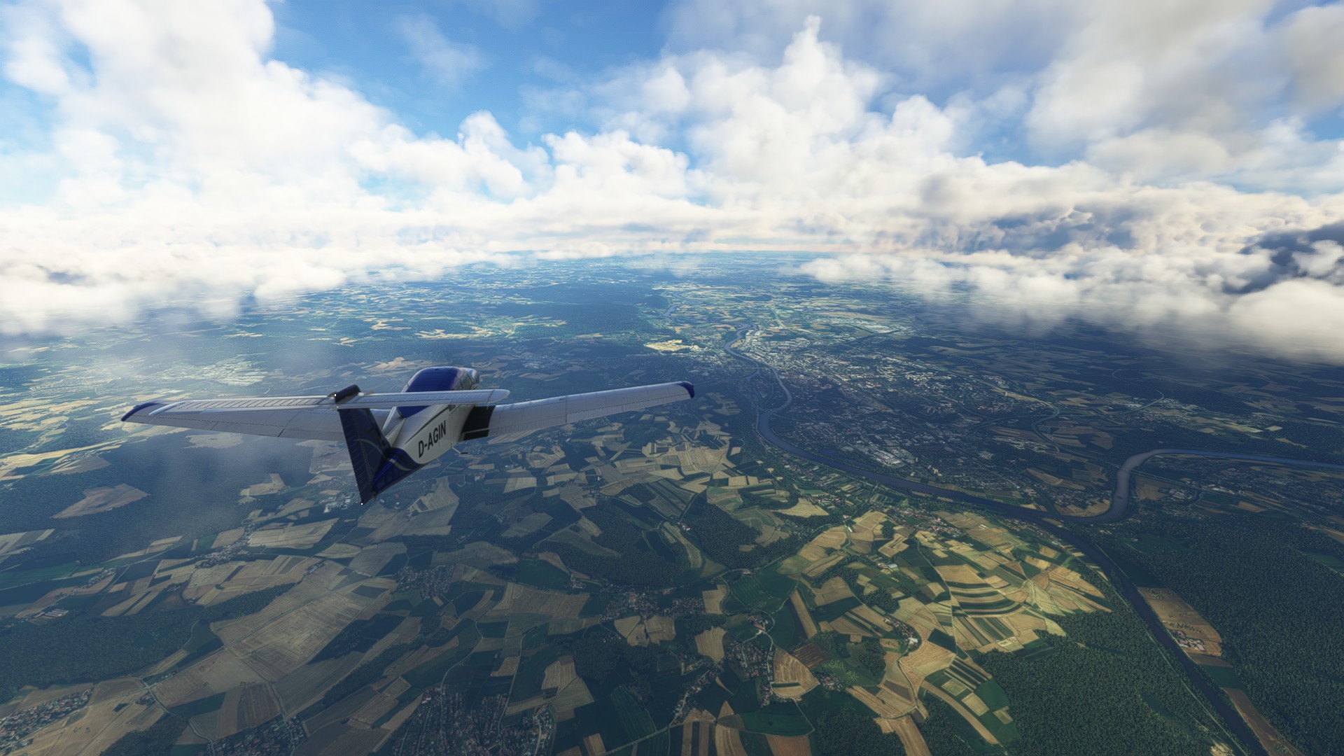
The VOR wasn’t working here for some reason (the DME did though), so I looked down and followed the river Danube for a bit.

Flying into Czechia near Zwiesel.

The nuclear powerplant in Temelin makes a great landmark.

Yet another nuclear power plant further east, Dukovany. Hidden behind those clouds is Namest (LKNA).

My next waypoint (and also the location of one of my divert fields) was Brno, but it was hidden beneath those clouds.

Near the Slovak border, beautiful hilly terrain here.

Descending, a bit north of Trencin.

My destination for today is Dubnica/Slavnica (LZDB), @NEVO’s home field I am told. I found a nice freeware scenery of it on Flightsim.to

There is a small aviation museum with a few planes there.
On final. Not too bad considering that I haven’t flown the plane in a while and this is my first time using a yoke (Saitek Pro Flight Yoke System that I borrowed from my brother. Definitely feels different to the joysticks that I usually use. Especially since I placed the throttle quadrant to my right.)

Parked. This was fun. Time for a Borovicka (I have no clue how that tastes but I read that it is Slovakia’s national beverage and this is my first time in Slovakia, so I will definitely try it) and to look at some planes in the museum. A few are modeled: Mig-15, Mig-21, Su-22, Tu-134, IL-14 and Li-2

The track basically looked like planned, I am pretty happy about it.
The plan was: EDSB KRH DKB UNKUL RDG LKDN OKF BNO LZDB
406nm, which (thanks to a tailwind that helped me reach ground speeds of up to 182 knots) I covered in 2 hours and 30 minutes.

Next up: Fly to Prague in the Piper, load the 50kg of gingerbread that I brought into the Citation Longitude and get going toward the northwest. Thanks for reading!
11 Likes
KEDC-KCLT
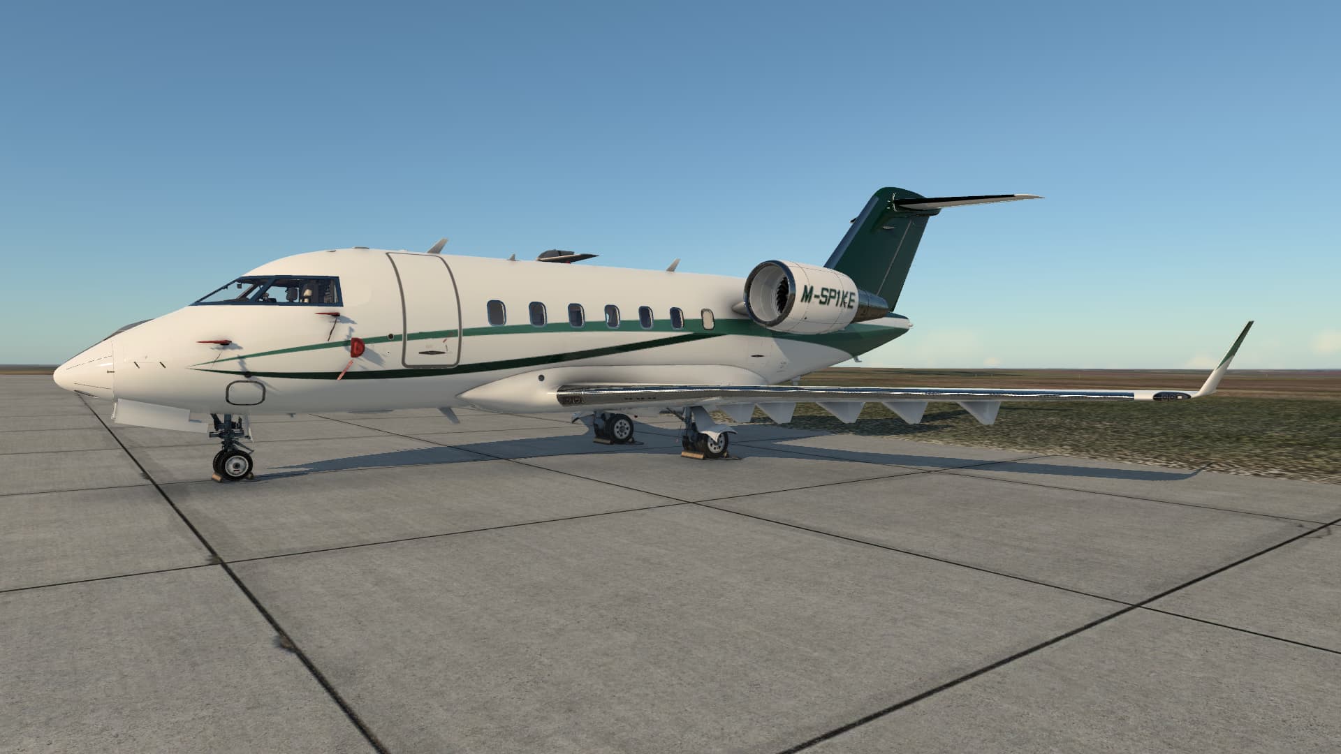
Seeing as I was flying this leg from Austin Executive, it seemed appropriate to switch sims and jump over to XP12 for some Challenger 650 ‘training’ ![]() .
.
Here she is…
I start off by walking around, removing gear pins and covers…

With the initial walk around completed, I crack open the door (it even sounds like a Challenger door as you open it by pressing the center latch to pop out the handle, rotating the handle and then pulling the door towards you.

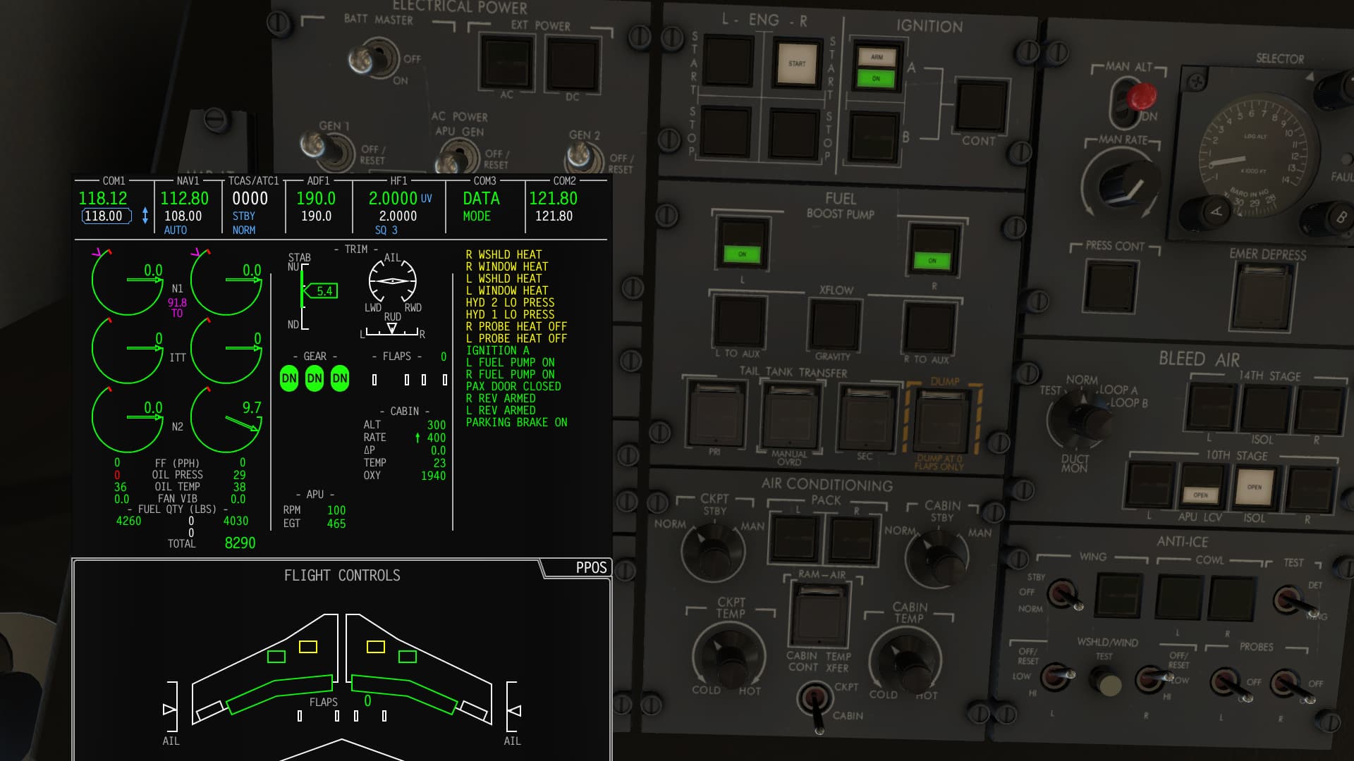
A quick check of the circuit breakers, a scan of the cockpit to make sure all the switches are where they should be and a test of the ‘FIREX’ system, it’s time to fire up the APU. Here we can see that I have the APU up and running with the APU Generator on. It seems to be powering the main AC buses, but the utility buses are shed. A quick glance at the overhead electrical panel shows that the AC/DC UTIL BUS switch needs to be pressed.
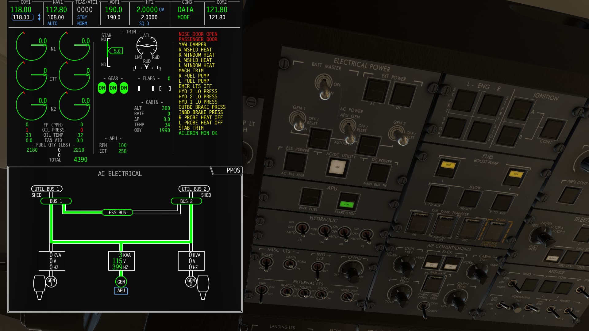
Next I test the hydraulic AC Hydraulic pumps…they look good, so I set 1B, 2B, 3B to AUTO and 3A to on.

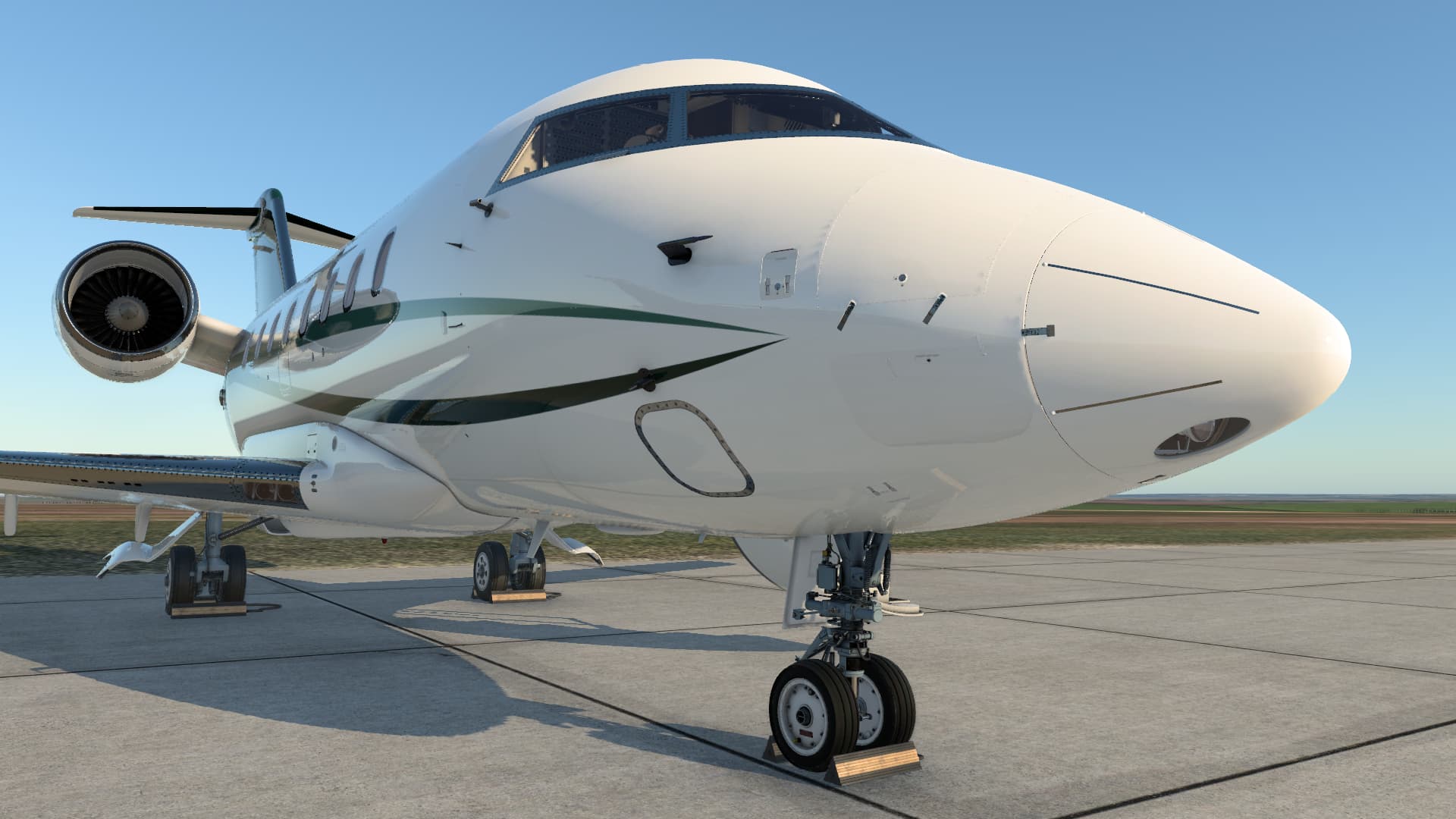
Now I head outside to close the nose gear doors by popping open the small under the nose. inside is the AC connector for a GPU and a small switch that lets you open and close the doors, assuming you have pressure in hydraulic system 3.

Next I head back inside and continue with systems checks and finally I download my flight plan via VHF Datalink. In the real world I would do my flight planning with ARINC. Simbrief is an excellent equivalent in the virtual world. I can retrieve the flight plan using exactly the same procedure in the FMS as I would in the real airplane. I also take a look at the plan on the SimBrief website to see how much fuel I will need, and then call the FBO for a fuel truck, which arrives a few minutes later.

Once the fuel guy confirms how much Jet-A you want (in gallons) then he hooks everything up and starts pumping.

With the fueling complete, I work on the FMS performance… It looks good so I send the V speeds over to the PFD.

With everything set up in the cockpit I do a quick walk through the cabin… looks like the ‘Airshow’ display is working well.

After another walk around to make sure the airplane still looks good, I close the door. From the inside that involves pulling the door up, depressing the lever with the red handle on the right and finally pulling a T handle which in this shot is hidden by a sliding cover. You then check for the green locked indication in the window next to the sliding cover. In the real airplane you would also check that all the locking pis are lined up correctly, but they are not modeled here.

Starting the right engine.
Both motors are spinning and it’s time to work on the after start checks…
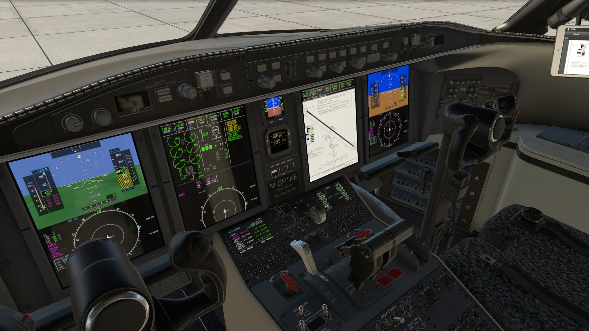
Lined up and ready to roll.


After all that work, we are finally airborne.

Climbing out…


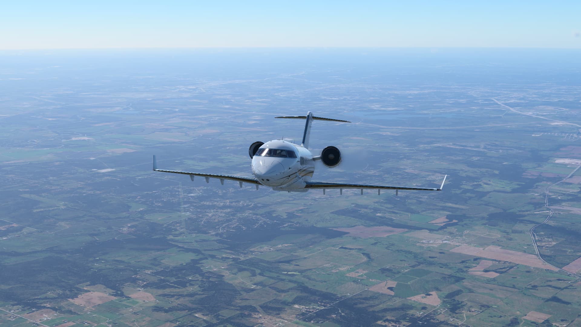
Cruising along at FL350.


Flying the UNARM7 arrival into Charlotte… everything is looking good.

Flying the ILS to 36R…

Gear down…

Short final, just a bit right of the centerline.

Touchdown!


Pulling into the FBO ramp…

Parked…

And shut down. I figured @BeachAV8R would be here to meet me with beer…but I guess not ![]() .
.

Buttoned up for the night.

12 Likes
That looks amazing! A couple of those shots I thought were pictures.
2 Likes