No, Lua is the ■■■■■■■ descendent of a scripting language written to be intuitively understood by oil-platform workers. It is preferred in the games industry because it is light weight, quick to execute, and interfaces very well with C and C++, which is what many game engines are built in. It is loathed my many software developers because if you’ve learned any of the aforementioned languages, Lua works just similarly enough that it makes you think you can just code like normal, but actually works differently enough that you are doomed to failure once you try.
I hate Lua
So the latest version of the DCS engine is supposed to support curved earth maps. However to my knowledge no maps in DCS yet take advantage of this. To get around this, DCS fools with the detection values to emulate a round earth, so while there is no radar horizon per se, the engine will muck with the values to appear there is one.
The Kuznetsov and Grumble Ships have max detection ranges of 290 and 260 NM respectively according to that code. I know that DCS takes altitude, relatively velocity, aspect, and RCS into account when determining detection ranges. The way by which this radar is defined is generic enough however that I don’t know how exactly it gets modified when actually fed into the engine.
I don’t know. All surface/surface radars are defined in the sensors lua. From what I saw, they have hard coded max detection ranges, but I don’t know if the engine is doing something per-model in the background.
Interesting…well given that this is a combat flight simulator and not an “combat everything simulator”–and it does a really, really good job with ground units and land based air defense–I guess I can live with a little wonkiness when it comes to ship vs ship stuff.
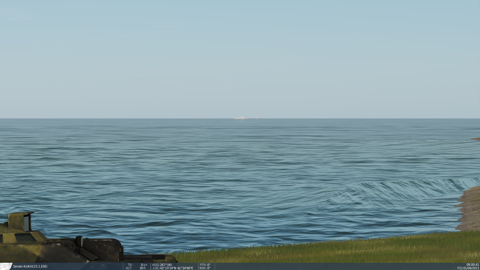
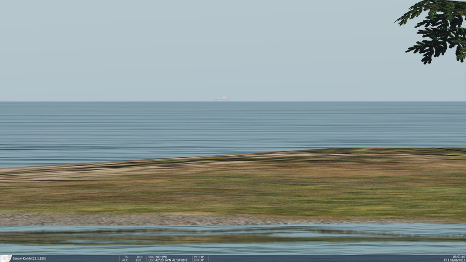
…I think I can test how well they are doing it…a mission where three ships are placed at 8 Nm, 12 Nm and 14 Nm from a beach coastline. I’ll land my brand new Mi-8 at the water’s edge (OK, I’ll land it wherever my nascent helicopter flying skills puts me and then taxi to the water’s edge).
For person at sea level at the coast, on a clear day, the horizon is 12 Nm (hence, per UNCLOS Part II, Section 2, Article 3, territorial waters only extend to 12 Nm).
So in the test, I should be able to see the ship at 8 Nm and just see the ship at 12 Nm but not see the ship at 14 Nm.
I’m not positive, but I believe DCS doesn’t model the curvature of the Earth. So instead they have visibility ranges that just makes things disappear beyond a certain distance. However, I don’t know if it takes altitude into account or not. Obviously at 36k feet you should see farther than on the ground, but all that has to be rendered.
Yep I figured it was something like that. I understand that the focus is air / air-ground combat where you are going to have a mountain or hill as your horizon. This was just a test to see if whatever they use to figure the horizon at sea was accurate. This quick test shows that it isn’t at sea level but no worries…I was just curious.
I guess I could try to get my Hip up to 36k feet and test it from there.
LOL…well I’ll be gosh darn! I was using MERSHIPs…but…wow…yeah, you shouldn’t be seeing that OHP at 30+ Nm. The fact that the ship is not “hull down” - i.e. you can only see the masts and/or superstructure - means that ED is using a flat earth…probably some “hazing” effect and/or LOD system…regardless, it works nicely
It might be lo-poly water at a distance not matching up with the height that it should. Or flat earth. That last Perry is in the area where there be dragons
Of course, gravity wouldn’t work as we experience it now if it was flat. Those near the edge would be pulled at an angle towards the disc’s center, not perpendicular to the surface.


 Movie CLIP - You're All We Got (1991) HD")