A Christmas Flight from SFO to Pago Pago in a Boeing 747-8i
Well turns out Santa needed a lot of Christmas presents delivered to Samoa, and he charted no less than a Boeing 747-8i to make the trip!
(The truth is I only have a day to do this, so I can’t make it a multi-leg trip, but what I do have is a Queen of the Skies in my hangar…)
So, instead of giving you all a harrowing week-long odyssey in a rickety Cessna, I strove to make this flight as accurate and authentic as I possibly could, adhering to airline and ATC SOPs to the greatest extent of my knowledge.
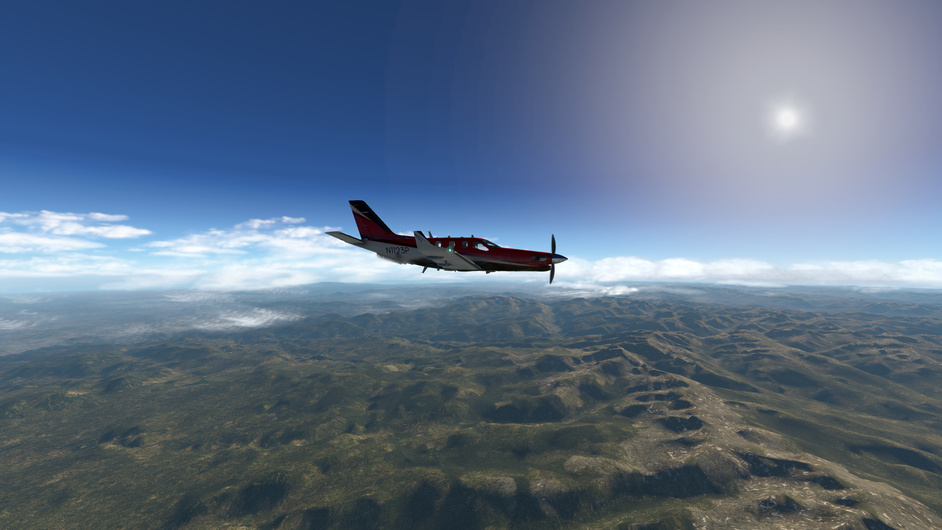
There are no direct flights of any kind between San Francisco and Pago Pago, so Santa had to go off-airline for this flight. He chartered N6067E, Boeing’s original 747-8i, with its beautiful “Boeing Sunrise” paint scheme. 6067E found its way to Gate G101, in the International Terminal of SFO, one of the few gates big enough to service it.
(And before you say it, yes I know N6067E has started a new life as the presidential VIP aircraft of Kuwait. Santa is magic.)
The 747-400 and 747-8 series are affectionately called the “ensuite fleet,” because they’re well-loved among pilots for having private lavatories in the flight deck. No more calling the flight attendant to block the aisle every time you have to go, and no more mingling with lowly first-class passengers!
My FO and received the 747-8i warmed up, as is nearly always the case, especially for aircraft that see constant line duty. I’ve already gotten the OFP from the gate agent. The time is now 1030 local; scheduled off-blocks time is 1130 local with calculated takeoff time being 1145.
As the FO runs through the preliminary flight procedure, I check all the switches on my EFIS to make sure nothing was out of place. I then turned my attention to the CDU preflight procedure.
Up first is the IDENT page. Model correct, bias adjustments correct, and nav data up to date.
Next up is POS INIT. To save memory, my company doesn’t include a database of gate coordinates, so we just enter the airport coordinates and then cross-check the GPS coordinates with the gate chart.
Since they match, I use the GPS coordinates for the initial position.
The FO has already logged into company datalink and is getting CPDLC data typed in for Oakland Oceanic, which we will log into after takeoff.
Meanwhile, the ramp handlers have arrived and are loading people and boxes into the back.
Dispatch has already sent an ACARS message that the route is ready, so I type in the route ID and send an ACARS request for the route over VHF. Shortly thereafter, I hear the bing-bong and the route is ready to be loaded.
As the handlers continue to load up massive numbers of presents, I cross-check the fixes in the route with what’s on the OFP. You can too.
Download the OFP
You’ll notice I wrote “MASTER” along the top. When making oceanic flights it’s critical that every crew member work off the same OFP, especially as dispatching is always a moving target, and over the course of an hour-long turn like this one, there could easily be 4 or 5 separate OFPs lying around the cockpit. It’s good practice to always destroy old OFPs when they are superseded by new ones, especially for Oceanic flights where there’s no radar ATC can use to tell you you’re following the wrong flight plan.
Fuel planning for these oceanic flights is a bit more involved too. Along with ETOPS fuel, which you can see in the OFP, we must also consider fuel necessary for the oceanic restrictions. We will be required to maintain a single airspeed and altitude when in the oceanic segment. If we can establish long-range communications, we can request step climbs to help save fuel, but there’s no guarantee of that. We must carry enough fuel to do the entire flight at one altitude, which is much less efficient. So you’ll see I carry a lot more fuel than is necessary to make the trip with the planned step climbs.
In addition, the 747-8i uses fuel flow to cool its hydraulic pumps. So we need to land with at least 30,000 pounds aboard to ensure those pumps get sufficiently cooled. Given the additional fuel required by ETOPS and the oceanic segment, this will not be a problem.
The FO leaves for the walk around, and shortly after comes another bing-bong and the PERF INIT data is ready to be loaded. Some of the numbers are wrong so I tweak the values and then accept the rest. The cost index is 150, but so little of the route is in class-I airspace that it really doesn’t matter. Most of the route will be done at a fixed airspeed.
I don’t execute yet; the FO needs to verify too. These numbers are preliminary. I then go back to the route, which still needs to be verified against the OFP.
With my dispatch in one hand and a colored pencil in the other, I scan down the list of oceanic fixes, circling each fix name in the OFP as it appears in the datalinked route. I then return to the top of the flight plan, and do it again, this time verifying the track and distance from each fix to the next. Each time I’m satisfied, I draw a slash through the circle.
Once I’m done, every oceanic fix has a circle and a slash through it. What I’m carefully checking for is off-by-one-digit errors in the oceanic fix names; for example 04W60 instead of 03W60. This is an incredibly easy mistake to make when typing in fixes, that will result in the aircraft being up to sixty nautical miles off course. We call this class of errors gross navigational errors, or GNEs. Whereas, say, on precision approaches the pilot’s concern is minor navigational errors that could result in the aircraft getting too close to terrain or obstacles, for oceanic flight, such small errors in navigation are not important (and indeed, prior to GPS, expected!). What is important is single-digit errors like these that can result in major deviations from the flight plan.
Once I’m satisfied, I accept the route in the FMC, but again, hold on executing until the FO is back.
Two more bing-bongs, and wind and descent forecast data has been loaded into the FMC for the entire route. I have a brief moment to relax and scan through the OFP before the FO returns from the walkaround. She reports nothing out of the ordinary.
The FO starts her CDU items, verifying the route and performance data. Meanwhile, I’m reviewing the taxi routing we can expect on the EFB.
As you can see, we can expect ramp control to clear us to push back, start, and taxi to spot “10”, which is adjacent taxiway A. Once at spot 10, we contact SFO Ground for our taxi clearance. I briefly discuss this with my FO so we’re both on the same page.
With the FO done with her items, we quickly run through the preliminary flight checklist on the ECL. Next she discusses the relevant NOTAMs with me (there are none relevant).
After about 15 minutes of idle conversation, the ACARS alert pops up again. This time it’s ATC with the pre-departure clearance (PDC), which I bring up on the CDU.
PREDEPARTURE CLEARANCE
N6067E
EXPECTED DEPARTURE TIME: 2030z
ROUTE CLEARANCE
ORIGIN:    KSFO    DEST: NSTU
DEPARTURE: 28L GAAP7.NORMM
ARRIVAL:   NA
VIA      TO
DIRECT   CINNY
DIRECT   MAFIC
This is the domestic portion only of the clearance, which takes us as far as MAFIC intersection. From there the oceanic clearance, which we will get from San Francisco Radio, will take over. I enter runway 28L into the CDU and select the GAAP7 departure, and add it to the route. The FO nods and I execute the change.
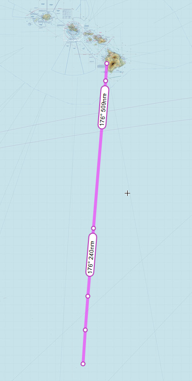
The rest of the route, which you can see on the OFP you downloaded, is all lat/lon fixes in standard ARINC format. Oakland Oceanic allows user preferred routes (UPRs, aka random routing, not along an airway) for any aircraft that meets RNP-4 navigational criteria. Fortunately our 747-8i does, so we can enjoy the fuel benefit of plotting a great-circle route to our destination, rather than following an airway.
The GAAP7 departure is easy to brief; it’s just flying a radial off SFO to a fix, and then vectors on course.
With about 20 minutes left until off-blocks, the FO and I do the weather brief next. San Francisco is bright and clear, with no significant weather to note. The enroute prog charts tell the story of the flight in three images.
The initial climb-out has us passing under the jet stream, but at a low enough altitude so as not to be a concern.
Once we get towards the equator, we will inevitably enter the inter-tropical convergence zone (ITCZ). This is an ever-present, turbulent band of thunderstorms and other nasty weather that hugs the equator. The SIGWX chart makes it clear that we will be threading two large areas of embedded thunderstorms, rising to far above our flight-planned altitude.
The descent is the worst news, though, showing us descending through an area of isolated embedded thunderstorms. We can surely expect to be vectored around areas of convective activity (or we will have to do our own avoidance), and we can inform our passengers to expect a bumpy ride on the descent.
The ACARS comes alive again; this time it’s the airport with the fuel slip, which is also sent to the printer. The rampers have also come back with the final tally on boxes and people.
I get the final numbers onto the master OFP and sign it.
I start plugging away in the EFB to do my final performance calculations.
With the performance data finalized, I do the takeoff performance calculations and start loading the information back into the CDU.
Per SFO noise abatement policy, I arm quiet-climb (Q-CLB), and then the FO and I cross-check V-speeds.
Since this is a flight in class-II airspace, it’s important to do a long-range navigation check. I cross-check the GPS against the IRU, and write the delta on the cover page of the OFP.
Five minutes to go. The head flight attendant has given us the OK signal, and the FO made a quick announcement on the PA to arm doors and prepare for push. The FO starts the APU and we both run our before-start procedures, then run the checklist.
With the flight deck door locked and the doors all armed, we contact SFO Ramp and tell them we’re ready for push. They clear us to push and taxi to spot 10, as expected. The ground crew, knowing our EOBT, is already there with the tug, ready to connect. I put on my headset, turn on the interphone, and give the ramper a ring. After a short back and forth, the parking brake comes off and the airplane is pushing off the blocks, about three minutes late.
As the tug positions the nose, I call for engines 3 and 4 to be started and throw the fuel control switches. Engine start, like the APU, is completely automatic in the -8i and does not need to be monitored at all. Still, I split my attention between the ENG page and the view outside. Once 3 and 4 are running, the FO opens the valves for 1 and 2 and I throw the switches. By the time the tug comes to a stop, all four engines are running. The FO puts the FCTL page up on the center display while I wait for the ground crew to show me the steering lockout pin.
I call for takeoff flaps. As the flaps go down, I cycle the flight controls. It’s important to do the flight control check while the flaps are in motion, to reveal any sticking or binding issues that might be present. The FO then completes her before-taxi items, we clear the area, and we’re off the short distance to spot 10.
Short of spot 10, the FO slips the radio over to SFO Ground, and I get my taxi clearance as the FO copies it down. It’s not a surprise, as there’s really only one taxi route that the 747-8i can take from golf terminal to runway 28L.
SFO Ground is quick to give us our clearance to cross the 1s.
The before takeoff checklist is quick and easy. I quickly review the runway and heading, and takeoff and climb settings with the FO.
SFO Tower has our takeoff clearance ready for us before we even get to the hold-short bars. The FO flips on the inboard landing lights as a reminder that we’re cleared to go. In the 747, oversteering is important on tight turns like this one onto runway 28L. Turn when the centerline is well behind you.
Once on the runway, I do a quick heading cross-check, activate the radar altimeter, bring the throttles up to 50%, and push TO/GA. The FO confirms takeoff thrust and I focus on the runway centerline.
80 knots (checked) … V1 (hands off throttle)… ro-tate! Smooth and deliberate back pressure to slowly bring the nose up, 2° per second about.
I watch the VSI, and cross-check with the radar altimeter. When both are climbing, I call “positive rate” and the FO swings the gear. At 400 feet, LNAV and VNAV light up, and I call for the autopilot. TO/GA lateral and vertical modes deactivate to make way for LNAV and VNAV, which flies the GAAP7 departure with the quiet-climb profile.
At 800 feet the thrust levers start coming back and the nose comes over. The airplane holds V2 + 10, making a slow and laborious climb with flaps to the acceleration height.
It’s a sight I’ve seen plenty of times in real life, 747s and A380s coming off the 28s, on the GAAP7 departure, loaded to the gills with gas for Hawaii or Japan or Australia, slowly crawling up into the sky on that quiet climb.
Our initial cleared top altitude is 5,000 feet, which ATC holds us at for now.
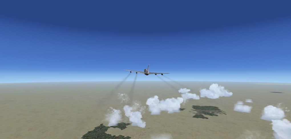
At 3,000 feet, the thrust derate is washed out and full climb power is restored. The airplane begins accelerating towards flaps-up speed, and I call for the flaps to come up as each speed is passed. Passing the up speed, the airplane continues accelerating towards 250 knots while heading directly out to sea.
ATC holds us low for a while, but once past the 3-mile continental airspace, finally gives us all the way up to our filed altitude, FL340. I dial it into the altitude window and hit intervene, and the airplane gleefully climbs.
Passing 10,000, the FO kills the landing lights and uses the center CDU to log into Oakland Oceanic CPDLC. She gets ADS-C reporting going and gets the active HF frequencies to use.
With 20 minutes until our first oceanic waypoint, the FO contacts San Francisco Radio on CPDLC and requests our oceanic clearance. It comes in via the center CDU:
KZAK CRNCE
N6067E CLRD TO NSTU VIA
MAFIC
RANDOM ROUTE
29N130W 25N135W 21N140W 20N141W 11N150W10N151W 03S160W
PASSA B577 TUT
FM MAFIC/2016 MNTN F340 M086
We received the UPR we filed, a random routing between MAFIC and PASSA intersections, where we rejoin the B577 airway.
Because there’s no radar over the ocean, there’s only procedural separation. So every oceanic clearance must have three important elements: a time to arrive at the first fix, an altitude to hold for the oceanic segment, and a speed to maintain for the oceanic segment. By holding those three things constant, aircraft are separated by time and space. I program the FMC with our new oceanic parameters.
Using the RTA feature, I configure the FMC to cross MAFIC at 2016Z. It shows an RTA speed of Mach 0.847, which is doable, so I accept it.
Next I set a Mach 0.86 speed restriction at MAFIC and all waypoints thereafter.
Finally, I perform my coast-out checks. The three altimeters are cross-checked for RVSM compliance, the compasses are checked three ways, and the HF check was already done by the FO. Sadly, I’m unable to sneak in a nav check before getting out of range of the nearest coastal VOR, so I’ll have to skip that one for now. I record the results in the OFP.
It’s smooth, bright, and clear as we cross out of domestic airspace and into Oakland Oceanic’s control. NorCal hands us over to San Francisco Radio, and the FO checks in over HF and sends a quick SELCAL check. With that done, the HF is muted. All future comms will be through CPDLC if possible.
About a half hour after crossing into oceanic airspace, it’s time to initiate SLOP (strategic lateral offset procedures). I have the option of flying either the course centerline, 1 mile to the right, or 2 miles to the right, and I can choose randomly among the three. In theory, this decreases by one-third the chance of a collision should someone make an error and end up on my course.
Of course, no pilot is truly random. Only 20% of pilots choose the 2-mile-right offset, and so for maximum safety, that’s what I choose. I plug it into the RTE page, the FO confirms, and I execute it.
The transponder is set to 2000, as is standard in class-II Pacific airspace, and I tune 121.5 on my VHF radio, and the FO tunes 123.45 on hers. We maintain a listening watch on these air-to-air frequencies in case something happens and we need to manage our own separation from nearby aircraft.
Ten minutes after crossing MAFIC, it’s time to plot our present position. I grab the GPS coordinates from the PROG page, and plot them on the route chart. This is another defense against a GNE – if one of the lat/lon fix names was off by a single digit, you would easily be able to tell after 10 minutes by comparing your plotted position to the route line. Everything looks good this time, though.
Not surprisingly, the first FMC-calculated step climb is early in the route, as all the fuel used to get off the ground and up to 34,000 feet is now gone, and the aircraft is lighter. As we approach the S/C marker on the map, the FO sends a quick CPDLC request to ATC, requesting FL360. A minute or two later, ATC comes back with the climb instruction. I punch the ACPT button and up we go. I monitor the level-off at 36,000; RVSM requirements dictate that the overshoot not be greater than 100 feet.
Zooming the ND way out, I can see our first FIX, midway between 25N35 and 21N40. This fix was copied from the OFP, and marks the location where, in case of a diversion, it is better to continue towards Hilo International Airport in Hawaii, rather than turn back to SFO. There’s a second fix further down the flight plan, which marks the equal-time point between PHTO and Pago Pago Airport.
These equal-time fixes were given to me by Dispatch for my convenience. The 747-8i is indeed ETOPS-certified, but it’s certified ETOPS-330, giving it a 330-minute deviation radius for planning purpose. This ample deviation radius means no intermittent ETOPS airports are required between SFO and Pago Pago, as the 330-minute radius around both airports is enough to encircle the entire route. However, any long-haul pilot will tell you that ETOPS planning alternates are just that – for planning only – and in the event of a real diversion, you choose the airport that works best for you. Hence, Hilo International was added to the flight plan, as it is a more realistic choice of diversion for this leg of the flight.
The weather remained clear and smooth passing down through the 30 latitudes.
Getting down to the 20s, though, things started to sock in below us.
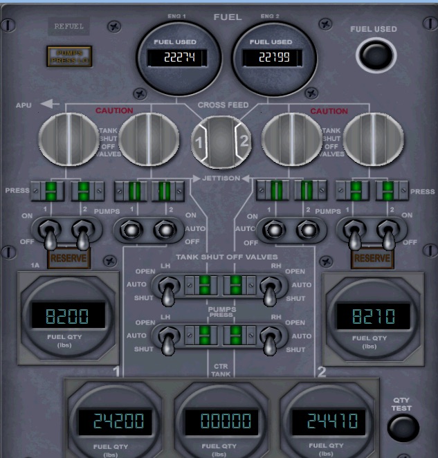
Two hours and 15 minutes into the flight, the FUEL TANK/ENG light came on, as is to be expected. As you can see on the FUEL synoptic, we started out with the inboard tanks only feeding all four engines using the powerful override pumps. Now the total in each inboard main tank (45,700 or so pounds) is about equal to the total amount of fuel in each outboard tank plus reserve tank. At this point, it’s time for the FO to set the pumps and crossfeed valves for the “tank-to-engine” configuration.
And done. Each engine now feeds off its own tank (with 2 and 3 sharing a crossfeed), and fuel will drop at the same rate across all six tanks. The EICAS warning disappears.
Crossing south of Hawaii, on our closest approach to the big island, the weather continues to thicken up. It’s time for another step climb to FL380. The FO makes the request over CPDLC, it’s approved, and I program the FMC.
The big mistake I made last time was not setting a speed for the climb. In procedural airspace, your cleared airspeed is to be maintained at all times – regardless of if your ETA changes, if you’re climbing or descending, or anything. Procedural separation relies on consistent airspeed. Without setting a speed for the last step climb, the aircraft did the climb at the default ECON speed, and I had to speed intervene to fix it. This time, I’m not making that mistake. You can see I dialed in the new altitude as well as a speed for the climb: our cleared airspeed, Mach 0.86.
As we continue to progress through the flight plan, I add another slash through each fix after verifying the ACARS automatically sent a position report. (If it didn’t, I would have to manually give the position report over HF.)
I also cross-check ETA with ATA, estimated fuel with actual fuel (and I include the minimum required fuel in parentheses), and I verify that the aircraft turns to the heading shown on the OFP.
I’m also continuing to plot the 10-minute positions after each fix and verify we’re on course.
As we fly below 10° N latitude, the intertropical convergence zone comes into view. As predicted, there are isolated thunderstorms in pockets ahead of us. For now I maintain the course (well, 2 miles right of course because of SLOP), but I’m ready to make a heading change if I need to. The course keeps us clear of the major storms, and we pass through the ITCZ unscathed, though the FO put the seatbelt sign on for the duration of the equatorial crossing, to keep people in their seats as we plowed through the bumpy air.
For the first time since leaving SFO, we have a sighting of land! That’s Kiribati, an excellent diversion option if we need it. The island is just south of the equator.
Shortly thereafter we cross into Auckland Oceanic’s airspace. The CDU has already automatically logged on to Auckland CPDLC, and a message arrives with the primary and secondary HF frequencies to use. The message says CONTACT, not MONITOR, so the FO flips the HF back on and makes crackling voice contact with Auckland. She then passes along another SELCAL test, and all is well. The HF is once again muted. The ADS-C page now shows Auckland’s contracts as well as Oakland’s.
Passing out of the ITCZ, the air is once again smooth and bone-dry. The next fix is PASSA, which puts us on the B557 airway. There’s also a step-climb to FL400 indicated, and so I request it from Auckland via CPDLC, and it’s quickly approved. Up to FL400 we go.
Approaching the end of our oceanic segment, we’re greeted with more pockets of isolated convection. The weather radar shows the pockets; I monitor the route to ensure we remain clear of the worst areas.
One of the pockets intrudes on the flight path; normally this would require attempting to request a route offset over CPDLC, but from the weather radar it looks like simply removing the SLOP should be enough to avoid it. Pilots have discretion to add or remove SLOP as they wish without getting clearance from ATC. So I simply cancel the SLOP, rejoin the route centerline, and narrowly avoid the thunderstorm. The seatbelt sign goes on and we ride the turbulence for a few minutes.
Unfortunately, the next obstacle wasn’t so forgiving, so I have my FO request up to a 15-mile right offset from course to maneuver around the thunderstorms. ATC comes back over CPDLC with the approval, and a requirement that we report rejoining the course. I use my new 15-mile maneuvering room to thread between two cells. At this point, the seatbelt sign is likely staying on until we’re parked. I inform the passengers of the bumpy ride to come.
Just as we’re clear of the thunderstorm, I hear another bing-bong. It’s Auckland telling us to contact Faleolo Approach on VHF. Rather than go through the hassle of trying to send another CPDLC message, I simply tune the VHF, contact Faleolo, and tell them I’m resuming my normal course. They confirm my message.
I steer the aircraft back on the centerline. Faleolo passes my domestic flight plan, which will take over once we finish the oceanic segment.
“N6067E, after DARMA, cleared to Pago Pago via radar vectors Pago Pago VOR, maintain FL340. Squawk 6163. Expect ILS runway 05.”
I read back the clearance and append the ILS to the CDU route. It’s time now to do the descent prep. I know from experience the gotchas of the ILS runway 5 approach, which I discuss with the FO. We also cover the airport and taxi briefing.
As you can see in the notes, heavy aircraft are required to roll out the entire length of the runway, then back-taxi to the terminal. Also, Pago Pago has only one stand large enough to accommodate a 747-8i, and taxiing into it is tricky. I brief the FO on what to expect, and how the ground crew will help us maneuver into the stand. Finally, we cover the relevant NOTAMs for Pago Pago – an approach frequency has changed, and the AWOS is out of service.
Yet more thunderstorms as we approach Samoa.
Crossing our last oceanic fix, I verify that the SLOP has been removed, squawk the domestic code, and resume ECON speed. A short while later, the FO checks the ADS-C page to verify all remaining contracts have been closed.
Pago Pago’s weather reporting is out of service by NOTAM, so Faleolo Approach passes me their current weather. With that information, I do the last descent planning item, approach data. The FO confirms the numbers and I transfer them into the APPR REF page of the CDU.
I grab the forecast landing weight from the PROG page and plug it in. VREF is always flown with an additive; for calm winds like what we have here, that additive is only +5 knots. So I set VREF+5 as my approach speed.
We brief the landing and then run the descent checklist on the ECL.
Approaching Pago Pago, I do a coast-in nav accuracy check, cross-checking the GPS fix against the nav radio data. Everything looks good. We cross DARMA and commence our domestic flight plan.
Faleolo Approach gives us a heading for the approach and pilot’s discretion all the way down to 5000, so I roll the selected altitude down, and once crossing the T/D marker, the airplane begins it’s descent.
It’s a bumpy ride the whole way down, through turbulent air. Faleolo gives me a couple heading changes to avoid some areas of strong turbulence.
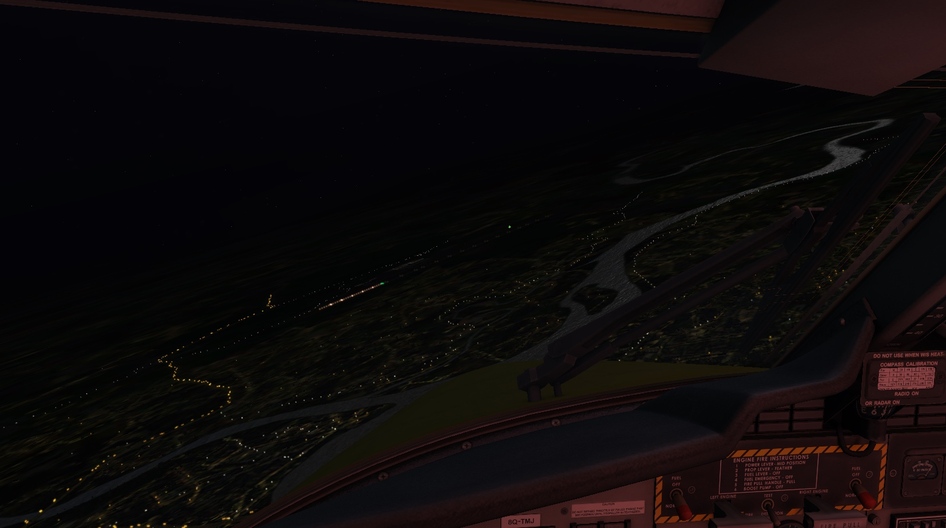
Finally, descending through about 15,000, first sight of the island is made, peeking out between cloud layers.
Passing through 10,000, the FO flips on the inboard landing lights, and we run our short approach checklist. I verify that the ILS frequencies and courses are dialed in and correct, and turn on APCH mode on the IFSD.
Faleolo Approach gives us vectors for a downwind leg, preparing to turn us onto the ILS. I speed intervene and slow the aircraft down to 210 knots, commanding flaps 5.
Out past GRUPY, Approach finally gives us an intercept heading and clears us for the ILS. Faleolo only controls inbound aircraft down to 5,000 feet. Below that, you’re handed off to CTAF and you’re on your own. With our clearance in hand, and at 5,000 feet, Faleolo hands us over to CTAF frequency. My FO switches and sends a position report.
And we turn onto the ILS. I arm APP mode, and the autopilot eventually captures the localizer. I command gear and flaps 10.
At BLUJA, the aircraft intercepts the glideslope. I cross-check the altitudes and command flaps 30. The FO runs the landing checklist with the ECL.
The FO and I gain sight of the runway at about 1,000 feet. The approach is stable, so I click off the autopilot and auto throttle, and transition to the visual approach.
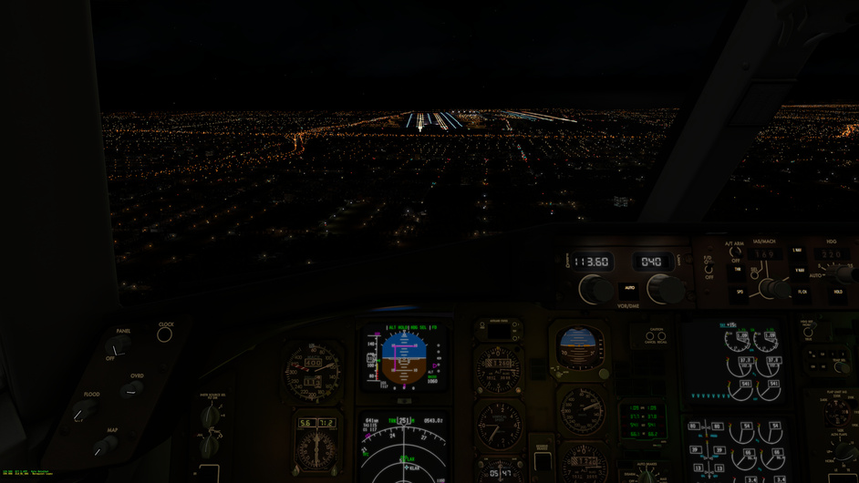
The aircraft arrives at minimums with the runway plainly in sight. In this picture you can clearly see why minimums are so high (845 feet vs. the usual 200) and far back – look at that cliff rising right up into the approach path!
50… 30… 20… 10…
Touchdown was moderately firm and just short of the touchdown point.
The FO calls reversers green, speedbrake deployed. At 60 knots I call manual braking and the FO confirms the autobrake disarms. I bring the airplane to slow halt at the very end of the runway.
The 747-8 is an awkward beast to maneuver in the turnaround spot. In this picture I track the wrong centerline.
Back on track.
When back-taxiing, it’s important to taxi offset from the centerline (wingspan permitting). It helps increase your visibility to oncoming flights. My FO announces the back-taxi on CTAF. No other flights are approaching, however.
We take taxiway C off the runway to the ramp. The FO starts the APU; there’s no gate power here.
The marshalers meet us at the ramp to help negotiate the tricky parking.
Parking brake set! The marshaler heads to his next spot while other rampers unload the aircraft.
The tall view from the cockpit! I verify APU bus power and kill all four engines. The FO runs the shutdown and secure checklists while I pick up all the coffee cups and food containers and hand them to the FA.
I hope you enjoyed this flight. I couldn’t make it an epic journey by time or stops, but it was epic in its own way, in complexity and technology. Regardless, Santa will take any ride he can get, and there’s no better aircraft than the Queen of the Skies to get hundreds of thousands of pounds of Christmas cheer to islands across the Pacific.