Great report…love the JetStream. They always struck me as not having enough wing for the fuselage. I fly with a bunch of guys that used to fly the CCAir JetStream 31/32s. No autopilot. Good times.
Oooh…and a 707… ![]()
Great report…love the JetStream. They always struck me as not having enough wing for the fuselage. I fly with a bunch of guys that used to fly the CCAir JetStream 31/32s. No autopilot. Good times.
Oooh…and a 707… ![]()
I’m using the sound set from that Mossie. The JustFlight one sounds better at idle, with some very nice initial rough running and backfire sounds. But they continue at cruise, which is annoying. The sound from that freeware Mossie at cruise sound more like that from this video IMO.

I’m just catching up with all the reports. Great flying and thanks for sharing all.
My own flight… I failed in the timeframe for the second year running. Moving house and having your PC in storage really hampered things, then after the move was getting ready for a skiing trip. First world problems. ![]()
Now back up and running, I’m going to get there over the next couple of weeks, assuming its ok to be late, I’ll post up the legs. As penance, I’ll take all the party streamers and empty beer cans to the re-cycling plant. ![]()
Thanks all again for posting up your legs, its been great reading whilst I’ve been grounded.
Haha…I think if I went to Pago Pago in real life I might never come back…so yeah, late is fine, I’ll still be there… ![]()
The only rule is that there are no rules… Just try to get there before we start the 2019 Christmas run ![]() .
.
So where are we headed this time? ![]()
Roi Namur in Kwajalein?
A secondary benefit for the minuscule number of history buffs among us is that you can fly over the wreck of the German cruiser Prinz Eugen.
Wheels
After a fitful sleep, I managed to secure a Hornet ferry to Honolulu ![]() All I can say is that I’m underway and ready to stick my toes in some sand. It’s not the best weather in Juneau at the moment. Will update as possible (Wife is on a rampage to get us to some Chinese New Years festival.)
All I can say is that I’m underway and ready to stick my toes in some sand. It’s not the best weather in Juneau at the moment. Will update as possible (Wife is on a rampage to get us to some Chinese New Years festival.)
Continued HERE
Are those drop tanks full of replenishment beer? @Navynuke99 and @Hangar200 say the beer will still faintly taste of JP-4…
Wonder if the JP-4 leaves less of an aftertaste than the leaded gas used during ww2 when they did the same thing with their drop tanks??
Wheels
![]() Talk about a sore spot. I have flow into, and stayed, at the Army Air Field on the island just to the south east of the wreck. Unfortunately I was unaware of the wrecks existence at the time, and wouldn’t be until a number of years later.
Talk about a sore spot. I have flow into, and stayed, at the Army Air Field on the island just to the south east of the wreck. Unfortunately I was unaware of the wrecks existence at the time, and wouldn’t be until a number of years later.
That being said, Kwajalein sounds good to me. ![]()
Hampton to Pago Pago Leg 15 - Cairns to Pago Pago
The Return of the B707
Once again I got the fuzzy end of the lollipop with this ancient 707. Evidently MAD took the former TWA B707-300 that I left in Norway, refitted as a cargo 707C, registered in Norway and flew it to Cairns, in time for me to take it on this 2635 Nm last leg…even though at the time I left it in Norway I didn’t know what the acronym MAD staid for and had no idea that Cairns would be my last stop before Pago Pago.
That’s my story and I’m sticking to it…just hit the “I Believe” button and move on.
Now that the plot is sufficiently convoluted, lets move on…”Cairns, dang it I’m still in…”, nope, already did that…”A long time ago, in a galexy…”, makes no sense… lets try…
"Call me Hangar200”…
The MAD agent dropped me off at the 707C at 1123 local. I met my new crew…except it was my old crew, the one I left in Norway…(awkward!). I decided to ignore their glares and get right to work and assert my authority!
“The problem we had with this jet before was unpredictable fuel usage.”, I stated confidently.
“… a pilot that can’t do arithmetic …”, mumbled the FE.
I ignored him and continued, “We also had an issue with the CIVA system on the Leg to Norway which forced us to divert to Iceland.”
“…the pilot accidentally shut it off…”, said the copilot in a stage whisper.
I shook my head. This insubordination could not be allowed to continue. I had to think f something fast.
“Did I mention that I’m buying the first round when we get to Pay Pago?” I asked cheerfully.
“The best pilot ever”, they shouted in unison.
With crew morale issues settled we went to work. First was the route:
YBCS SID NONUM J64 CS G591 LTO B599 NN G224 SETTS DCT NSTU
Next, I was going with a full bag of gas for this flight. That would be more than enough and Cairns’ 10510 ft runway would be more than long enough to handle the jet’s takeoff distance at that weight…weight…
“So how much cargo are we taking?” I asked to no one in particular. Not surprisingly, nobody answered, but soon found my answer as I watched the loading.
Add that to the base weight to get the ZFW …then fuel to get Gross Weight…subtract 500 lbs for taxi to get Take off weight and…actually it doesn’t matter since I can’t find the V-speed tables so we’ll set V1 to 150 KIAS and Vr to 155 KIAS.
Starting a 707 isn’t that hard and only takes a few minutes. (We are saving weight by leaving the checklists behind.) The part that takes the longest is aligning that @#%$ CIVA INS platform.
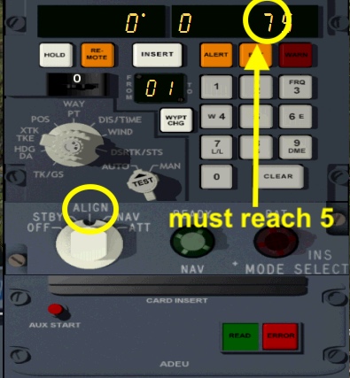
To save some time, I’ll be using the route card reader unit to populate the waypoints. There are 16 waypoints so that requires 2 “cards” (data files); one for the first 9 waypoints and one for the next 7 checkpoints. When going from WP 8 to WP 9, I’ll load the second card. I have just created these data cards…no time to double check. We’ve got Xmas gifts to deliver
(Note the foreshadowing)
While we are waiting, I start engines. when the INS is finally aligned we were set to taxi…so we did, behind an Air New Zealand Airbus.
As predicted the takeoff is a little bit longer than when I tried to take less fuel.
It was a nice clear day with little traffic, as I climbed I began an abridged SID, climbing to the west…
…before coming back towards the airport, crossing the CS VOR DME.
Then heading out to sea on G591.
Like the Cochin to Darwin leg, this was mostly over water.
The highlights:
New Caledonia:
I noticed here that the INS had drifted a couple of miles.
I would have (read “should have”) done a DME update on the LTO VOR DME when approaching New Caledonia and then another on the NN VOR DME when approaching Fiji. However, at this point I was not too far off track and I could visually see the deviation.
“OK crew, I think we’ll skip the DME updates. As long as the data is is good, we’ll be fine.”, I said confidently. The crew just smiled back at me…I hoped they hadn’t gotten into the Akvavit. (More Foreshadowing)
OK, something was definitely wrong. We were heading for waypoint 9.
I was picking up the NN VORDME, but it was pointing off our course–it should have been strait ahead. We couldn’t be drifting that much…could we? (flash back to a memory saying “As long as the data is is good, we’ll be fine”).
I brought up individual waypoints and check them against the flight plan. Sure enough WP 9, the ALBAB fix was reading S 19º19.9’. It should be 18º19.9’. I was heading farther south. I recall from my midshipman days that 1 degree of latitude is 60 Nm of distance. However, over the course of a 326.3 Nm leg, it actually isn’t that bad…OK, its bad but it is not irretrievable. I only had a few miles to WP 9 I waited for the switch WP 9 to the new WP 1. The new heading and VOR needle to NN matched up.
Fiji:
When I got to NN, I was more than a couple of miles off course.
I could have done a DME update on one of the other DMEs in the area…but… I had checked the rest of the WPs and they were correct.
Besides, it was a bright mostly clear sunny day with visibility out to maybe 50 Nm at altitude. How could I get into a situation where I was not be able to see an island or two as references?
About a 45 minutes later the sun went down in a spectacular sunset.
There was no moon. It got very dark…and very difficult to see any islands. (sigh)
Checking on fuel…
Each engine s burning 3,000 lbh x 4 = 12000 lbh. At NN I was 717.6 Nm from NSTU. My GS is 490 knots. I have 95,000 lbs of fuel on board. I use a slower average GS and calculate I’ll need 18,100 lbs for the rest of the flight. That makes it a 76,600 lb reserve. That should be a conformable margin fora couple of MA/GAs
Did I mention it had gotten pretty dark.
I start using the Doppler to back up the CIVA. What?Me worry?
I finally pick up the Pago Pago (TUT) VOR DME. I’m done rolling the dice with the INS. I switch to VOR tracking on the autopilot.
I was hoping for NSTU RWY 5 so I could fly the ILS. But the tower gave me a right traffic to RWY 23. Fortunately there were no low lying clouds but I never like right traffic approaches if I am sitting in the left seat…too hard to pick up the runway.
I went too far left on the base leg and needed to come back…then too high and not aligned close in. I threw away the approach and went missed. This time I use the left traffic pattern and get lined up OK.
Short final.
Clearing the runway.
And finally parked at the terminal - Mission Complete…almost.
After opening the main cargo door I checked my watch. It is 20:30. I had mad it to Pago Pago with 3 ½ hours to spare. It wasn’t even close. I relaxed as I waited for the MAD agent to arrive with a cargo loader…and I waited…and I waited…
I was more frustrated than worried. My copilot had called MAD World HQ to report “Safe on Deck” and they would notify the Pago Pago agent. Still it was unusual for MAD operations to miss an arrival.
When the agent finally arrived he looked disheveled.
“”You are early!”, he declared, “We weren’t expecting you until tomorrow!”
.
"Very funny”, I quipped back as I give him my paper work. I taped on one sheet, saying,”See, right here. Departed Cairns at 1123 local time, 31 December 2018. A 6.8 hour flight. We arrived at the gate here at 2050 Pago Pago local time.”
“Yes”, replied the agent as he looked over the paper work, “You left on 31 December and crossed the international date line. Today is 30 December.”
I stood and just stared at him for something like a minute before saying, “I need a drink.”
They did the unloading the next morning.
THE END
Thus ends my 2018 Mudspike Christmas whatever adventure.
I flew approximately 17,232 Nm in 15 legs heading east from Hampton Virginia. Yes, it would have been much shorter if I had gone west.
The originally planed Leg 2 CYQX to ENVA was broken into two legs due to a divert into BIKF for fuel and lack of navigation INS platform (the time I accidentally turned it off.).
The originally planned Leg 4 from ENVA to EDXH had a couple of diverts. I diverted to ENGA due to a fuel imbalance. Then after three attempts at EDXH, in a gnarly crosswind, I diverted (backtracked) to EDXW. Since that “mission” was all flown in the same day, I counted it as a single leg.
Starting at LSMA, I started flying aircraft that were either registered, or in the military of the country of origin for the leg. This resulted in a Swiss AW-109 helicopter and Piper Cheyenne, a Croatian DASH-8, a TAF F-4E, a Jordanian B707, A Kuwaiti A300, and a Maldives DHC-6 Float version. After that point I switched to MAD liveries.
I mostly used GA and COMAIR aircraft, but flew military planes three times–a RoNAF C-130, a USAF C-130 and the aforementioned F-4E. My longest flight was the non-stop VOCI to YPDN (9.1 hrs) my shortest flight in distance was the helicopter flight between LSMA and LSGS.
So what is next? I’m taking an extended vacation to fly around American Samoa (ORBX scenery) in my “Company Plane” ![]()
Yes…in the bug juice in the wardroom. ![]()
Excellent summary Hanger200, and you certainly made the trip an adventure. I very much enjoyed reading your entries, especially those in the 707.
But don’t bother saving a cabana for me. I’m being held hostage by my family today, which they’ve done for most of the holidays. Dratts!
Always nice to pick up a land based, traditional signal even when using INS or GPS. Just something reassuring about it.

Nice route…and great leg reports…! I’m at the bar. Wondering what all that racket was this evening out by the airport…
It just literally ‘Big Island’ in old Dutch ![]()
I’m going to file that piece of trivia away, I like that.
Leg09 Juneau to Honolulu (PAJN - PHNL)
Add-ons for P3Dv4 on this leg:
VRS Superbug and TacPack
Orbx: all layers plus PAJN
Active Sky P3Dv4 and Cloud Art
Departure from PAJN screen captures.
When I departed Atlanta in the DA62, I thought that I had a pretty solid flight plan:
But, that was wishful thinking and as Christmas approached, I got a big slice of RL pie when we went to Chicago for the holidays. Now those massive gaming laptops that some of you commercial pilots lug around began to make sense ![]() I knew that I would be late, but I just didn’t want it to drag on more than a few days past our loosely defined NYD deadline. To that end, I decided to eighty-six 4 or 5 legs.
I knew that I would be late, but I just didn’t want it to drag on more than a few days past our loosely defined NYD deadline. To that end, I decided to eighty-six 4 or 5 legs.
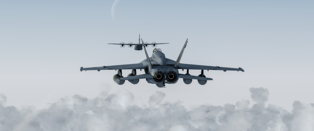
I hadn’t flown the VRS Superbug since the DCS Hornet entered early access, but sliding into the cockpit, it was a lot more familiar than the last time. In fact, other than a few differences like the glass UFCD and EFD, the Rhino cockpit feels right at home to a legacy driver.
The VRS Aircraft Configuration Manager (ACM) made configuring the Super Hornet for ferry a few clicks.
My route would be a simple one, fly direct to PHNL using a bit more magic than I had available in the Mossie. In my caveman way of thinking, I could put the HSI in Waypoint mode and designate PHNL as waypoint 1. I doubted this would work in the real world, but when the Waypoint pointer swung in the right direction and PHNL populated the Waypoint Data Block in the HSI, my confidence rose to acceptable levels.
There was this little issue of not having enough go juice to travel the 2441 nm, nevermind a 100+ kt wind slightly off my starboard nose for the duration. In typical Chipwich fashion, I would solve for this once underway. There would be plenty of time to tinker with Sporty’s excellent E6B phone app in calculating what I couldn’t glean from the FPAS page. The headwind and a couple of aerial refuelings turned my 6:33 flight time into a bit over 8:42. It was easily the longest leg of the trip so far and the most time I had spent in a Hornet in a single mission.
Departure from PAJN screen captures.
I decided to check in with a tanker not long after going feet wet, and via the magic of the VRS TackPack, a reasonably willing Air Force KC-130J appeared. In retrospect, I should have burned off a lot more fuel before making the call. But I was curious as to not only how the process worked, but how long the Rhino’s legs could be extended.
His reassuring presence filled my confidence mug further and without too much drama, I joined up and carried out a simulated refueling to the best of my limited TacPack familiarity. One of these days I need to find a good AI KC-10 to make it left less to the imagination.
No long after I topped off, he began a left turn to take up his reverse track. Thanks big fella. We would need your services again in about 1500 nm.
As you might expect, there was not a whole lot interesting to snap photos of for most the leg. I watched the sun catch us and roll overhead, watched a couple of bowl games, and generally marveled at the expanse of H2O.
When fuel got down to about 5500 lbs, I decided to get on the vine with our friendly Hercules crew and request fill up. They happily obliged.
This time it was us whom did the kiss-off and we took up our journey to warmer climes.
As the sun receded, likewise we began our long glide down to earth. In fading light the shores of Kahaluu emerged and I begin to sit a little taller in the saddle. The warmer air became expectedly choppy and the BVDs were really a bunched mess.
After cheating a little to the east, I popped over the mountains taking the shortest route to Daniel K. Some might ask why not land at Marine Corps Base Hawaii (Kaneohe Bay)? Because I don’t trust those Jarheads not to mess with, or requisition my ride while I get a short night of RnR. That’s why ![]()
While setting up for 4R, a commuter came out of the fog intent on the same runway.
So I slipped under his stern…
… came up on his port side and lined up on 4L.
As I shut her down, I reflected on how well the Hornet managed the trip, albeit at the cost of rigor mortis setting into legs and back. I thought about 2300 nm left and whether I should break it up into 2 legs. My cell phone rang.
“Chipwich, where the hell are you son? The last keg of good beer is about to kick!”
Great leg. Nice to hear there is a bit of crossover between the VRS Hornet and the DCS Hornet (even though they are different models). Wouldn’t it be neat to have a round world DCS where we could do long flights over semi-good (generic) scenery? Maybe someday. Then we can make it a multiplayer flight…!