That was very cool! Thanks for posting it @TheAlmightySnark !
1 Like
LEG 3 - KRHP (Andrews-Murphy, NC) to KPAM (Tyndall AFB, FL)
So as mentioned already, the Cessna 182 is the third aircraft I had flown in my logbook after the 152 and 172. Our flying club only had a couple of them, and they rented for more money and required a complex engine checkout, so they weren’t used as often as the 152s and 172s.
This flight takes us out of North Carolina and across Georgia to the hard hit panhandle of Florida to deliver some relief supplies to the battered area around Tyndall AFB and Mexico Beach.
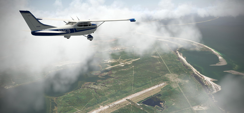
I elected to use the freeware Cessna 182 by Jason Chandler - an older model with not much glitz and glam, but it performs well and I wasn’t prepared to buy a super duper Cessna 182 for a single leg. I perhaps could have used the Carenado 185 which had a panel that looked like the old 182, but the performance and configuration (tricycle vs. taildragger) were big enough that I didn’t want to do that.

Off we go out of Andrews-Murphy with some clouds clinging around the tops of the nearby mountains…

I flew at 8,500 for a VFR altitude and the trip would take a bit over two hours…

Crossing PDK and ATL in the Atlanta area…


Fort Benning, GA…


After a couple hours of droning along, the coast of Florida came into view…

Turning over Tyndall to head east along to coast down to Mexico City…


Mexico City in sight…!

In an eerie coincidence, the X-Plane autogen only sparsely populates the ortho map…giving a sadly accurate view of what it resembles after the hurricane wiped out all but a few buildings… ![]()

Back over to Tyndall to drop off our relief aid…


8 Likes
Gonna try to knock out another leg tonight (can you tell I’m on call?)…
Short hop from Tyndall AFB (KPAM), FL to the west landing in New Orleans Lakefront, LA (KNEW).
Live track here: http://xfsd.ansorg-web.de/fsdmap/ (unless I get paged)
The fourth plane in my logbook is an odd one. The Quantico Aero Club managed to scrape up some T-34B trainers that they fixed up and put in the club rotation. One day my instructor invited me up to take one for a spin. He sat in the front seat and I sat in the back seat since I wasn’t technically getting signed off in the machine…although it did count toward a complex sign off.
Once again, without wanting to spend a bunch of money for single flights, I’m going to use the stand-in JRollon T-34C model, which is significantly different than the normally aspirated B model…but it’ll do in a pinch.

5 Likes


Landed KNEW with about 100 lbs. of fuel remaining (I only had about 800 lbs. when I left Tyndall). Weather was miserable in New Orleans…thunder…lightning and all that. And the JRollon T-34C is not XP11 ready apparently since the OBS ring on the VOR head is actually rotating like a compass while the DG is static. So I took a PAR approach via the moving map…haha…
KNEW 160251Z 05011KT 2SM +RA BR BKN037 OVC065 24/23 A3007 RMK AO2 LTG DSNT NE AND E P0046

1 Like
LEG 4 - KPAM (Tyndall AFB, FL) to KNEW (New Orleans / Lakefront, MS)
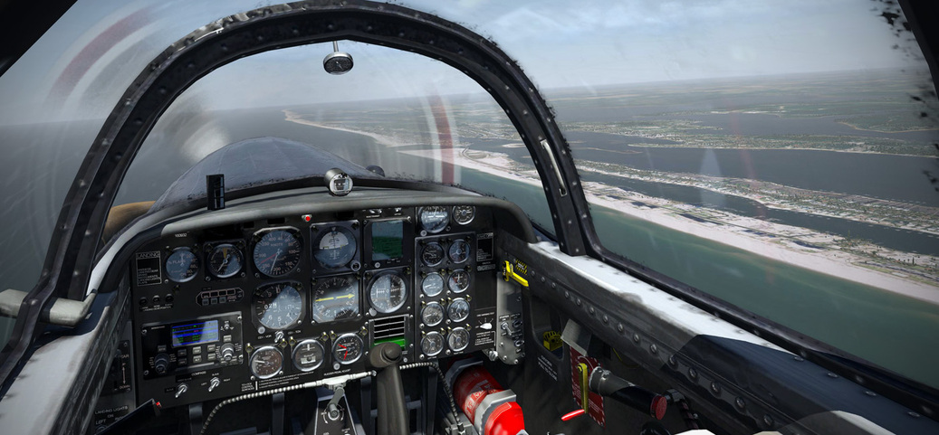
As I mentioned earlier, the fourth plane in my logbook was the T-34B, so I’m using the JRollon T-34C (the turbine version of the T-34) as my stand in. Unknown to me though, the T-34C has some X-Plane 11 issues. It is an OK plane for VFR, but with a non functioning DG and OBS, it is a bit of a problem in IMC conditions.
Departing Tyndall AFB…


I basically just stayed at around 3-4 thousand feet and drove down the coast and took in the views…

This would have been my view from the back seat of the tandem T-34B…

Having some fun enroute…


Fortunately the panel mounted GPS made it easy to just match track and bearing all the way to the destination…


Along the way, I decided to do a low flyby of Naval Air Station Pensacola…

I’m sure the Blue Angels were looking up at me and commenting on what a great stick I was…

Back out over the white sand beaches of Perdido Key Beach…

Toward New Orleans, the weather got crappy, reducing visibility to around 2 miles in heavy rain. No choice but to go lower and consult my map and find the Mississippi River and follow it up to Lakefront Airport…


In safely with the crack of thunder accompanying my taxi in…

11 Likes
I heard they scrapped their training sortie and hit the bar, too frustrated to go flying after being bested on their home turf…
Fragile ego’s, the Blues.
6 Likes
I knew I should have gone with the Thunderbirds livery… Drat…
1 Like
Never ceases to amaze me how pretty XP11 is in all of the screenshots you guys post.
4 Likes
The environmentals have really come a long way, but truthfully a large part goes to the ability of an end user to install ortho photo scenery. That’s due to some industrious individuals whom in a larger part give back to the community for little or nothing in return.
3 Likes
Forkboy and his ortho project transformed X-Plane for me:
2 Likes
If only flying X-Plane was like flying in DCS where there are literally hundreds of videos to show you how to fly particular aircraft as well as pretty decent manuals…
1 Like
They’re waiting for Beach to get out over open water, where there are no witnesses…
2 Likes
I thought it was because they were so inspired and in awe of somebody so skillfully handling the plane they all learned to fly in, that they couldn’t finish their preflights due to the tears running down their cheeks.
4 Likes
That’s the official story.
LOL, I should have added, “…while madly driving SSD sales…”
3 Likes
I see he has expanded it since I last pulled down the PNW, but I see he has Arkansas and Tennessee in the Midwest, Ohio in the Mid Atlantic, and me in the “unreasonably furious”. Where do I write to submit complaints?

Got started yesterday. No pictures, as to be honest bone stock FSX scenery isn’t worth it.
Austin Bergstrom (KAUS) to Albuquerque International Sunport (KABQ), in the trusty Real Air SIAI-Marchetti SF.260. I got this years ago, and it’s probably one of my favorite light complex planes. Reasonably fast, good legs, and fun to fly. Weather here lately has been rainy, and I had broken clouds up to about 10,000’ or so. The SF.260 is fully IFR capable, but I hate dealing with FSX ATC, so it’s was direct, mostly kinda VFR (in the real world I think the FAA would have wanted to chat when I landed). Myself and the better half (god save me if I take a halfway round the world flight without her) with 30 lbs of luggage, put me at full internal fuel and about half the tip tanks at lift off. By the time I hit the Texas border, the weather had cleared out, exposing nothing but miles of FSX stock desert tilescape. Yay. 20" at 2100 RPM, cruising along at roughly 10,000’ and about 160 knots indicated.
As I neared Albuquerque I started to wonder if I misjudged my fuel calculations. I was down to a bit less then 1/4 of the internals, and still about 100 nm out. I had plenty of diversion airports to work with, but I figured I could stretch it out. Lean out the mixture a little more, throttle back a bit, start a long slow descent… That work great, until I realized the airfield is on the OTHER side of the mountain range I had jusmtp descened in front of. Son of a…! There was no pattern at all, a quick break onto my assigned runway and down. I checked and landed with .2 gallons of usable fuel left in the AC. One of the advantages of sim flying!
Leg two, was a night flight up to Seattle Tacoma International in a Lockheed L-749 Constellation. Can’t a Connie fly pretty much from Austin to Pago Pago you ask? Why yes, yes it can, but what’s the fun in that? Take off was at dusk around 1930 local. The Connie is one of my favorite FSX planes period, yes it’s a big propliner, but man is it a blast to fly, I’m amazed it was freeware too (find it at calclassic.com). So with a full load of passengers, cargo, and the auxiliary tanks dry (Albuquerque to Seattle barely get’s those big radials warmed up and purring; okay actually it’s a 5 1/2 hour flight, but you get my point) off we went.
Having 10,000 BHP meant taking off at 5,000’ above sea level was nothing. Once a positive rate of climb was established, the AC was cleaned up and we started climbing. At 10,000’ it’s time to switch the superchargers into high blower, and with all those horses and plenty of gas, keep right on climbing. Weather was mostly clear, with light clouds, and good air. We hit the first step altitude (where we can no longer maintain at 500 FPM climb at a safe IAS of 150 knots), and leveled out around FL19. It took about 30 minutes to burn down enough fuel to start another climb. With one more intermediate step we finally hit our cruising altitude of FL25. We leveled off and with the throttles all the way forward had about 34", and we pulled the props back to 2000 RPM.
Nearing Seattle in the day there is Mt. Rainer, Mt. St. Helen’s, and Mt. Adams, but as expected it was cloudy. Oh and nearing 0100, so not much to see. Descending was a little more rapid than I like in a properliner (they are hard to slow down once they get going), but with the mountains, you don’t really have much of a choice. FL15 (at a minimum to get over the mountains safely) to 453’ above sea level. The approach went great UNTIL I got hit with a possible graphics bug. Suddenly the cockpit glass in the VC went opaque. Hmm, the 2D panel was fine, but the view angle is messed up and makes landings very difficult. Alright, well I had already dialed everything in for an IFR approach just for practice, time to fly the this on instruments.
Fortunately whatever the issue was popped back out about the times I was at minimums, so a nice easy landing. I settled down at about 87,000 lbs with barely even a tire squeak. And then I forgot how to engage the thrust reverses with a 43 ton aircraft doing 100 knots down a wet runway. Fortunately a LONG runway. I got stopped before I got to the last taxiway, and then found the clickspot for the reverses lol.
Tonight we’ll start the much more interesting part of this trip.
7 Likes