Yeah, that was always a great airplane!
![]()
In real life, that will happen in both the King Air and Citation if you don’t run windshield heat or bleed if you are descending into a warm and humid area. It sucks.
Yeah, that was always a great airplane!
![]()
In real life, that will happen in both the King Air and Citation if you don’t run windshield heat or bleed if you are descending into a warm and humid area. It sucks.
I didn’t get far in the christmas flight last year. However starting to read the thread again I get the impresion that I need to give it a try again! Just with which aircraft? My favourites are still the same (DC-6, PC-12). However probably I have to go for the new TBM 900. It look like this aircraft provides tons of exiting features that make a flight aourd the world a little adventure. Chck out the announcement at x-pilot!
Well if you go down somewhere, we’ll find you!
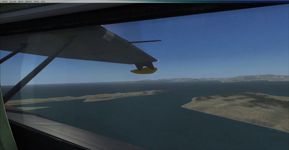
Still getting the hang of the Catalina. I’d had my eye on here for a while, and this seemed like a good excuse. Keeping the engines alive takes some practice, and I imagine as I get further north this time of year, over heating will be less of an issue. She lumbers around the sky, but in a fun way.
I “invented” something call pseudo-IFR (pIFR) in FSX.
Mudspike required Blatant Plug Alert: See Chapter 6 of “Power User Guide - QuickPlan”
The major problem with IFR ATC in FSX is that it doesn’t do STARs and Published Approaches. However, it does recognize SIDs as part of the “flight plan” (if you add them into the FSX flight plan…if not, just don’t switch to departure until you are on the FSX flight plan).
Start in IFR ATC. Get your Squawk and initial altitude. Fly under IFR VTC until cruising altitude. Cancel IFR and then request flight following. FSX ATC doesn’t “notice” that you are way above VFR airspace so it will merrily hand you off between controllers and give you traffic warnings for the rest of the flight. When you hit the approach, cancel flight following and contact the tower.
Is pIFR perfect? No. But it works and adds a semblance of IFR for most of the flight.
Hmmmm…I’ve got the JF Connie and am not all that impressed - a cartoonish cockpit and really not much to do…may have to take a look at the freeware.
Overheating becomes less of an issue…carb and prop/wing/fuselage icing becomes much more of an issue. I was working on a project that had a PBY flying around Greenland…I had to watch those temp gauges like a hawk. ![]()
I assume the Aerosoft PBY. I read the engine section about a dozen times - they have really done a great job with that part of the sim.
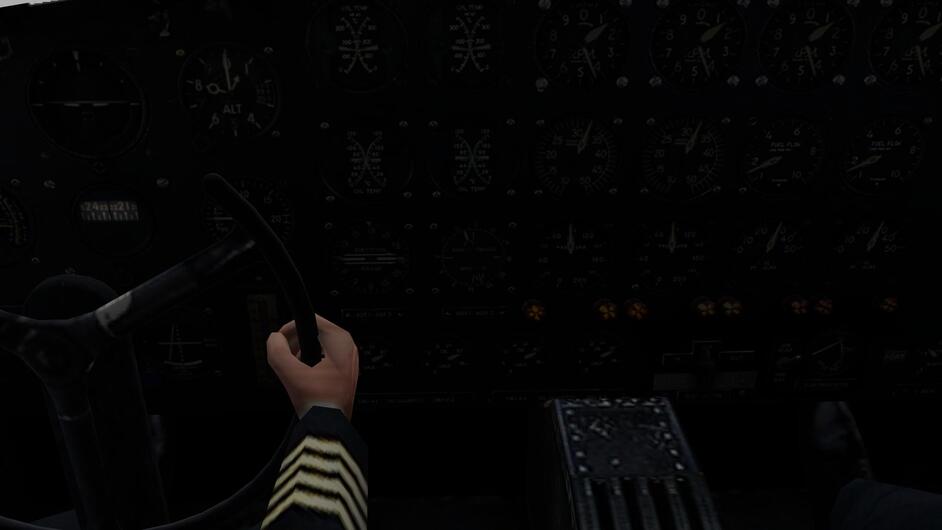
For all my flights, I have decided to use the CaptainSim 707-300. The only issue is that I do not yet know how to fly the 707…other than “Yoke forward-Houses get bigger; Yoke back-Houses get smaller, etc. I am working on a route to take me over some very rural / sparsely populated landscapes. My hope is not to end up like “The Flight of the Phoenix” (the one with Jimmy Stewart, not the remake).
The challenge will be using the “ancient” NAV systems - a Doppler system and a INS Carousel system…and of curse VOR & ADF…but lots of water, mountains, deserts, etc. along my route without NAVAIDs…Fun!
For the rest–checklists and operating systems–I’ve got an AA 707 Operations Manual that gives me a pretty good idea for all that stuff, especially fuel management (Did you know that when the FE left the cockpit to go to the lavatory, he was required to put the fuel system in a single tank to engine configuration…makes sense…I shall have to remember that !)
Before I begin actually heading towards Pago Pago, I need to do a couple of check / familiarization flights. The first was a short flight over western Virginia at 14,000 ft, fair weather.
The first challenge was getting it off KPHF’s 8000 ft runway with enough fuel to get me to Gander.
A success! with (a little) room to spare
Next was working the Doppler NAV system.
Coming up on the first way point.
The turn initiated automatically (and smoothly)
Settling up on the new course - after a few minutes the numbers began to “match”
Next FAM FLIGHT will be using the INS system along with the Doppler system…then it is off to Pago Pago.
Details…details… How hard can it be? ![]()
Interesting I like the idea of pIFR, I’ll have to try that at some point. Yeah the freeware Connie is great, it’s probably the most polished version, but the other ones they have are pretty dang good too. I’ve thought about picking up the A2A Connie, I just haven’t pulled the trigger. Their planes are great, so I’m sure it’s pretty solid too.
Yep the Aerosoft PBY, great bird. I had a good test flight going yesterday until for some reason the left engine, just lit on fire. Gauges all normal, and suddenly fire everywhere. Then again if it was a B-29 I’d say that was totally realistic, lol, so maybe just not my day for a flight. I figure I’ll learn a decent bit about icing as I keep heading N.
Seattle to Juneau - 800 NM or so, probably about 850 by the route I’m taking. Aerosoft PBY-Catalina, cruising along at her fast cruise speed of 92 knots IAS, or about 120 mph over the ground. 8500 ft, the two big Twin Wasps are purring along nicely. 30" 2100 rpm, temps are great, the outside air temp of 15F probably is helping with that. The skies are clear up here, there’s rain and probably sleet under the clouds at around 5-6,000’. I’ve got another 5.5-6 hours, I’m just about the N end of Vancouver island. I’m flying one of the variants that’s old school, no GPS here. It’s all NDB’s and VOR’s on the a gyro compass, so lots of pilotage. Fortunately the old school Sperry autopilot works pretty well to hold a course and keep her level. She’s easy to hand fly, but 8-9 hours of hand flying would be tiring. On the next leg which will feature a lot of open water, I’ll bust out the sextant, see if I still remember how to do that. When you’re cruising along slightly faster than a Piper Cub you have plenty of time to get good star shots.
Having had some time with the Cat’ after picking it up Tuesday, it’s a good plane. I do think they missed out, by not fleshing out the interior more. The observation blisters are fixed views, and there’s no flight engineer’s station. She handles exactly like I expected her to, which is ponderous, but steady. If you like to admire the scenery slowly passing by she’s a great choice.
What you should do is fly it over big sports events on the way! The Indy 500, the All Star Game and the World Series…a Bowl Game or two…perhaps Madagascar’s Hopscotch Word Championship…that type of thing. ![]()
Seattle to Juneau - approximately 820 NM, 8 hours and 12 minutes from takeoff to touchdown. Flying around in something that goes slightly faster than a zeppelin, and the climb rate of a sick pigeon when you take off fully loaded, really makes you appreciate how hilly and mountainous the terrain is in the pacific northwest. Particularly with the weather up there, it’s ummm, interesting/terrifying trying not to plow into terrain in the fog, while you slowly, ever so slowly, lumber up into rock free clouds. Once you do finally get up above all the rocks (assuming your engines haven’t lit off or faced some other catastrophic problem), you can throttle back, close the cowl flaps down a bit, and just enjoy the passing of the scenery. Too bad on a SAR ship like this one, there’s no in flight service.
Today time permitting we’ll take the next leg, which is pretty much open water for Juneau to Kodiak. Projected time of flight is 6 hours. I’ll see if I can remember to take some pics, as well.
The Cats’ definitely growing on me. She requires good management on takeoff, sure you’ll get airborne at 80 knots indicated, but you don’t exactly have a huge surplus of power to work with. You have to pay close attention to engine temps (and all my test flying has been up North where the temps haven’t gotten about 40F, I can’t imagine how this worked in the Pacific!), and it’s really easy to overheat them trying to climb out. She’s “stately” at low speed (which is all the time), so you have to plan where you’re going, and get started early. Overall she rewards good hand flying during the parts that are interesting, and has a workable “autopilot” (really heading and attitude hold system) for the parts where all you’re doing motoring along straight.
Moving further SE. Stil inside Romania.
from Maramures Airport to George Enescu Airport
Starting up 429. Weather was interesting
Flying E towards valey hoping I will be able to cross to the other side
Quickly it become no-go so turning back
Further down the SE route
Surely good weather doesnt mean we are climbing ![]()
Nice airport, lot of buildings, heliports and one rotor friend
Juneau to Kodiak - 576 NM - 6 hours and 10 minutes.
Pretty much a straight shot, point the noise to 246 and adjust for wind. Providing the engines don’t light on fire. Or die. Or we crash into high terrain on the way out. Or we get lost over the open water out of range of all the navaides. So yeah pretty simple.
The weather at take off is a mess, 39 degrees and driving rain. Fortunately I managed to get airborne and dodge the major hills in the area as I climb out.
By 4,500’ or so I’m out of the rain, and the wind seems to be steady rather than gusting.
At 92 knots IAS it takes a while to get away from land. That’s the Glacier Bay National Park slipping away in the distance.
The sun coming up is nice, but a little late to help dodge hills, cliffs, and glaciers. At the top you can see the cowl flaps are at about 80%, the Twin Wasp makes ALOT of heat at cruise power even when the OAT is about 10F.
Water, water everywhere. We’re far enough out that I can tenuously get a VOR signal, and NBD’s are a no go. I had planned to pull out the sextant, but forgot to add the gauge to the panel before i started this leg. So this is dead reckoning, and knowing that so long as I keep the nose pointed W or NW I’ll run into land. Plus I’m in a flying boat, so I can alway set her down where ever if I truly get lost and out of gas (hence why I picked the Cat’ for this part of the trip).
Land ho! About dang time, but at 120 mph over the water, we’re still an hour plus away. I had picked up the VOR at Kodiak a while back so I knew I was on course, but there’s no DME in the nav equipment, so it was all dead reckoning.
You don’t actually gain much drag at all with the floats down, or loose lift. Rather they catch wind like a sail for some reason. As we had a steady wind of 41 knots, and gusts into the 60’s it rather resembled a roller coaster! For as slow as the Cat’ is, there’s a decent bit going on during descent. Drop the power or the RPM to far, the engine will die. Pop the cowl flaps open to soon and the engine gets to cold? It’ll die. Keep them closed down, but you need to add a little power as you’re coming in? You’ll probably torch them unless you remember to pop the cowl flaps back open. Basically keeping the engines happy is a full time job (hence why there was a flight engineer) when you’re not cruising, and juggling the throttle, prop rpm, carb heat, and cowl flaps makes for an eventful descent to final.
On final obviously, with plenty of water to land in.
And we’re down, finally. A bit over 6 hours later, we’re in Kodiak.
We burned about 40% of our carried fuel load, at “fast cruise” of 92 knots IAS, over right around 600 nm. Per the book the spec max range is about 2190 NM, which would probably entail 12-18 hours of flight. 12-18 hours of very slooooow flight.
I’m going to have to see if there’s a repaint for one of the clipper nosed versions (no nose turret), so my trips can be more like this: All Aboard the Incredible Flying Yacht, circa 1950 (1950’s bikini cheesecake warning, so nothing that’s not on a billboard or commericial in your AO already) ![]()
I think we’re going to need a day in Kodiak to shake the kinks out, long cold overwater flights aren’t the most fun in a barely heated flying boat.
That’s a beauty…! The weather in Kodiak is rather breezy!
PADQ 200053Z 24017G24KT 10SM CLR 10/02 A2919 RMK AO2 PK WND 24027/2358 SLP883 T01000017
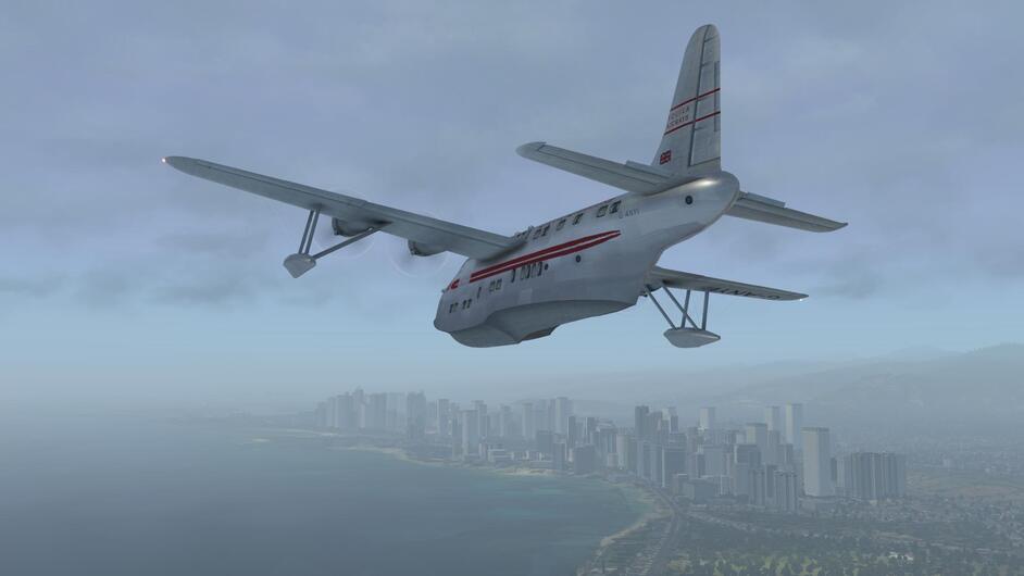
It was finally time to take a long flight over the ocean… San Francisco - Honolulu.
The Short Solent (by Michael Wilson), a post war evolution of the famous Sunderland. Here we are, shortly after sunrise taxiing out from the Pan Am facility at Treasure Island in the San Francisco Bay. I know this isn’t exactly historical, but it is the best I could do.
And we are off…
Gaining speed…
You Can Do It!..
Seriously… any time today would be great…
Finally airborne. She doesn’t accelerate well when loaded up with fuel. In fact I have to depart with less than full tanks because I couldn’t get the speed up enough to take off.
I made a gentle, climbing turn out to the West.
Ahead, the Golden Gate Bridge. Beyond that, nothing but ocean and, hopefully, Hawaii .
Heading out to sea… this is going to be a looooong flight.
It’s a big ocean, and suddenly my airplane feels kind of small…
The cockpit isn’t the greatest, but it certainly does the job. Not a single MFD to be found here!
More ocean…
After what seemed an eternity, I picked up the VORTAC at the Kaneohe Bay MCAS (the picture is dark, but the needle is alive!), . Awesome, no swimming necessary today!
Out of the murk, the first sight of land since we left San Francisco…
Beautiful weather! The Marine Corps Air Station is off to our right.
Because of the high terrain, I decided to just follow the coast all the way around to Honolulu… It was still raining as the city skyline came into sight.
And as if by magic, the weather improved as I got closer to the city…
Bob, my co-pilot seems quite pleased to be here.
Soon after passing the city, we come across Inouye Intl Airport (PHNL)
And just NW of the airport, we find our destination… Pearl Harbor.
A quick circuit around Ford Island…
and finally, it was time to land…
My plotting chart, showing the checkpoints where I allowed myself a navigational fix with notes on fuel state and True Airspeed.
Next stop will be Pago Pago, another long Ocean crossing. I think a few Mai Tai’s are in order first though.
A layover in Hawaii… Who wouldn’t be happy? ![]()
Well done!
The trip reminds me of the plotting navigational exercises we had to do in flightschool. Fun stuff!
Those surface reflections look great on that thing. Funny that she won’t carry full fuel. Is there any kind of “getting it on the step” procedure that is supposed to allow you to get that final bit of acceleration for the takeoff or something? Or maybe the engine model changes in X-Plane the last few versions have messed around with the power output of Wilson’s planes. You might shoot him a note though…he seems like the type of guy that would want to fix something if it is broken.
I liked your plotting chart!
I’ll try it again with full fuel. It could have been pilot error ;). In all honestly though, this leg was a little over 11 hours. At a cruise altitude of 8000 ft, with the mixture leaned back, I was able to get the fuel burn down to a point where I could cruise at close to 200 KTAS for over 15 hours. That gave me longer legs than the real Solent if the Wikipedia range data is correct. It is a great airplane for this kind of trip… stable, with an auto-pilot that allows heading and altitude hold, and plenty of range.
On a different note, I used SkyVector to create a navlog which includes Magnetic Headings and wind data. I did the same thing last year for the trip to Christmas Island. In the sim, last year I was using XEnviro, which I thought looked great, but over the ocean, the winds didn’t match well with SkyVector’s real world wind data. This year I used FSGRW and it matched the real world winds quite well (not exactly, but far closer than I experienced last year).