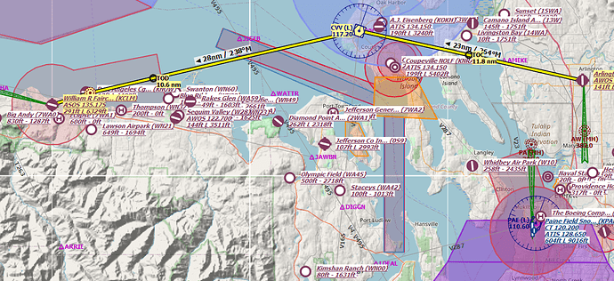
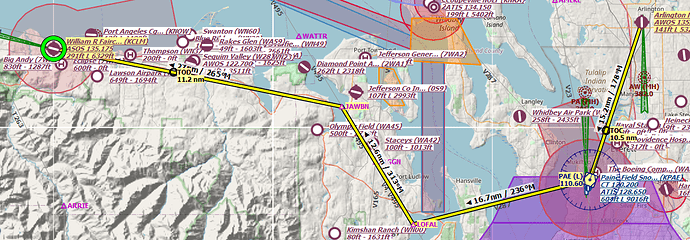
In preparation for some AH2XP action, I have been taking my AirFoilLabs Cessna C172S up for some familiarization flights around the OrbX Washington scenery area. That led me down a path of doing some rudimentary VFR flight planning, anticipating flying at least some of the AH2XP routes in IFR (or near IFR) conditions.
I also stumbled across this site (the Uncertified Pilot), which I thought was apt given that it somewhat describes me, that had me thinking of how I am planning my uneducated VFR flights.
For example, here is a route that I was planning from Arlington Municipal (KAWO) to William R Fairchild (KCLM). I usually look for VOR stations to help navigation (and try to stay away from my general tendency to use GPS as a navigation crutch).
I am looking, somewhat specifically at asking what a real pilot would do when poltting a VFR course. There is, of course, the get-in-a-plane-and-fly-eyes-out via visual landmarks and such … but I am noticing for the first time, the Victor (VFR) airways and wondering how much I should be trying to stick to those.
For example, should I be heading down to the PAE VOR and along V287 to LOFAL, along V495 to JAWBN and along VR (using the TOU VOR off to the West)?
Or is my original plan sound and correct?
Obviously, I don’t expect anyone to formally teach me but I would like some hints 
2 Likes
Neither are really wrong, per se.
Little clean up, Victor airways are just low-altitude airways and can be flown by VFR or IFR traffic.
As far as which you choose, it’s really over to you and there’s advantages and disadvantages to either.
Personally I’d probably take the northern route.
Real-life considerations would be that the north route has you going through Whidbey’s Class C so they’ll want to talk to you and I’d climb above the MOA. You’d also want a good plan if your motor quits over the water.
Why not the southern route? It’s just a hair less direct. You certainly can take airways but you’re not obligated to and in this case I can’t see much of a reason to go out of your way to do it. Also, there’s more likely to be IFR traffic on those airways.
But, that’s just me. Someone else might have a different view on how to approach it and be totally correct as well.
3 Likes
Disclaimer: I do Beta testing for FSWidgets and have written a manual for one of their apps - so while I don’t profit directly, I am not unbiased:
FSWidgets has a great app that works with XP called QuickPlan. It gives you some basic “maps” - street maps, imagery, etc. As well as some aero navigation charts. You can get add-on cloud based charts - for example US Enroute Low Alt charts
It has some other neat features like a side-view terrain overview of your route, various NAVAIDs, real weather overlays, etc. Works on Windows, Mac, iPod and Android tablets. It has a 30 day free trial (limited to the San Francisco region). Great support.
1 Like
![]()

