So this just landed:
Here’s a (totally uninformed) example of 90,000 Sq Miles superimposed over Hormuz:
That’s not a bad amount of real estate in which to play…
Has anyone made a direct graphical comparison between sizes of the actual DCS Caucasus map vs future DCS Hormuz map?

Some quick back of cigarette packet maths tells me that the map on thebattlesim.com covers an area >275K Square Miles.
So like Normandy and NTTR we’re only going to get a the immediate area around the straits in glorious detail. Still, that’s plenty of space for @near_blind and @WreckingCrew to murder us all in some devious missions.
90K NAUTICAL MILES
That’s what I thought initially, but it says “sq miles” in the video about 25 seconds in. Nothing Nautical 'bout that! ![]()
Either way 90K NM ≠ 275K miles. So the change in units will give us an extra third on the box in my first post.
Anyway, hope you’re right and we’re all pleasantly surprised.
I have already tooled around with the measuring tool in Google maps. It looks like Dhafra-Bandar Abbas will provide some space to work with. The other bases seem too clustered together and will be difficult to use in a sensible way. I am not too worried though, as before the 90s there was a lot less military infrastructure and Dhafra AB was the most important base.
So this is more of a GA question than anything else but I saw it in the new Hormuz screenshots so…
In the Abu Musa Island screenshot from the newsletter - can someone tell me what the white lines are for that I have highlighted? Are they just a visual alignment aid on approach?
A proper pilot will be along in a moment I’d guess, but I think those are visual aimpoint markers for touchdown (one for each landing direction). There are thinner touch-down markers before/after those at regular intervals, but at the correct angle in a visual approach, those are the puppy’s you aim for landing.
Wrong fearlessfrog. It is an indication to the pilots landing that your work day is done, party at 11pm, the usual place. ![]()
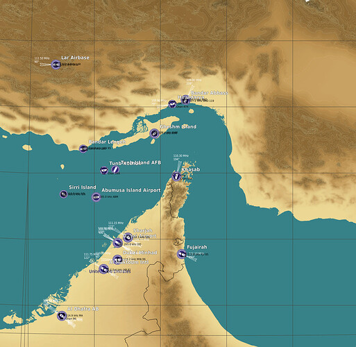
To avoid any confusion and be as transparent as possible, this image shows most of the map.
The general operations area for the carrier groups would be in the Arabian Sea.
Plus I guess the 5th Fleet will want to play as well.
That map is really going to be fun. I’m already thinking of some great ideas for missions for several modules, maybe even all together. ![]()
Thanks, I am now going to see those on every runway I look at and kick myself for a stupid question.
I have always aimed for the massive slick of burnt rubber…
![]()
Oh no. Concerned Gymnast wants more airfields at top of map before her next vault…
I’d usually post the Louis CK ‘Everything’s Amazing and Nobody is Happy’ gif, but it seems suddenly ill-advised.
@near_blind Did you really want Chabahar or funny looking F-14’s from Shiraz?
A runway with a Precision Approach Procedure (usually an ILS) has ICAO markings every 500’. The first, the pair of three piano keys is the “touchdown zone” (not clear in photo). The next, at 1000’ and highlighted are the fixed distance markers. Even though it isn’t the touchdown zone, it is generally where we actually do touchdown.


