That was unfortunate. We had a two part article on the basics of how C-Nav works and how to use it, but when CP left, the whole thing disappeared. C’est la vie. I hope he is doing ok. I was sad to see him go.
4 Likes
Ah, that was what I had followed along with was his tutorial. I quite enjoyed his postings, was sad to see him go. I agree I hope life is treating him well, and maybe one day he’ll be back.
2 Likes
Would you please point me to the YT series you were referring to?
I might as well bite the bullet one day.

Thanks!
4 Likes
CHAPTER 3
ALOHA…MES AMIS!

San Francisco International Airport (KSFO), San Fransisco, CA TO Honolulu International Airport (PHNL), Honolulu, HI
10 October 2023 0700L (1400Z).
2082NM. ETE: 10+50
Alright, it was time to nut up or shut up. San Fran to Hawaii. Over 2000NM. No Navaids. No Landmarks.
I hadn’t been entirely satisfied with how the last leg had gone. Sure, I had corrected the most egregious error, but I still had the creeping feeling that I was missing something, or things. So, with at least some idea of the concepts involved, I decided to try this one OG.
That meant that there’d be a lot more of this stuff [from the Nautical Almanac and Sight Reduction tables].

I also had another decision to make. The thing that had set me down this path of madness in the first place was the release of the Clipper. But, despite much trying, I couldn’t for the life of me get the autopilot to hold a heading within about ten degrees from where I engaged it. As it was, I was already going to have my hands full figuring this stuff out without having to “tack” back and forth across my courseline in random ten degree cuts. I needed another option.
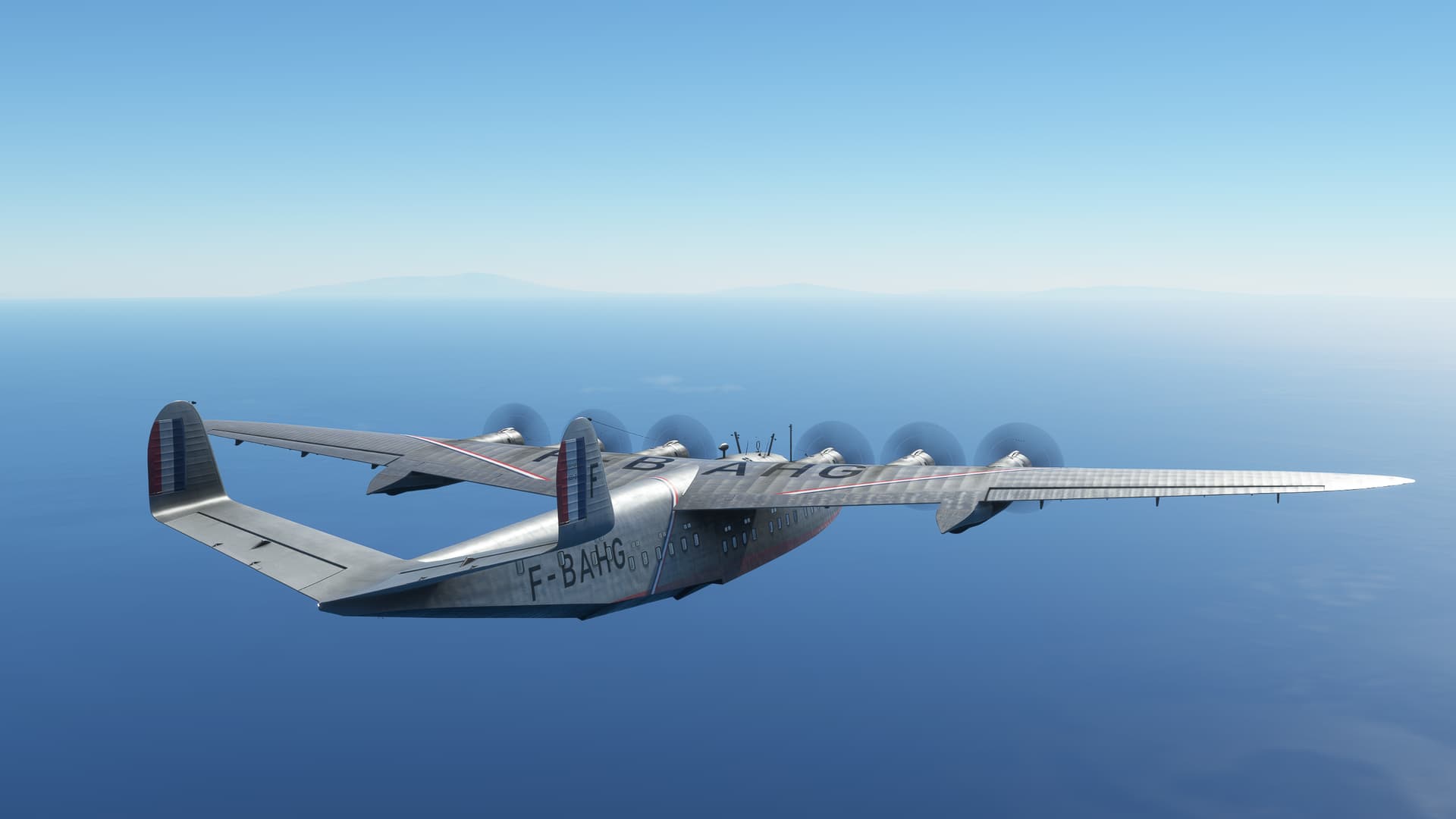
Fortunately for me, 2023 proved to be the “Year of the Flying Boat". ![]()
Enter the Latécoère 631. A beautiful, buxom, behemoth of a French Flying Boat with a capable (if basic) autopilot and a flight deck that you could play shuffleboard on. As sad as I was to leave my Clipper dreams behind, this would be a lovely ride.

San Fransisco Bay. 0700L. Just before dawn, but still darker than a black steer’s tuchus on a moonless prairie night under the marine layer. Hoping that no one in the Bay area had decided to do a little predawn angling, I pushed all six throttle levers forward.

And, with an agreeable lack of crunching sounds, lumbered into the air over San Fransisco Bay. My original intention had been to circle up, remaining over the water until I was clear of the surrounding hills, not to mention setting myself up for a better start than last time.

Which I didn’t quite manage, crossing north of the city. As consolation, at least I got a good view of the Golden Gate Bridge in passing.

The Latécoère is a very pretty aircraft. But a bit…French. French, in that I don’t speak the language. I found myself having to use a good bit of intuition (and tooltips…and Google) to figure out what to push, pull, or set. It doesn’t help that this thing has a near Concorde level of instrumentation smeared all over the flight deck. It’s enough to make a single pilot busier than a one legged man in a butt kicking contest.
That’ll be important later…


As the sun broke the horizon, I made ready for my first sextant shot.

The Navigator’s station, where I spent 80% of my time. Importantly, it contains the only clock in the aircraft. This proved to be a challenge as I had had to manually set the time in sim in order to make the daylight work out. Unfortunately, that meant, if I wasn’t at this desk, I would have no idea what time it was.

To keep me from missing a sighting (as I spent as little time sitting at the desk as possible), I kept my own time with a small pocketwatch that I had gotten at the Royal Observatory, Greenwich, England. It seemed appropriate for the task. The hard part was keeping in mind that this was going to be my time for the next eleven hours.
You never realize how many clocks you have in your house, until you try to ignore them all! ![]()

While I kept PPOS off for most of the flight, I did (at first) briefly toggle it after each sighting to evaluate the quality of the fix. Here, my celestial position is indicated by the intersection of the three lines to the northwest of the red circle. The aircraft symbol still represents my PPOS. So, not great, not terrible. This first sighting did take place after my climb out, however, so I wasn’t quite in steady state cruise yet. As the airspeeds change, winds shift, etc. my path and speed might have been expected to waver a bit.
I also didn’t figure any winds into my Dead Reckoning solutions. In general, I’m fairly circumspect about the winds aloft (particularly over water) in MSFS. On previous flights, I’ve seen weather stop or start abruptly, winds not match weather products, and other anomalies that make me a bit reluctant to bite off on any varsity corrections until I see it with my own eyes in the sim.

As it would turn out, it took me several fixes to refine my groundspeed calculations and “catch up” to where I thought I should have been. On the plus side, this Old School method seemed to be doing a better job of keeping me on course laterally.
Or so I thought…

The next several hours passed more or less like this. A flurry of activity: plotting my DR position, calculating my celestial data, crosschecking my instruments. Then 40 minutes or so (my ciphering time dropped considerably with practice) where I try to stand up, walk around, and play the long game. Finally, back to the dome to take my next sighting.
Rinse. Repeat.

It was shortly before the 2100Z sighting that it happened.
I had gotten up to stretch my legs, only to return to find the ship slowly dutch rolling back and forth and the altitude unwinding. Looking at the engine instruments, I saw that the RPM on all three starboard engines had dropped. I wasted precious time misdiagnosing what I thought at first was a simism, since what could have made 3 of my engines fail simultaneously?

Then, the left three engines began to sputter as well and I performed an unceremonious water landing onto the uncommonly pacific waters of the, um, Pacific.

What could have made the engines quit? Fuel. Lack of fuel could have made the engines quit.
This one was on me as Pilot In Command. While I had read the slim but colorful manual for the Latécoère, I still walked away not quite knowing whether I needed to manually transfer fuel from the Aux to the Mains, or whether (simism or not) the transfer happened automatically. Maybe it was that the entire process of transferring fuel in an airplane with six engines (and at least twelve Cessnafulls of engine instruments! ![]() ) was supposedly controlled by the single tap shown below.
) was supposedly controlled by the single tap shown below.
Or maybe it was that this tap was, somewhat unhelpfully, labelled “Fuel Shutoff Valve”, though one could argue that this is technically correct. Whatever it was, I had grown increasingly reluctant to turn this valve as the hours passed behind me in case I somehow misunderstood and starved, rather than fed, the engines.

I had been keeping an eye on the fuel levels in any case of course, waiting for the moment that the mains would run dry. In retrospect though, I’m not sure why. If I waited for the engines to quit (as they had), it would have taken me as long to select the proper instrument view and fix it as it would have to have actually run back there in real life (they’re on the back wall of an at least 15ft long flightdeck). So, the odds of me taking my attention away from flying the airplane long enough to go hunting stopcocks and not crashing were (had I given it any consideration) incredibly low.
The fact that the tanks chose to empty while I was in the Loo was just a hilarious coincidence!
A smart pilot might have tested this system before he went overwater (ala ETOPS). But, like unicorns, there were none of those on this flightdeck. ![]()

And so, there I sat, bobbing like a Seagull, in the middle of the Pacific Ocean. Approximately 856NM from Hawaii. 7 hours into my 11 hour trip.

I’m not going to lie. This one almost tripped my “F-it” wire. ![]()
![]()
10 Likes
Well, I feel a little bad calling him out, but his video is not at all bad, I just think he got his signs mixed up!
MSFS - Celestial Navigation Introduction and Tools (youtube.com)
MSFS - Celestial Navigation Part 1 (youtube.com)
MSFS - Celestial Navigation Part 2 (youtube.com)
He has quite a few videos uploaded and he’s very enthusiastic, but his brain seems to outpace his speech a bit. Not like I’d know what that was like! ![]()
The real unfortunate part of this is that he stated that he had intended to post several more videos about Cel Nav, but never seemed to get around to it. He only posts 3 I think.
Why that was particularly bad for me was that he only posts two examples, one of them wrong. If he had continued, I think it would have become obvious that there was an outlier in his work.
Honestly, once you get the hang of it, Cel Nav isn’t difficult, so much as it is prone to mistake. In the web based method, a lot of the table look up is reduced which vastly decreases the likelihood of messing up the sign or being on the wrong page.
That second one is no foolin’ either! If you look up these tables online, I found it almost impossible to read the values and keep the column headings in view at the same time. I’m pretty certain that these things are still published as if they were books, where you could lay your navigator’s plotter across them and find the value.
There were at least two times, that I know of, where I found myself on the wrong PDF page. And a few more that I learned to ignore as they were so far outside what I would consider a reasonable solution!
There is a tutorial that comes with the Cel Nav app, and he posts videos on YT as well, that I used from the Hawaii leg on.
More work, but more satisfying as well!
This, I believe, is the author of the Cel Nav app.

4 Likes
What a story!

Is the Clipper still not working properly? I recall somewhat heated discussion in one other forum but then lost interest and track of its state. A good looker for sure… and with great plans from the devs… and then perhaps ran over by… how did you put it?
Oh yeah:
Thanks for the videos. The way the shots are plotted in LNM is Chinese to me. Need to watch the videos carefully ![]()
I suppose that once the fuel transferred to the mains, you could just store the fishing rods and fly off?
3 Likes
I don’t know how the Clipper is working generally, but every time I would engage the autopilot, it would wander back and forth then settle down on some heading…but not usually the one I engaged it on.
That’s what I would call…


A CLIFFHANGER!!! ![]()
4 Likes
Absolutely stunning views, congrats!
2 Likes
Awesome! Despite the…troubles…you would have made even Jack Aubrey proud. ![]()
2 Likes
You have taken complexity to a new level sir. Without a team to help, I can’t see how you stay sane, but you have constructed a thrilling journey for us. I laughed, I cried, I screamed in terror. Can’t wait for the next installment!
4 Likes
Oh, that ship sailed long ago!
2 Likes
This is so awesome! I am elated to experience this through your writing, having never taken the time to try the Latécoère or celestial navigation. I already get stressed just thinking about having to go back to the pc every now and then over an 11-hour period.
But I LOVE the weird French flying boat, and the idea of crossing a vast ocean in such an old manual plane, using centuries old techniques to navigate.
The way you write it all is just the cherry on top! I can’t wait for the next episode!
4 Likes
Hehe, thank you very much.
I certainly exemplify the following sentiment!

5 Likes
I always tell people who are perfectionist or scared to make mistakes:
Making mistakes is necessary to improve and to learn. When you do the whole thing in public, it’s called teaching.
3 Likes
The good thing about making a mistake is that it allows you to recognise it when you do it again ![]()
This is epic, I’m loving it.
1 Like
that was great ![]()
Cel Nav sounds great, I wish I never have the time to learn it ![]()
back to dead reckoning at FL500+ and shooting an intercept to Iceland


high alts, supercruise, I find it quite relaxing

up until that moment when you have to find the land to hit


Reykjavik


11 Likes
Okay, onward! PAYA to PASD:

Early start, again. It seemed like clear sailing and then…Community Folder conflicts :(. After three sim crashes, I tore everything mod out and spent the day finding the conflict with latest MSFS Update. So that was last weekend.
This weekend, trying again with my now un-Modded TBM 930:

This time, a little soupy. But no more sim failures. Eventually, I did get over it:

And, flew around it:

At long last I reached PASD and lo, clear skies:

Alas, all this clarity was courtesy of a 34kt wind. While I managed to get it down I must admit that it was a grass landing (and not a grass strip). But back on the ground is back on the ground.

So I will take it!
12 Likes
Any landing you can walk away from… ![]()
5 Likes
On our way eastward I fly the C-17 from Ashgabat, Turkmenistan to Dushanbe, Tajikistan. Places I have a hard time to find on the map, and never ever been too even close in reality…
Quite a soup at Ashgabat upon take-off, and not exactly aligned with the runway after take-off.

A few kilometer later the sight gets better, luckily for me.

The rather barren brown gives way to a valley with fields eventually, but this is soon left behind.

In the distance the Pamir mountains can be seen.


This time the descent went well, 34 nm out and at 10k feet I feel that I won’t do an extra leg around the airport.

As we approach Dushanbe, the C-17 in its landing configuration.

Some confusion on the way to the airport. I mistook this airfield besides it being not exactly on the route for the airport and steered towards it. With that error recognized, I wonder where the airport actually is? Can it be right behind Dushanbe downtown?
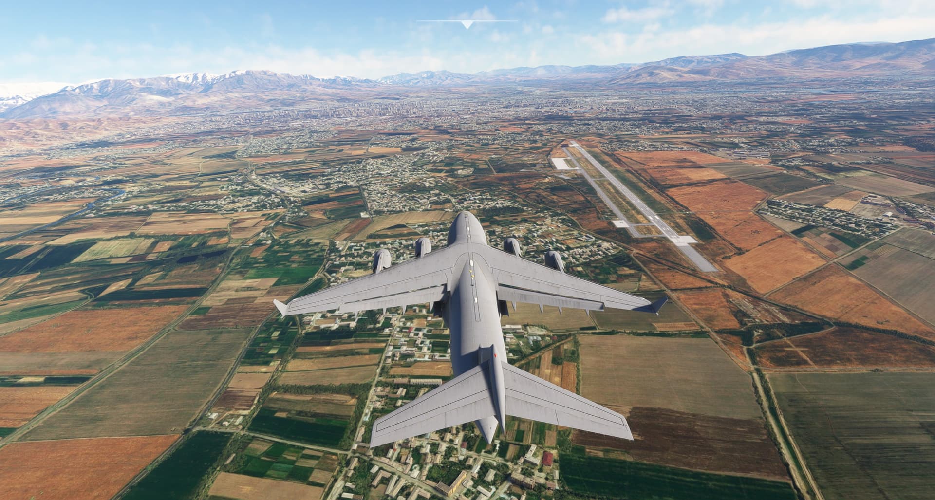
We fly a tad bit low over the urbanized area…

And managed a decent landing at Dushanbe airport.

While probably not my assigned parking position, it’s one at all. We’re just a bit oversized in comparison ![]()

This is the last stop before entering China. Time to get rid of those Apache helos in the back…
9 Likes
CHAPTER 4
WATER, WATER EVERYWHERE…

Approximately N28 30, W144 22 TO Honolulu International Airport (PHNL), Honolulu, HI
10 October 2023 2100Z (local time unknown)
856NM. ETE: 3+50.
So, there I was, 856NM from Hawaii. Once I transferred fuel, I had nearly full mains and plenty of daylight left. Well, at this point I was going to be damned if I didn’t at least finish this leg.

Besides, we were running out of champagne.

Once more unto the breach, then.

I picked up where I left off, which turned out to be something of a cheat. I had, after all, placed the aircraft where I thought I was, not necessarily where I actually was. But, at that point, I didn’t especially feel like splitting hairs.
After an hour, I took my first (next) sighting. Interestingly, even with a comparatively short segment (and light reported winds), there still seemed to be a limit as to how close I could get sighting the Sun.

I had begun to wonder if there wasn’t a certain amount of trigonometry working against me here. All my sighting was really telling me, as I understood it, was that I was somewhere on a segment of a circle (the base of a cone really) with an angular height equal to the angle of my sextant reading, as shown below. Now, where I was on this circle gets narrowed down appreciably by the Azimuth (i.e. the direction from the Assumed Position to the celestial object), but it still winds up being a fairly long segment of arc. The fact that it gets drawn on the map as a straight line is just a simplification.
(From the materials provided by the Cel Nav App)

Additionally, since you, generally, have only one celestial reference during the day, you use your Dead Reckoning position as sort of a second, pseudo-reference, then essentially blend the two. This can drag your “solution” long, short, left, or right, depending on the angle between the Sun and your course (and how good you are at Dead Reckoning!). This relationship will change also, as the Sun swings past. So, the “fix” can sometimes feel more like art than science. To add insult to injury, the calculation process itself involves a certain amount of interpolation, which I won’t bore you with, but which can subtly slew your position around.
Be all that as it may, I would still have felt better if the positions had matched up more closely.
To add hilarity to the proceedings, the Cel Nav app also had the unnerving tendency of locking up on me every once in a while. Since at this point, I still only knew how to take sightings on the hour (still debatable ![]() ), that meant that a missed sighting left me with no plot for two hours!
), that meant that a missed sighting left me with no plot for two hours!
Or, twice as much time to get myself into trouble! ![]()
Still, considering that this thing can backwards calculate celestial angles, from outside MSFS, while it’s running, I had a hard time judging it too harshly.

As I approached my last fix, I made one last check of the instruments (and got my steps in).
Fuel and oil…checked.

Engine instruments…still in French.
C’est magnifique!

At this point in my celestial education, I also didn’t feel that I was ready to try the, somewhat complicated, Landfall procedure (we’ll revisit it later, believe that!). Instead, looking at the map, I chose a comparatively small 10 degree cut to the left, juuust to dip my toes in the water and play with offsetting my target a bit.
It looked, providing that I was anywhere near where I’d thought I was, that at least I couldn’t miss Hawaii entirely.
Though I have been known to overachieve!

That done, I climbed back into the captain’s chair and began visual scanning. In the Blessed Mother of Navigation’s own good time, I was rewarded with a land sighting.
As I approached the island chain, it became apparent that I would be coming “ashore” over Molokai. With more than enough gas, but without Oahu in sight yet, I chose to continue straight ahead then pick up a heading to the northwest, if necessary, to hunt for Honolulu.
Some radio instruments would have done me a treat right about this point. But as far as I could tell, the MSFS Latécoère had none…at least not in the sim.
Still, the weather was good, the Sun was high in the sky, and I was feeling fairly confident about where I was…for a change.

As it turned out, Oahu would become plainly visible well before I crossed the main axis of the islands. I started my big right hand turn towards Honolulu as the backside of the island came into view.

I also chose to keep high (well, 2750m/9000ft) until I got a little closer, which gave me a nice view of Diamond Head.


Then, a quick right hook around brought me alongside Waikiki Beach.
I figured that the least I could do for their inconvenience was deliver the passengers directly to the hotel. I don’t imagine these tickets were cheap back in the day!


After landing, I pulled in close to the beach. A quick tug assist to the dock and I would call this one complete.


Well, that was interesting.
Bringing up the track in Little Nav Map, it again only recorded some of my progress. The more I looked at what did show, however, the more difficult it became to know quite how successful I had been. Obviously, the goal was to follow the yellow course line. But my “best” fixes (where the distance between my fix and reality was least) were not necessarily the ones that were closest to my course. As far as the former went, it looked like I held a deviation somewhere between 60 and 70 miles. Not exactly knocking it out of the park, but I’m not certain what I could have done differently.
As far as lateral distance from course goes, I probably got as far as 80 miles south. I was heartened to a degree by the fact that at least I was narrowing the deviation when I turned the plane into a glider (and then a canoe). I’d like to think that, had I gotten to continue all the way from San Fran, I would have at least gotten myself close enough to Hawaii to spot it. But truly, I’ll never know.

The second portion of the flight went considerably better, in both respects. That made me wonder a little.
I found keeping track of time a bit weird in MSFS. Not only might you be flying at some other time/date than it actually was (unless you’re willing to keep some unusual flying hours). But also, because of the way that MSFS lets you select LOCAL time, but automatically chooses ZULU date, it’s possible that your not even flying on the day that you think you are, unless you’re very careful.
That would put all my calculations exactly one day off. And the second (better) portion of the flight had been from a fresh start and a fresh time selection. Hmmm… ![]()

In any case, I had made it, by hook or by crook (or is it Cook?) to Hawaii, using nothing but the Sun. While it may not have been pretty, I thought the occasion called for a little celebration.
Vive La France!

14 Likes