Official 9th Annual Mudspike Christmas Flight 2023 - Discussion and AAR Thread

congrats @weaponz248 and @boomerang10 !

had the same moment yesterday. but from that moment she completely occupies my thoughts :slight_smile: I guess I will have fun with her, single engine, two seats, british accent

so yeah @Stormy801 , unfortunatelly my Tweet is unrecoverable from that bay :slight_smile:

7 Likes

Great job @weaponz248 and @boomerang10 and great reports!

3 Likes

Congratulations! Well done!

I was just thinking the same thing! I think that’s gonna be my route.

(in my best “Stormy the wise” voice)
Rumors tell of men who are unphased by such challenges. They seemingly swim like fish and stay underwater hooking their tentacles onto machines and animals alike, ignoring the cold and darkness. They control mighty dragons that can lift anything their hearts desire, or for the right coin, whatever their masters desire. I do not know how one would summon these men, they seem to just appear at the right time, but maybe you should have such luck that you…dare I speak it… you might retrieve your beloved tweet from the cruel fate that it suffers. Few have seen them, but perhaps you can pray to their likeness and summon them.

6 Likes

we know at least about one such man, @smokinhole ! he has the right stuff for this job, the right stuff and XTrident Chinook :slight_smile:

3 Likes

Today, I flew the beam.

What Is It Reaction GIF by Nebraska Humane Society

Radio Range Navigation, or “the range”, was the main navigation system used by aircraft for instrument flying in the 1930s and 1940s, until the advent of the VHF omnidirectional range (VOR), beginning in the late 1940s. It was used for en route navigation as well as instrument approaches and holds. (Wikipedia)

It consists of flying towards the station which is emmiting morse A and N signals depending on how far one is away from one of the four fixed beams. If on the beam, the A and N morse signals blend together into a uniform tone.

A-N-signals

Sounds familiar? Then you have just probably recalled @Deacon211 AAR from the last year’s Christmas Flight. We miss your golden AARs @Deacon211!

Yongphulla in Bhutan to Tezpur in India.

As I thought I might be rather busy navigating this old system, I reached to my hangar for the Electra which, at least in this MSFS rendition, is rather a simple-to-fly bird.

Aeroplane Heaven did a nice job in terms of modelling but let the Electra down in terms of sounds & system & engines accuracy. Some of that stuff I fixed myself and even was able to bolt the Big Radial’s Goose wwise sounds to the Electra as these two share the same type of engines. It works just OK. I miss some cockpit sounds, which is OK, and engine start up sounds, which is a pitty, but the rumble of the engines once started is worth it! :+1:

Getting ready and taking off. The Electra was on its MTOW so at this altitude (some 8500ft) was quite sluggish to lift off.

The plan was to intercept the 137 degrees beam to the station from the A sector and then follow it down to Tezpur. If flown correctly, I should overfly Misamari airport once clear of the mountains.

The ability to fly the beam (Radio Range Navigation) in MSFS is brought to us thanks to a mod by ElectronVolt. https://flightsim.to/file/21201/radio-range-navigation

FtB tuning

Heading 100 degrees from my departure airport, I could hear a clear A signal as expected. After some time I noticed a weak N signal which became stronger when closer to the 137 degrees beam. Here the two signals became indistinguishable and blended into a uniform tone. Time to turn 137 degrees and start flying the beam (note the advanced vibration monitoring equipment on the glareshield; nice touch Aeroplane Heaven :+1:).

Time to start descending as well. The approach chart above called for overflying the station at 3000 ft then descend to 2000 ft outbound from the airport, turn back and land. No big math this time. I just estimated the descend rate between 1000 and 2000 fpm should do.

Misamari airport. Bang on the beam!

The signal gets louder as you approach the station. In this screen, you can make the masts.

I have to say listening to blending A and N morse signals over a prolonged period of time becomes quite nauseating. But since I was flying in VR with no desire to leave VR, lift the HMD and switch off the RRN radio, I decided to press on and ignore the signal instead. I was already visual with Tezpur. When I called the tower to get an active runway, I was advised that the airport was IMC. Well, honestly…

Do you recall I claimed that this leg would take me some 80 years into the past? This is why:

The next leg will be part of the Hump route flown by the USAAF during the WWII over Himalayas to resupply the Chinese war effort of Chiang Kai-shek. So naturally I installed appropriate scenery :slight_smile:

The Electra is maybe a little out of place here in 1944 Tezpur airport scenery but it still makes for nice screenshots :slight_smile:

Next stop is Chabua. I have not yet made my mind whether to fly the beam again or go with the period NDBs… let alone whether to take a DC-3 (or shall we pretend a C-47?) or a B-307 (and pretend it is a C-46). We shall see.

Stay tuned.

13 Likes

nice to see you @Deacon211 !
no speed run from you this year? Concorde / Blackbird / Darkstar are still valid options :slight_smile:

2 Likes

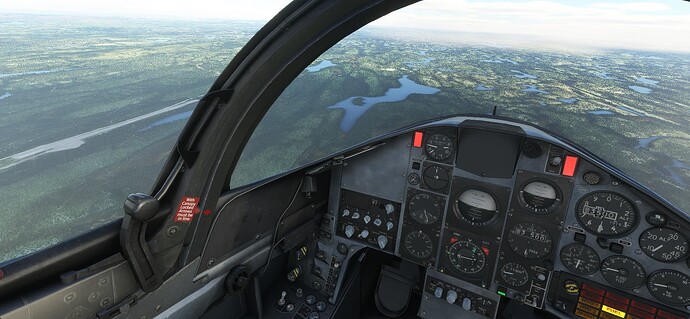
planned for some short first hop in the Hawk, ended up flying for some 175nm

she is quite agile, made 1.05M in shallow dive

my planned destination was CYAH La Grande IV. but again MSFS decided to exclude this airport. should have checked beforehand :slight_smile:

made it all the way to the next one, CPM3 Pourvoirie Mirage Airport. tweaked the weather little so I can enjoy the scenery before touchdown

yes I know I know, but we are almost there (I mean my copilot is driving by car, didnt want to endanger him on this first flight :slight_smile: )

nice place

down the road from airport

10 Likes

Nevo are you from this part of the World?
I googled the airports, the amount of fresh water in that area is incredible. The fishing must be Fantastic.

definitely never been to Canada.
I believe so. fishing, hunting and flying helicopters. what could one wish more!? :slight_smile:

1 Like

Hehe, thanks guys. It’s been a heck of a few months. I’ve eagerly been reading all your reports, but wasn’t sure that I would be able to participate or finish this year.

So, I’ve saved it all until the end. I post it soon, though you may regret asking! :rofl:

6 Likes

After last year’s epic journey and AAR’s… Never!

Reminds me, I have a finger to pull out :thinking:

5 Likes

Well, I stopped for the Chicago Beef Sandwich and a tour of the resurrected Meigs Field and never got back in the air. Life does get in the way sometimes. So, I have ditched my trusty Bonanza V35B for a TBM 930 (the guy on the corner of Randolph and Lakeshore gave me a good deal as long as I didn’t ask too many questions ;). It’s the fastest plane I can manage.

Off to Minneapolis:

After a little shakeout, trying to find all the buttons and get used to how she likes to fly, spent a nice few hours above the clouds.

From KMSP, decided to make the big jump to Edmonton. The is just about the limit of both fuel and available daylight. Made it just as the sun was going down:

Oh Canada! Our home and native land!..that’s all I remember. Next, need to figure out the hop to Anchorage. But first, where can I find some good some Poutine.

13 Likes

I live in hope that someday I will find the proper cheese curds over here so I can make it… Heck, I can’t even get real grits. The best I can hope for is coarse ground polenta, but it just aint the same :frowning:

1 Like

Harry - It’s sooooo good! In Poutine and fried in Cheese Curds. How can we get you to Wisconsin?

2 Likes

I was about to say a 1st Class ticket would do it, but this is Mudspike so Business Class will be OK… I’m not fussy about the airline :stuck_out_tongue:

2 Likes

Leg 3.

Darwin to Singapore. Long flight but a short(ish) post because there isn’t much to see - mainly over water but also because we are leaving Australia and HD mesh & Ortho scenary behind…

Bye Darwin, you are exactly how I remember you, hot, humid and a horrible place to live:

Next landfall was Timor, I may have spent a bit of time down there? I make no excuses for using time acceleration for most of this leg:

Skirting the Southern edge of Borneo I thought I would try to make it a bit more interesting (for me) and do a bit of ‘lower’ level hand flying. Unfortunately the textures down here just aint that great:

I decided not to use the GTN plugin for this leg so deliberately aimed for the Northern coast of Sumatra to begin my run into Changi:

And picking up the localiser for 02C:

Singapore, lovely place to visit not sure I would want to live there?

Way too high, fast and to the left… let’s call this a missed approach shall we?

Third (maybe fourth or fifth :slight_smile: ) times the charm:

Parked and now to decide where next… I am rapidly running out of time.

12 Likes

Yeah, It might be tricky getting your dance card right. Great food though!

Happens to the best of us.

2 Likes

Oh yeah, the food is probably some of the best I have eaten anywhere in the world…

A mate of mine has been living and working in Singapore for over a decade now. I have visited a few times and between that and work, Changi is a close 2nd behind LAX for a most visited foreign major airport.

But the oppressive heat, humidity and authorities preclude it as a place I would move to.

2 Likes

Are you sure you’ve never lived in California? Because that sounds A LOT like California.

2 Likes

I am getting there!

Tezpur to Chabua, both in India.

As announced at the end of my last AAR, this is one of the legs of the Hump route flown by the USAAF in the WWII.

The Hump pilots were able to haul amazing amount of cargo over Himalayas in all weather, any time of day and in unarmed aircraft. They were facing higher losses than their brothers in arms flying bombers over Europe (mainly due to weather; the Hump was nicknamed “Aluminium Trail”), yet the number of hours flown was not fully credited towards their “post-war” flight time records since they were not flying combat missions.

Finally I decided to fly the beam again, though this time in a Boeing 307 Stratoliner. Two reasons:

  • visually, it is the closest thing to a C-46
  • I wanted to work a bit on my love-hate relationship with the B-307.

And to make it a bit special, I decided to fly from the right seat :open_mouth:

Taxing towards the active runway in Tezpur. The tower was again convinced the airport was IMC so I just picked the closest one.

I kind of like the Stratoliner. It has a great potential which unfortunately is left undeveloped by Aeroplane Heaven and MS. I am aware that at price tag of some 10 euros I should not be asking much but there is still a long list of yet unaddressed issues. Question is whether they ever will be addressed. Some are minor, some are not. The B-307 does not fly like it should in terms of published performance, though for the flight today I will take it easy and ask just 10k ft from this 4-engine bird.

Btw. one of the glaring issues is the altimeter. Check it out - it has two 6s (one instead of an 8). This is a result of the last update. Seriously? :slight_smile: How can a correct texture get “fixed” in this way? In case it is an easter egg, then it is a bad one. Anyway… let’s get flying.

The external model is very nice especially in this morning sun. And since finally we have got some weather, I took maybe more screenshots than what was really necessary :slight_smile:

Yeah, the right seat feels a bit weird :laughing:

The plan was to fly the beam from Tezpur station towards Jorhat airport and then towards Chabua. Mind, that you can fly only one of the four fixed beams from the station. And one of them was an outbound beam towards Jorhat.

Problem is that with distance, the signal gets quieter to the point that it is not heard any longer over the engine noise. For that reason, I tuned the Jorhat NDB to guide me to the airport.

But it did not work.

And it was right in not working since I was dialing the NDB frequency on the Transponder.

Ugh Frustrated GIF by Equipe de France de Football

Eventually, I got over Jorhat and started to follow the Brahmaputra river north-east towards Chabua.

Having figured out the radio navigation in the Stratoliner, soon I picked the Chabua NDB signal as well as the Radio Range Nav signal.

Here I am nicely on the beam and slowly descending.

Briefing for arrival to Chabua. I wanted to fly the full procedure.

Overflying the field.

Here I am already on finals.

No, I did not fly the 3 minutes outbound segment from the station before reversing the course :slight_smile:

Down and flexing all the bells & whistles.

It has been a long way up to here and the next leg will actually take me finally to China. Not the final destination yet, though.

Stay tuned.

13 Likes